
26 February 2010
Piedmont rocks exposed in a creek
Posted by Callan Bentley
One of the cool things about being the local geoblogger is that people get in touch with you about local geology. Sometimes this even leads to meeting up for field trips. Here’s two quick photos from a recent (January 2010) field trip to a creek near Springfield, Virginia.
My host was Barbara X, a local aficionada of Piedmont geology. She has lived in this particular neighborhood for many years, and is very familiar with the local woods and drainages through decades of dog-walking there.
Her main question for me was “Could the geologic map of this area be wrong?” She showed me the map, and then took me out to an outcrop which clearly was of a different rock type than the map indicated it “should” be.
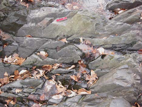
The offending intruder, a meta-basalt with two prominent joint-sets:
A short distance downstream, a cut bank revealed some saprolitic rock that is more typical of the Piedmont province:
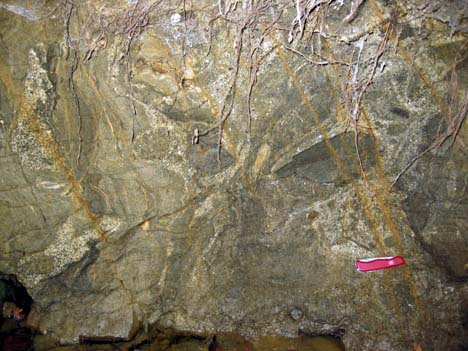
I think we’re seeing bodies of schist/ gneiss (highly foliated in cross-section), as well as coarse-grained, lighter-colored bodies of granite. All of them have been weathered to hell: you can scoop handfuls of this “rock” out of the outcrop if you want. If you’re a plant, you can plunge your apical meristem right into it, and let the roots follow.
This is typical “outcrop” around here: though the mid-Atlantic region has a fascinating story (including the Appalachian mountain belt, like these rocks), the wet climate has rotted most rock away. The only other thing that’s worth mentioning about this particular outcrop are the upper-left-to-lower-right brown lines: those are fracture traces decorated with rust. The fractures serve as plumbing to move fluids around in the subsurface, and their dissolved cargo of elements can then react with the rock on either side of the fracture.
 Callan Bentley is Associate Professor of Geology at Piedmont Virginia Community College in Charlottesville, Virginia. He is a Fellow of the Geological Society of America. For his work on this blog, the National Association of Geoscience Teachers recognized him with the James Shea Award. He has also won the Outstanding Faculty Award from the State Council on Higher Education in Virginia, and the Biggs Award for Excellence in Geoscience Teaching from the Geoscience Education Division of the Geological Society of America. In previous years, Callan served as a contributing editor at EARTH magazine, President of the Geological Society of Washington and President the Geo2YC division of NAGT.