
4 July 2011
Report on IVM-Fund trip to Guatemala: Part 3
Posted by Jessica Ball
From April 29 – May 3, 2011, Dr. Jeff Witter of the International Volcano Monitoring Fund (IVM-Fund) made a trip to the Santiaguito Volcano Observatory (OVSAN) to deliver a set of volcano monitoring equipment. This equipment was purchased with the proceeds from a fundraising effort that I and the OVSAN personnel conceived of and that Jeff helped put into action. Jeff did a great writeup of his experiences in Guatemala, and asked that I share it with everyone who has contributed to the fundraiser (and anyone else who is wondering what that “Donate to Guatemala” button is on the top of this blog). If you’ve donated to the fundraiser, thank you, and please enjoy the results of your generosity! If you’re thinking of donating or are interested in learning more about the effort, please click on the “Donate to Guatemala” tab and visit the IVM-Fund website.
Trip report by Dr. Jeff Witter:
Day Two: May 2, 2011

View at dawn from OVSAN to Santa Maria volcano (the taller one) and Santiaguito volcano (the shorter one). The distance to Santiaguito is ~6 km.
I [Jeff Witter] woke up around 6 am and, still half asleep, I stumbled outside to see a beautiful clear sky and unobstructed view of both Santa Maria and Santiaguito volcanoes. The OVSAN personnel were already awake using their new binoculars to make observations of the volcano. At this time of year, just prior to the onset of the rainy season, days are usually clear from sunrise to ~10 am when the clouds come in and visual observations of the volcano are no longer possible. The observers made sure to take full advantage of these important morning hours. We had breakfast of sweet bread and coffee and watched an explosion at ~6:15 am. Using the new clinometer, we measured the angle to the top of the ash plume and then did a little trigonometry to determine that the plume reached a maximum height of about 4400 m above sea level or about 1900 m above the Santiaguito crater.
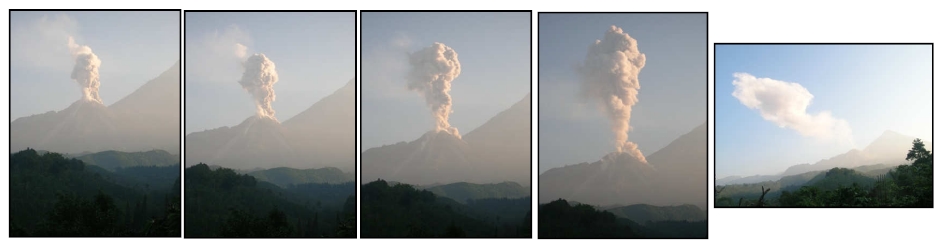
Series of photos showing progress of a single volcanic explosion at Santiaguito. This explosion commenced at ~6:15 am on May 1, 2011. Maximum height of the explosion (fourth photo from the left) is about 1.9 km above the lava dome.
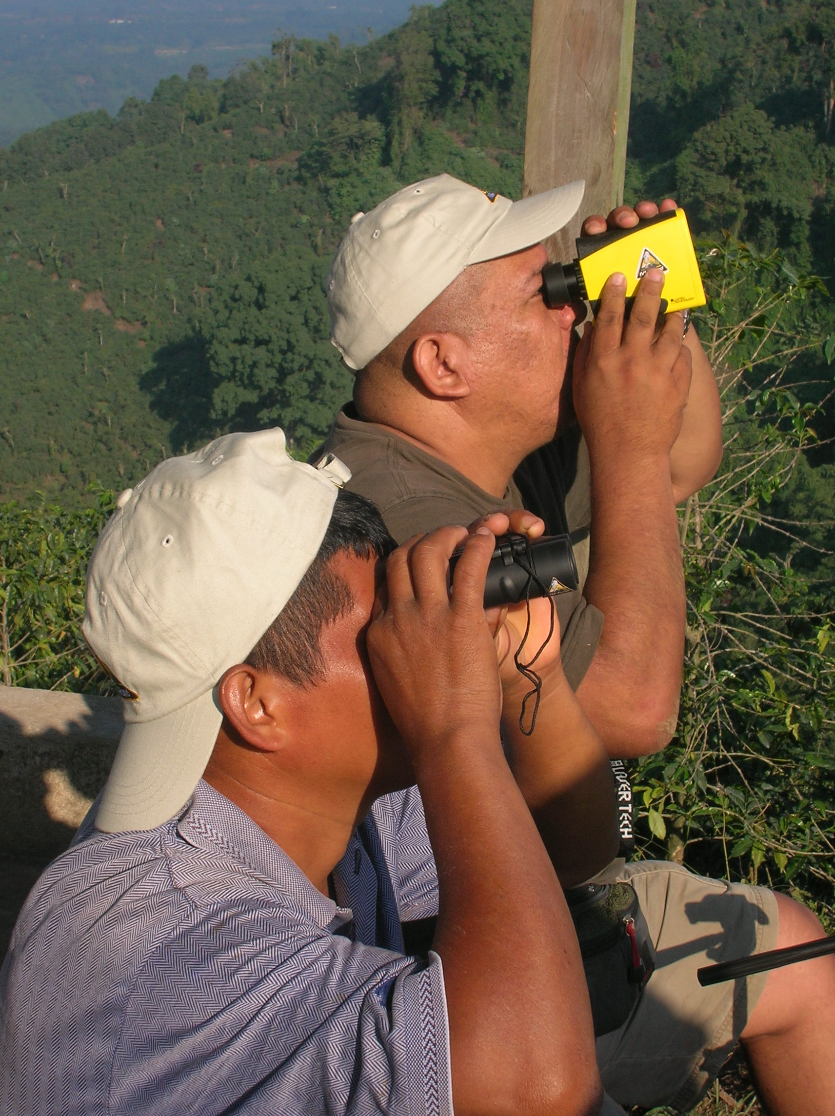
Manuel & Julio observing Santiaguito using the new binoculars and laser rangefinder.
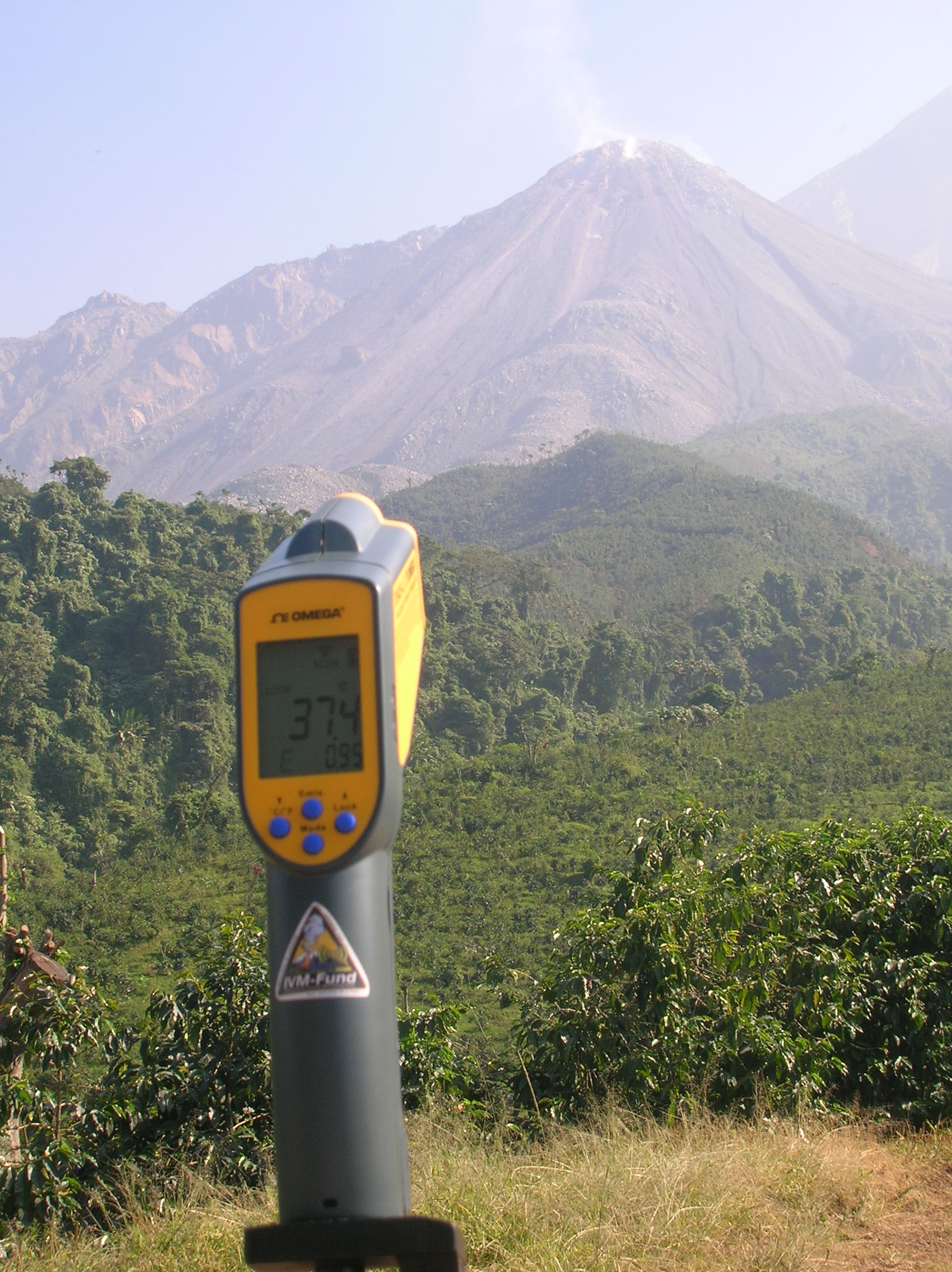
Testing the infrared thermometer.
By 7 am, we decided to head out and drive one of the stone roads to the upper reaches of the El Faro coffee plantation to enable closer observations and make measurements of Santiaguito with some of the new equipment. As we hopped into our field vehicle, I noticed that the leaves on coffee plants as well as the windshield of the pickup truck had been dusted with a thin, discontinuous layer of volcanic ash that presumably fell the night before. By ~7:30 am, we arrived at the ‘Lookout’, a small roofed structure, with a perfect view of the Santiaguito lava dome. We watched another explosion and could hear the continuous volcanic rumbling and clatter of rocks tumbling down the flank of the dome. Gustavo told me that in recentweeks, Santiaguito had been averaging one explosion every hour to hour-and-a-half. At the Lookout, we were only ~2 km from the active crater of Santiaguito. The stone road continued beyond the Lookout, heading even closer to Santiaguito, but Gustavo advised that we go no closer because the next observation station is in an area at risk of pyroclastic flow inundation caused by new activity on this side of the lava dome. At the Lookout, the observers broke out all the equipment, tested them all and made observations with the infrared thermometer, laser rangefinder, clinometer, digital camera, and both sets of binoculars. Important quantitative measurements such as eruption column height and lava dome temperature can now be made at Santiaguito thanks to the new equipment.

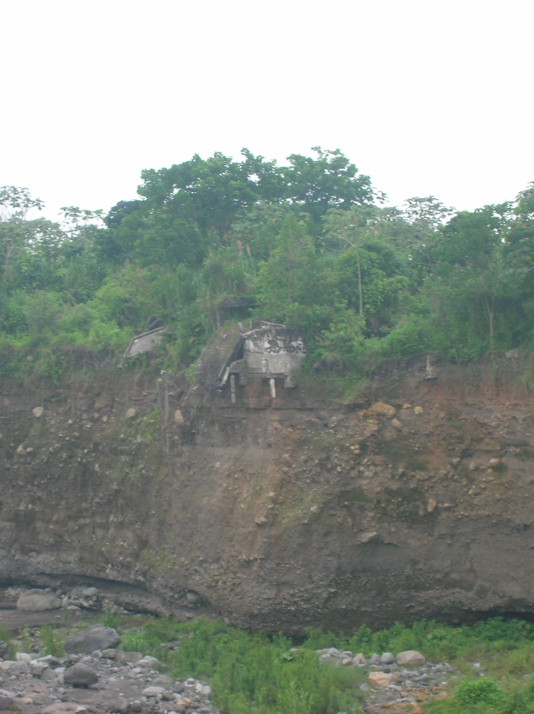
OVSAN personnel measuring the depth of a lahar channel only a few kilometers from Santiaguito.
Gustavo and I drove ~1/2 km further up the stone road to one of the seismic monitoring stations, noticed more ash covered coffee plants, and observed yet another volcanic explosion before heading back towards OVSAN. On the way back down from the Lookout, we stopped at a short bridge crossing a deep canyon. Gustavo told me that prior to 1997, a bridge wasn’t even needed here since the stream that crossed the road sat in a shallow dip that you could easily drive across. Over the years, lahars (volcanic mudflows) descending down the streambed from Santiaguito have cut a deep, vertical-walled canyon. Alvaro and Julio both measured the depth of the canyon using the new laser rangefinder and got 26.8 m. Last year, the canyon was ~33 m deep which shows it has refilled a bit with lahar-borne sediment. The OVSAN personnel plan on making repeat measurements of the depths of lahar canyons, using the new laser rangefinder, at various locationscan track the deposition/removal of sediment and thereby gauge the volume of sediment available to generate lahars that could potentially inundate populated areas downstream. The time of my visit coincided with the beginning of the rainy season. With the recently increased explosive activity at Santiaguito and production of more loose volcanic material, Gustavo fears that the coming rainy season will spawn more lahars which could fill river valleys, cause flooding, destroy bridges, and cause other damage. Thanks to the help of the IVM-Fund, OVSAN personnel now have a new tool to help them make more quantitative measurements and track lahar hazards.
Former central market of El Palmar now perched on the edge of a cliff above the new channel of the Rio Nima I.
The potential impact of lahars from Santiaguito was made very clear to me that afternoon when my Guatemalan hosts took me to El Palmar, a town destroyed by lahars and subsequently abandoned. Prior to 1982, El Palmar was a thriving agricultural community of ~7000 inhabitants, complete with a central market, town square, and cathedral. The town sat astride two small rivers thatdescended from Santiaguito named Rio Nima Nima II. In 1982, the western half of El Palmar was destroyed when a lahar filled the channel of Rio Nima II in one hour. The lahar then overtopped the banks of the river channel and buried an entire neighbourhood of homes beneath a couple metres of mud. The half of the town near Rio Nima II was abandoned but people still lived along Rio Nima I until 1998 when the rest of El Palmar was destroyed by lahars ‒ but in a dramatically different manner. Prior to 1998, the Rio Nima I was a small river flowing in a ~1 m deep channel. Then erosive lahars descended the Rio Nima I and carved a new channel, 15 m deep and 50 m across, right through the center of town. Subsequent to this event, El Palmar wascompletely abandoned. Today, the remains of both the town cathedral and market sit on a cliff edge, on the verge of collapsing into the river valley below. The Guatemalan government has declared the area off-limits to human habitation, yet despite this designation, several families from other parts of Guatemala (who apparently don’t appreciate the lahar hazards of Santiaguito) have moved into the area and re-occupied the site of the abandoned town.
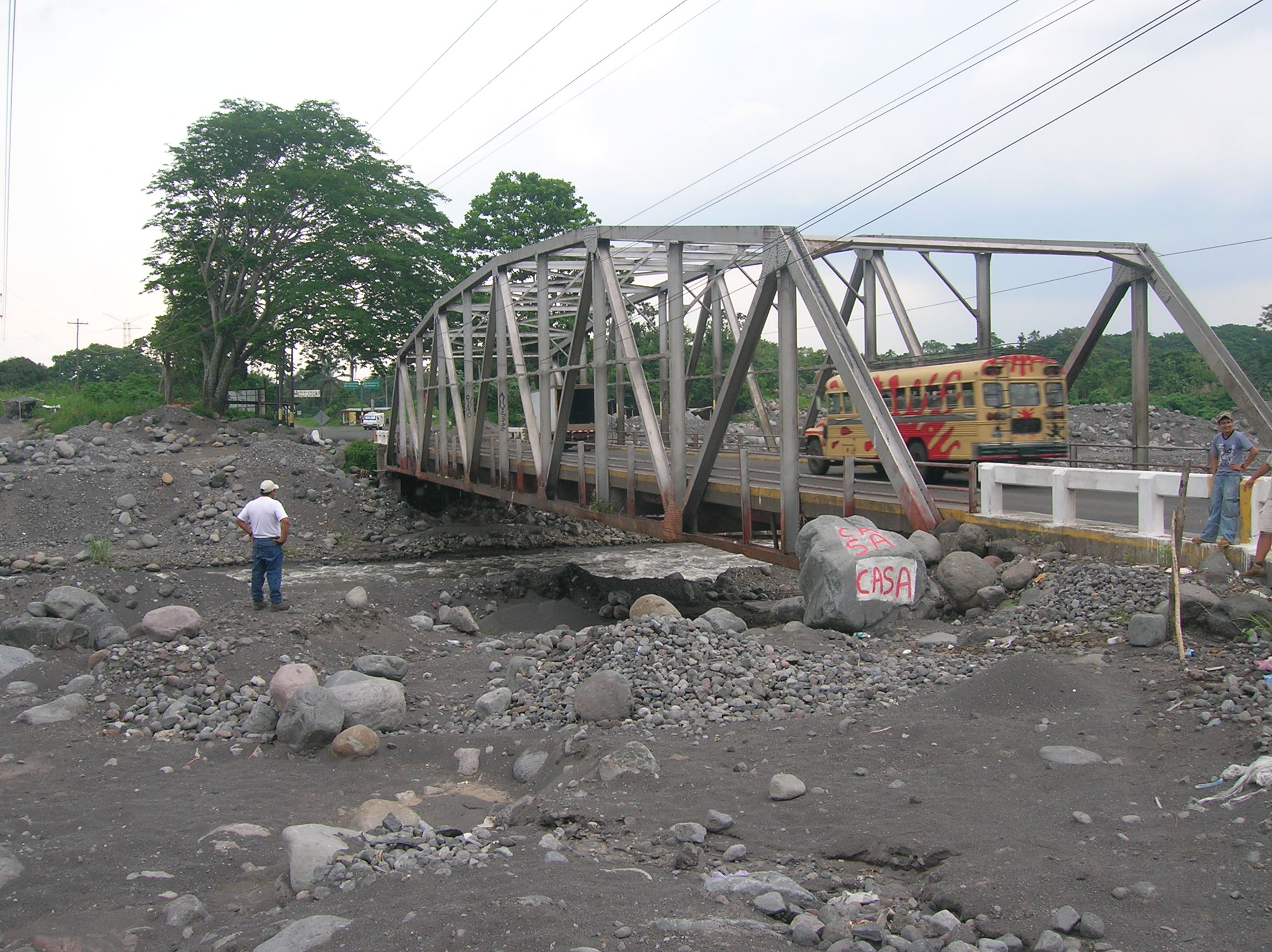
Highway CA-2 bridge where it crosses the Rio Samalá, downstream from the junction of the three primary lahar pathways from Santiaguito volcano. This bridge provides a vital economic link for the region.
If a destroyed town wasn’t enough to illustrate the destructive potential of Santiaguito, my Guatemalan hosts took me by another example of a potential, lahar-caused economic calamity. We drove downstream to a large bridge that crosses the Rio Samalá. The bridge is located downstream from the junction of three primary lahar channels that drain Santiaguito volcano. The bridge is also where the CA-2 Highway crosses the Rio Samalá. Apart from the Pan-American Highway that transits through the Guatemalan Highlands, the CA-2 is teh main road and economic artery between Mexico and Central America. When constructed in 1951, the Rio Samalá river valley was 17 m deep under the bridge. On the day I visited, there were only ~4 m between the bottom of the bridge and teh river bed. Throughout the year, the river bottom rises and falls as lahars deposit huge volumes of sediment during the rainy season and subsequently take it away during natural streamflow the rest of the year. In recent years, there have been times when there was only ~1 m of daylight under the bridge, and occasionally lahars have overtopped the bridge, smashing huge boulders into the bridge’s iron girders. So far, the bridge has survived; however, the trend appears to be towards increasing sedimentation that the backhoes cannot keep up with. Gustavo fears that this year’s rainy season could generate enough lahars to destroy the bridge, which would seriously disrupt commerce between Mexico and the rest of Central America.
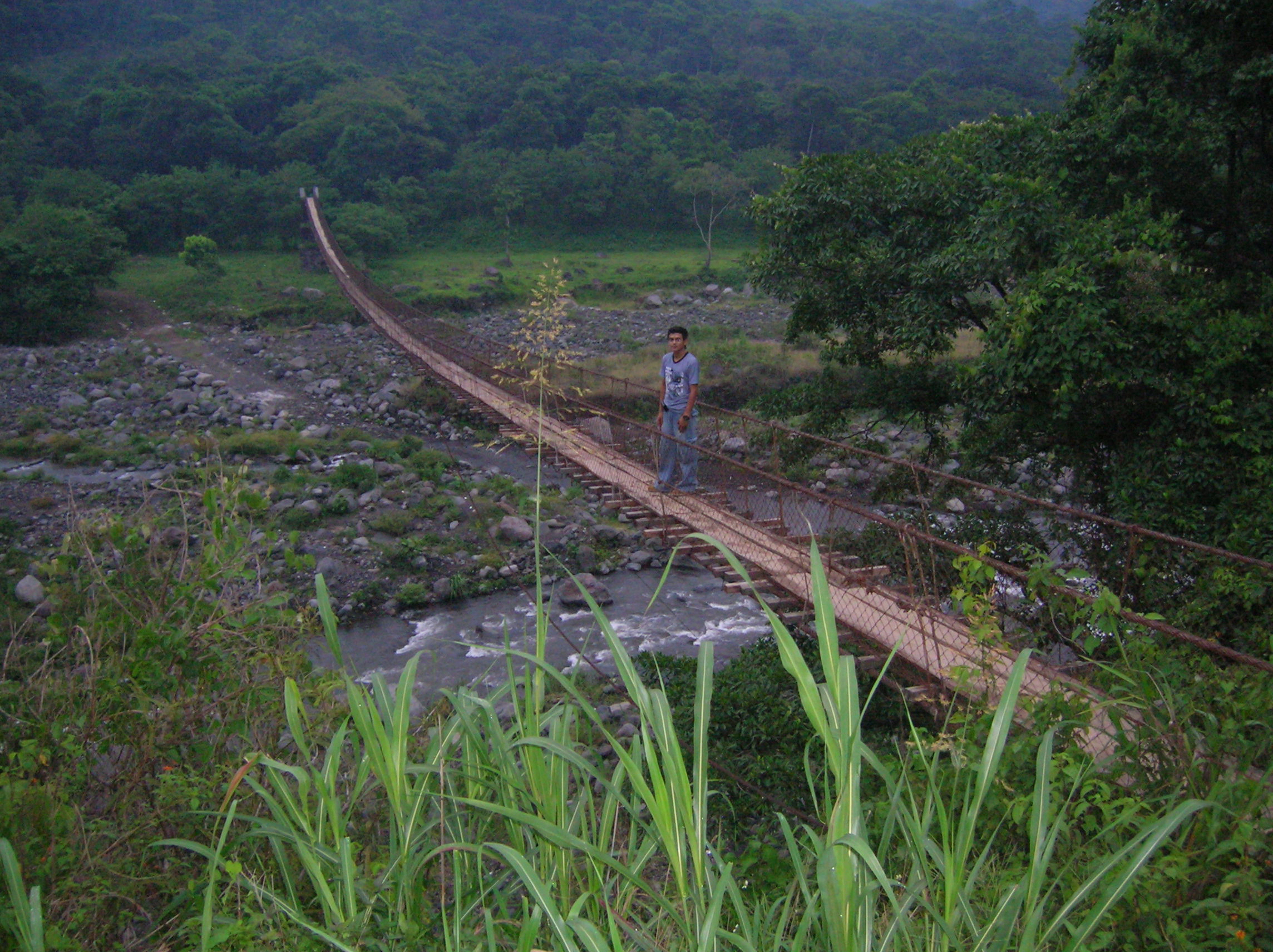
Suspension footbridge over the Rio Pantaleón, one of the principal lahar pathways from Fuego volcano. This bridge is the primary evacuation route for ~8000 people in the event of an eruption.
The afternoon rains started in earnest as we drove east from the bridge on the CA-2 Highway and passed through the Pacific Lowland city of Mazatenango. When we reached the city of Santa Lucia Cotzumalguapa, we headed north through sugar cane fields on our way towards Fuego, the second volcano I visited on this trip. Fuego has had at least 60 eruptions since the arrival of the Spanish ~500years ago which makes it among the most active volcanoes in the world. My hosts decided to drive me up the primary volcano evacuation route, a path chosen by the authorities for use in the event of an eruption by the sector’s ~ 8000 inhabitants. The route seemed pretty good as we went along mile after mile of a gently inclined dirt road flanked by agricultural lands. Then we arrived at the Rio Pantaleón, one of the principal lahar channels that descend from the ash covered flanks of Fuego volcano. There is no bridge for vehicles to cross the river ‒ only a wide spot to ford the river ‒ and fording the river is feasible only during times of low water and no lahars. For pedestrians to get across the river, there is an Indiana Jones-style suspension bridge stretching across the river valley, hovering ~20 m above the streambed. It goes without saying that it would be an ‘exciting’ crossing when there is a roaring lahar raging under the bridge beneath your feet. In the event of a real evacuation, I don’t know too many families with children (already frightened by an erupting volcano) who would feel entirely comfortable with this type of bridge crossing. Fortunately, one side of the bridge is connected to a hillside high above the river. The other end of the bridge, however, is connected to a pedestal, reached by a long flight of stairs, that is positioned on the margin of the river bed, an area that has been inundated by lahars in the not too distant past.
We carried on up the evacuation route and the road became worse and worse, passable by only high clearance 4WD vehicles. It became clear that Fuego volcano evacuees who take this route would likely have little choice but to walk since the primary form of transport (buses) would never make it on thisroad. We kept driving up the 4WD track until we passed through the towns of Morelia and Panimache, reaching the Fuego Volcano Observatory (OVFUEGO). I met the two observers there, Amilcar and Edgar, was welcomed with a real Guatemalan barbecue, and fell asleep to the sound of small eruptions from Fuego volcano.
Final installment: Fuego Volcano Observatory and donated equipment list
Part 1: The IVM-Fund and Guatemala Fundraiser
Part 2: Arrival and Day 1 in Guatemala City
 Jessica Ball is a volcanologist at the U.S. Geological Survey, researching volcanic hydrothermal systems and stability, and doing science communication for the California Volcano Observatory. She previously worked at the Geological Society of America's Washington DC Policy Office, learning about the intersection of Earth science and legislative affairs. Her Mendenhall postdoc and PhD focused on how water affects the stability of volcanoes, and involved both field investigations and numerical modeling applications. Her blogging covers a range of topics, from her experiences in academic geosciences to science outreach and communication to her field and lab work in volcanology.