
25 June 2010
Los Alamos & environs
Posted by Jessica Ball
While I was visiting Los Alamos recently, I made sure I got out of the lab to do a little hiking. Here are the photographic results:
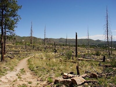
This hike was on the Quemazon trail, which starts in the western part of the town of Los Alamos. (There are a number of trails that can be accessed from the neighborhoods around the lab – even a few you can hike to get to work in the morning!) The trail makes several loops up a mesa, depending on how far you go, and gives you some great views of the area.
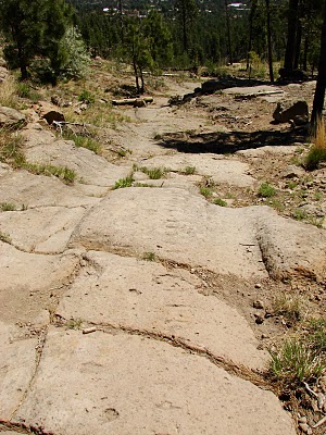
The trail itself is, in many places, worn down into the relatively soft Tshirege member of the Bandelier tuff. The volcanic tuff was erupted about 1.25 million years ago in the collapse of the Valles Caldera, and underlies much of the town. (The path on the left is used for foot and bike traffic, although it looks like something mechanical came in and roughed up the tuff on the right side.)
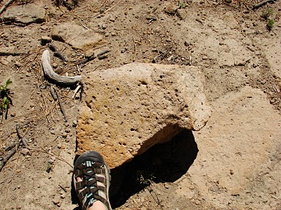
A vesicular example of the tuff:
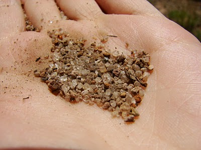
And a close-up of a hand sample. This stuff is chock-full of feldspar, and the sandy parts of the path sparkled pretty dramatically in the sun.
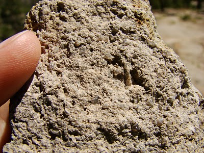
A “hand sample” of sand from the path. There’s almost more feldspar than matrix in this, though it could be because the feldspars were just collecting in the area that I happened to scoop it up from. (Some of these feldspars were iridescent, which sometimes happens with sanidine feldspar; it’s probably a safe bet that they are sanidine, which is a very common mineral in explosive volcanic rock.)
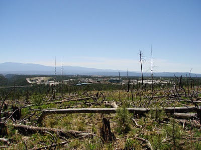
The hills above Los Alamos are unusually bare for this type of high desert, and that’s because they’re still recovering from the May 2000 Cerro Grande fire. The fire, which was started as a controlled burn, destroyed 48,000 acres of forest, more than 400 homes and part of the Laboratory in Los Alamos. (The houses that were burned in the fire were scattered all throughout the neighborhoods in town, and there were quite a few instances where one house was destroyed but another just across the street was untouched. Even now, there’s quite a bit of rebuilding still going on.)

One (minor) advantage of the fire is that it made the views of the Lab a little clearer; I can imagine that ten years ago, this shot would have been mainly taken up by pine trees, like the dark green ones further downslope. This is only a small part of the Laboratory – there are more sites elsewhere in town – but it’s the main area of office buildings and includes a research library.
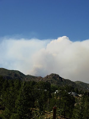
Thinking about the Cerro Grande fire made me a little nervous while I was out there, because there were a number of smaller fires burning in the Jemez Mountains to the north; fortunately, they were about 15 miles away, and not likely to threaten the town. Still, it was a bit unnerving to walk home every afternoon and see this:
I am also, it seems, allergic to the combination of burning pine trees and pine tree pollen, so it was a bad week for my sinuses.
 Jessica Ball is a volcanologist at the U.S. Geological Survey, researching volcanic hydrothermal systems and stability, and doing science communication for the California Volcano Observatory. She previously worked at the Geological Society of America's Washington DC Policy Office, learning about the intersection of Earth science and legislative affairs. Her Mendenhall postdoc and PhD focused on how water affects the stability of volcanoes, and involved both field investigations and numerical modeling applications. Her blogging covers a range of topics, from her experiences in academic geosciences to science outreach and communication to her field and lab work in volcanology.
Good eye spotting the sanidine in the area. It is pretty common in several of the tuffs I've seen from Valles. I've mainly worked with the Otowi and Cerro Toledo, but it should be in most of the Bandelier Tuff.Make sure to keep tabs on the wildfire situation. Hopefully it won't wreak havoc on much more than your sinuses.
Telling tourists at Yellowstone that the bright shiny sanidines are actually diamonds that the government doesn't want them to know about is always good entertainment value.
Excellent! I'll have to try that one sometime…
If you can find an ant hill in the area, the ants are great at picking out the sanidine crystals and making nice sparkly piles for geologists to collect. Just act fast so you don't end up with angry ants in your sample!