
20 May 2020
Edenville dam: a major dam collapse in Michigan
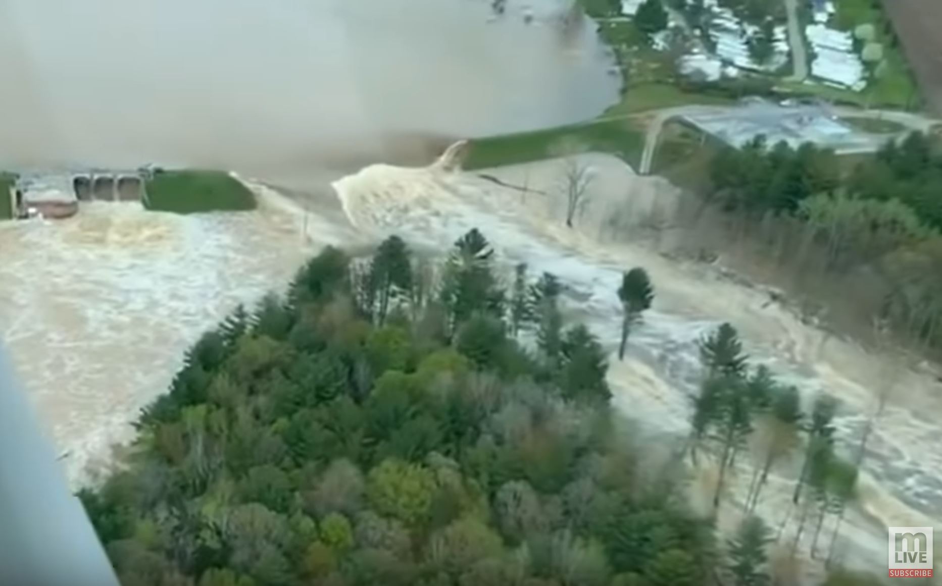
The Edenville dam collapse. Image from a Youtube video posted by MLive
Edenville dam: a major dam collapse in Michigan
In Midland County, Michigan, USA a dam collapse is underway, driven by heavy rainfall. CNBC has a good article about the ongoing accident, which is causing extensive flooding. Unfortunately, as I write, reports are coming in that a second dam, at Sanford in the same area, has also breached.
The Edenville Dam is located at 43.813, -84.376. MLive has excellent aerial footage of the breach, and the extensive downstream flooding:
.
The town of Edenville is located about 1 km downstream of the dam:-
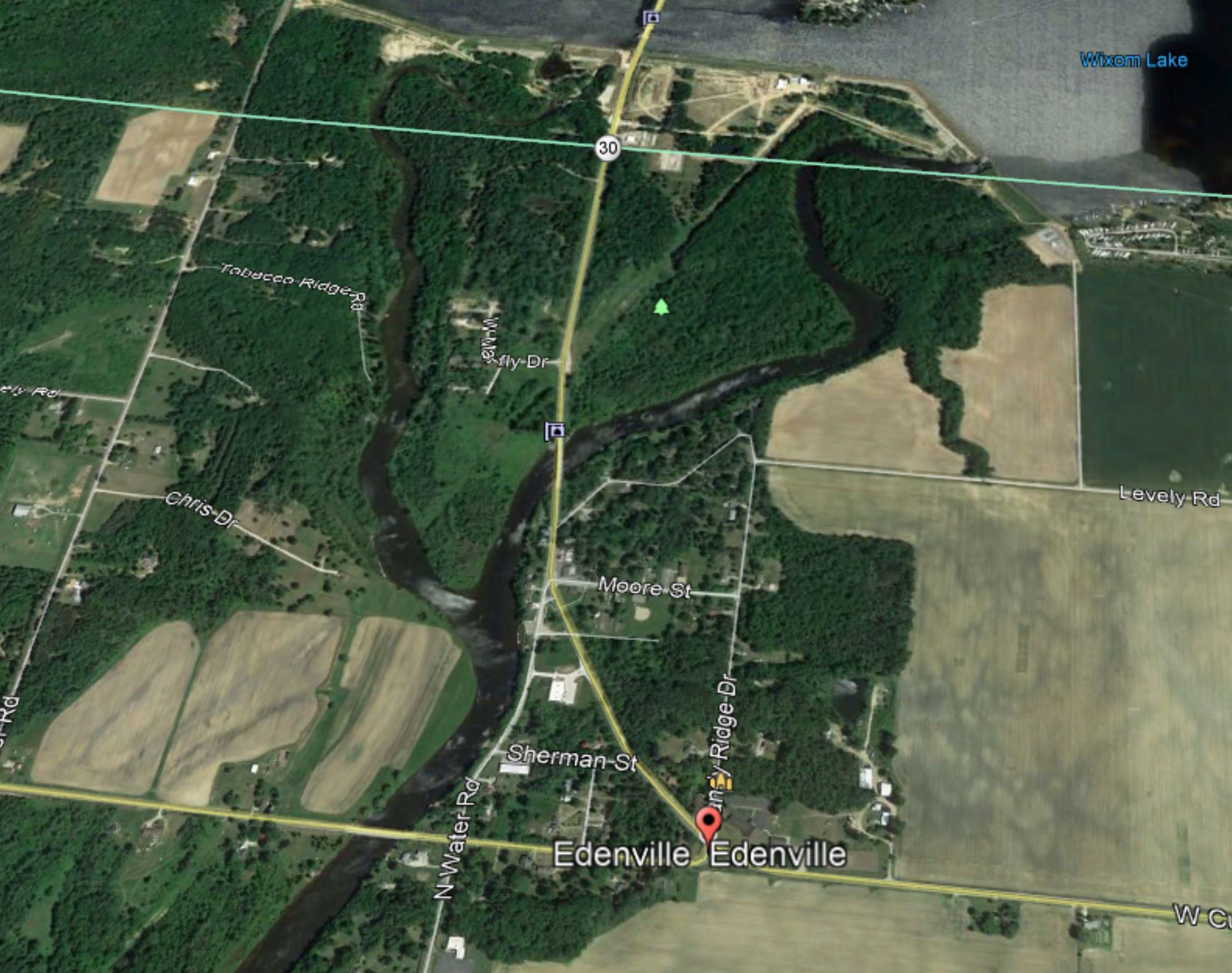
Google Earth image of the location of the Edenville Dam failure in Michigan, USA.
.
At the moment the cause / mechanism of the failure is not clear. ABC12 has a report from 2018 that the licence for the dam had been withdrawn by the Federal Energy Regulatory Commission because the structure had insufficient capacity to handle the Probable Maximum Flood. The FERC ruling is available online, and states the following:
Of particular concern is the project’s inability to pass the Probable Maximum Flood (PMF) due to inadequate spillway capacity … Currently, spillway capacity at the Edenville Project can only pass about 50 percent of the PMF.
NBC25 reports that the designs for a remediation of the hazard were being prepared, with construction anticipated in the period 2021 to 2023.
.
On reflection 1: Cyclone Amphan
Cyclone Amphan will make landfall in a few hours from now in NE India; this remains an extremely dangerous storm. As I have noted previously, although we categorise tropical cyclones on the basis of wind strength, most of the damage is typically caused by water. India and Bangladesh have well-established systems for evacuating people exposed to storm surge (although in the time of Corona Virus these will be tested to the maximum), but this storm is likely to cause substantial levels of inland damage from flooding and landslides.
.
On reflection 2: submarine landslides in the Gulf of Mexico
New research, published in Geophysical Research Letters, has detected 85 previously unknown submarine landslides in the Gulf of Mexico. Most of these landslides were triggered by the passage of seismic waves from distant earthquakes. The study suggests higher than anticipated levels of hazard to both underwater infrastructure and coastal communities.
19 May 2020
A long run out landslide from Yudi Peak in Alaska
A long run out landslide from Yudi Peak in Alaska
With thanks from me to loyal reader Hig for pointing it out, the Facebook page of Alpine Air Alaska has some stunning photographs, and a very cool video, of a long run out landslide that has recently occurred on Yudi Peak, near to Girdwood in Alaska. This is one of their images:-
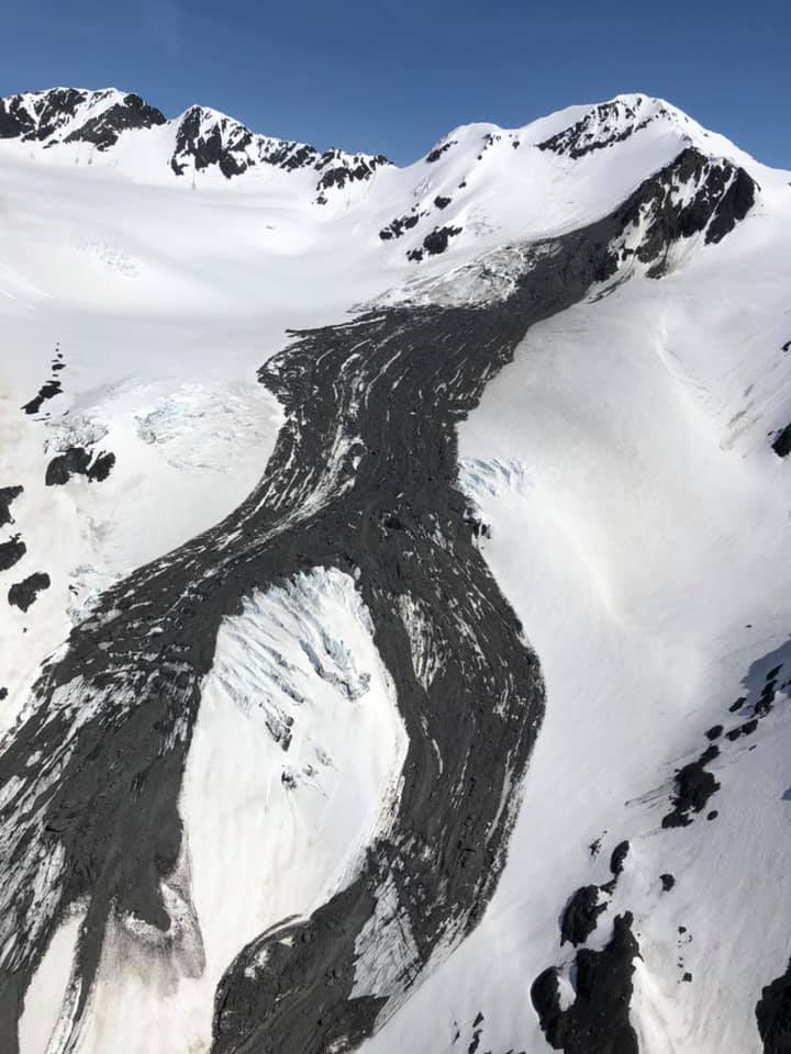
The upper reaches of the landslide from Yudi Peak in Alaska. Image from the Facebook Page of Alpine Air Alaska.
.
The crown of the Yudi Peak landslide is located at 61.03, -148.96 at an elevation of about 1430 m. It has a run out distance of about 2 km, stopping at an elevation of about 1009 m. This image, also posted to the Facebook Page of Alpine Air Alaska, shows the full length of the landslide:-
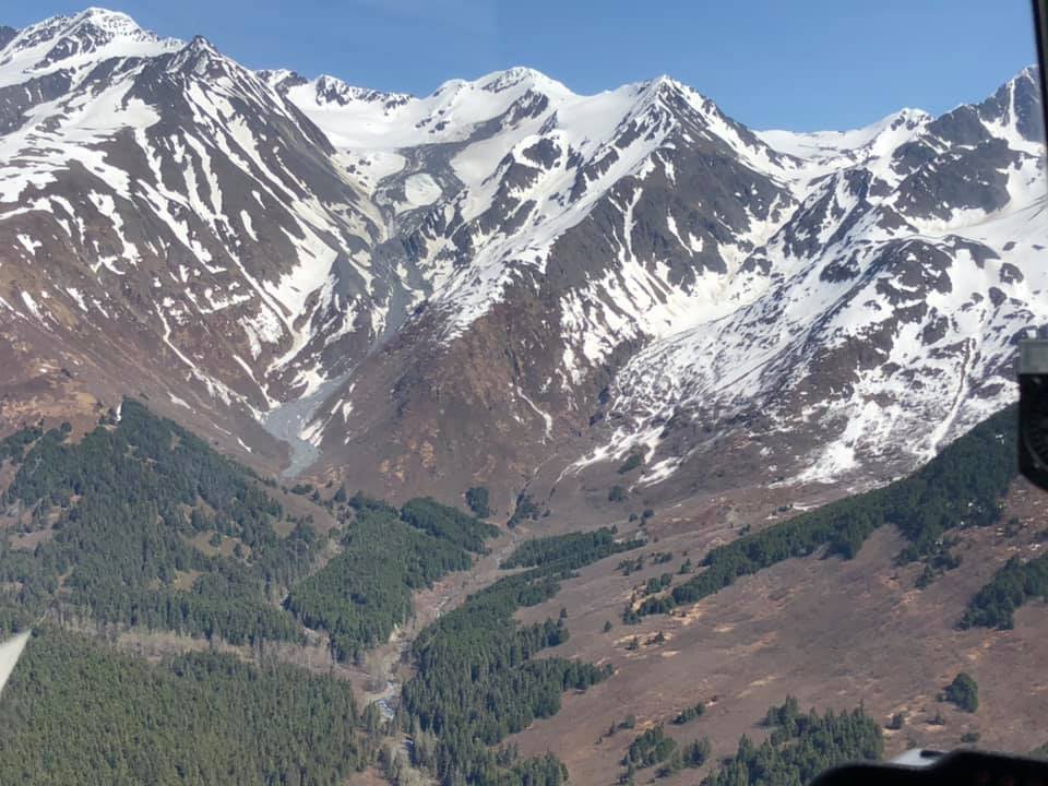
The full extent of the landslide from Yudi Peak in Alaska. Image from the Facebook Page of Alpine Air Alaska.
.
From the images, that landslide appears to have initiated as a wedge failure. The volume is not very large. but the terrain is steep and the initial sliding surface was snow and ice, providing a high level of mobility. There may have been some entrainment once the landslide reached the bedrock areas. The best view of the landslide is on a video that Alpine Air Alaska have flown of the full length of slide. It is very rare to have such good coverage of the full track of a slide.
The landslide is first visible on satellite imagery on 10 May 2020. It is not visible on an image on 6 May 2020, so it occurred sometime in that window.
It is well established that Alaska sees large landslides in the Spring, and that their increasing size and frequency is driven by global heating.
.
On reflection 1: landslide threat from Cyclone Amphan
Cyclone Amphan is now an extremely dangerous tropical cyclone, tracking northwards to make landfall, probably in West Bengal, tomorrow. Whilst it will weaken a little in the next 24 hours, it has the potential to cause very substantial levels of damage, compounded of course by the increased vulnerability of the population as a result of Covid-19. This storm will bring extreme rainfall to the hilly areas of Bangladesh, NE India and possibly E. Bhutan. The potential for severe landslides and floods is high.
The ever wonderful Save the Hills blog, which features community efforts to manage landslides in the Kalimpong area on NE India, is likely to feature some of the impacts. I await the outcome of this storm with some trepidation – expect news of landslides towards the end of the week.
.
On reflection 2: landslides from a Mw=5.2 earthquake in China
At 13:48 UTC a Mw=5.2 earthquake struck Qiaojia County in Yunnan Province, China. Xinhua reports four fatalities so far, and at least some landslide impacts:
Xinhua reporters on Tuesday morning saw rescuers approaching Yakou Village, Xiaohe Township in the epicenter of Qiaojia. Excavators are removing debris of landslides along the road.
18 May 2020
The current landslide crisis in East Africa
The current landslide crisis in East Africa
In recent months I have highlighted the increasing occurrence of fatal landslides in Africa associated with bouts of heavy rainfall. I have noted on a number of occasions that I seem to record more landslides now in this region than was the case in the past. However, this was an observation rather than a measurement, so I decided this morning to take a look at the data in more detail.
I have good quality data on fatal landslides for this region from 1 January 2004 to the present. The graph below shows the cumulative number of fatal landslides in this region from 1 January 2004 to 16 May 2020 (I have yet to update the data for the weekend just gone):-
.
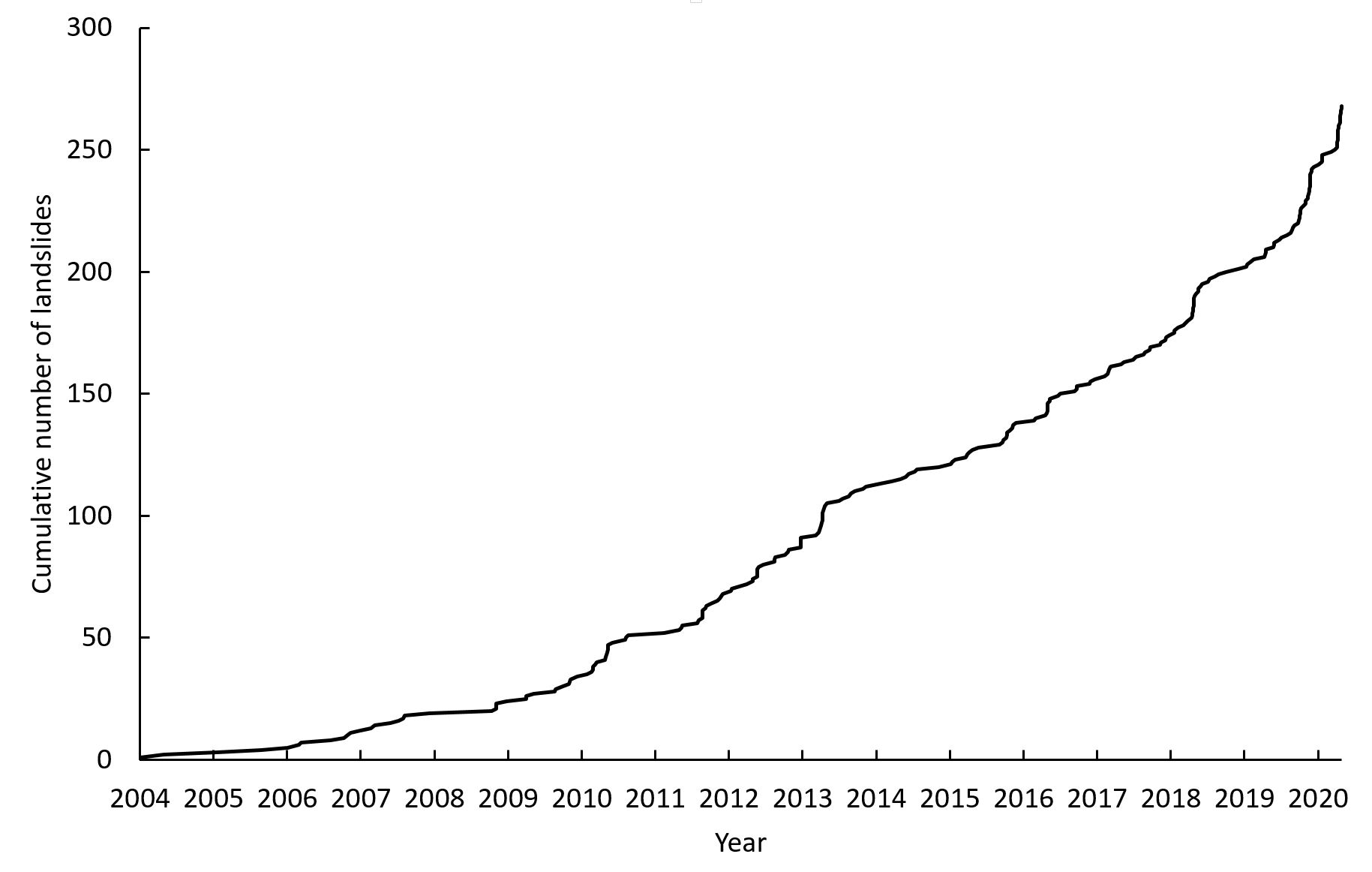
The cumulative number of fatal landslides in East Africa since 1st January 2004.
.
There is a very marked steepening of the curve in the data. In the early years of this work I recorded few fatal landslides in this region, perhaps anomalously so. From about 2008 this seems to have changed; perhaps at this point reporting from this part of the world improved, or perhaps there was an genuine increase in the number of landslides. There are a number of steps in the graph, marking periods of particularly heavy rainfall.
But from about 2018 the number of fatal landslides has markedly increased, and at the moment the curve is much steeper than it has been previously in the record. The key question is of course why?
Seasonal rainfall in East Africa is controlled by the Indian Ocean Dipole, which is the local equivalent of El Nino. The BBC Website has a good explanation of the Indian Ocean Dipole. The graph below shows an indicator of the state of the Indian Ocean Dipole, using a NOAA dataset called the Dipole Mode Index (DMI):-
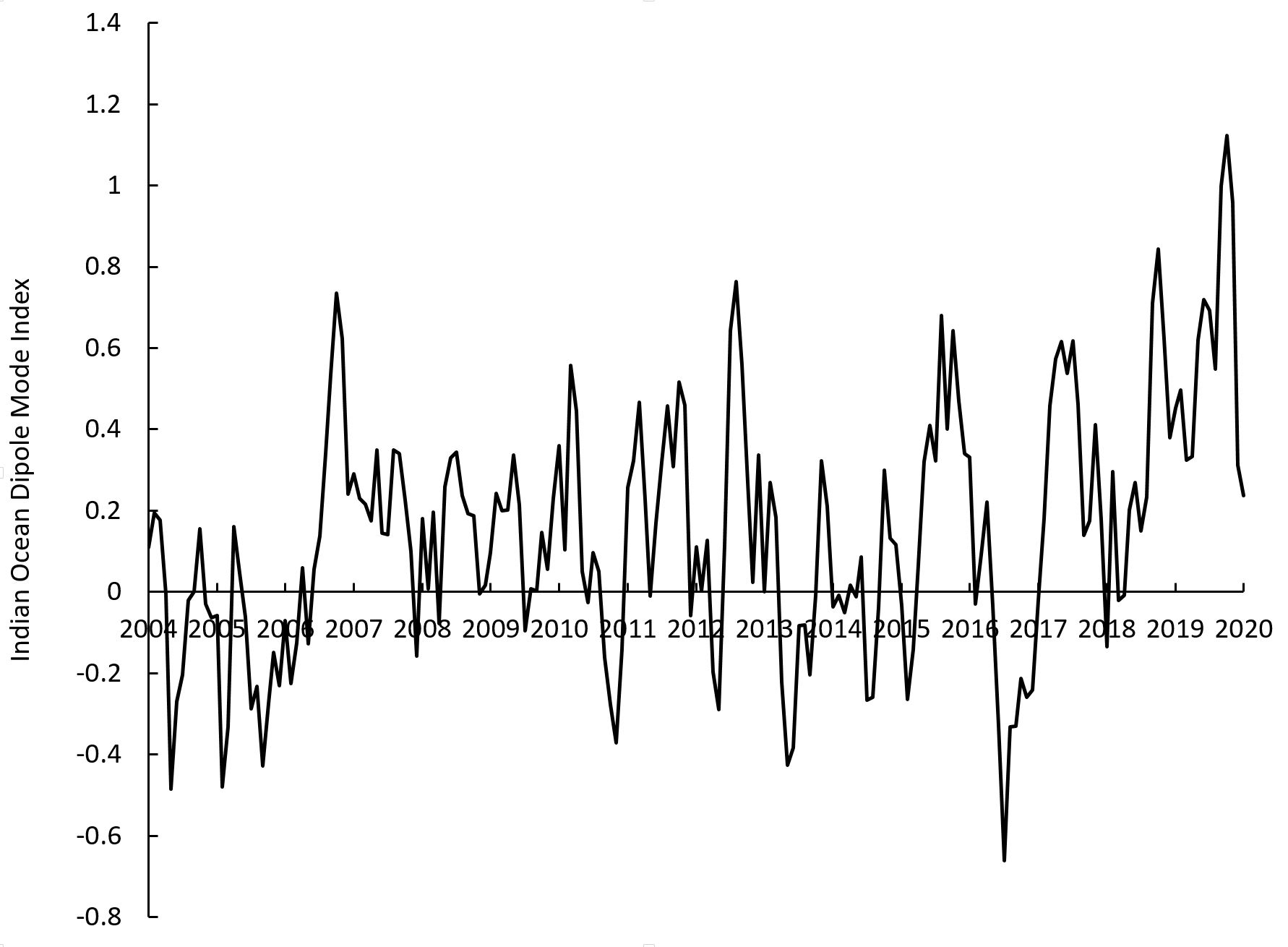
Graph of the Indian Ocean Dipole indicator, the Dipole Mode Index, which controls seasonal rainfall in East Africa. Data from NOAA.
.
In the very early years of my dataset the DMI was largely negative, which might explain the low number of fatal landslides. But what is marked here is that since 2018 the value has been positive, and indeed reached a level not seen anywhere else in the period snce 2004.
Others have suggested that the current prolonged period of heavy rainfall in East Africa might be associated with this unusual pattern in the Indian Ocean Dipole. The fatal landslide data would seem to support this view.
.
On reflection 1: More fatal landslides at Ramban
Recently I highlighted the high incidence of fatal landslides on the Srinagar-Jammu National Highway. Over the weekend two more people were killed in the infamous Ramban area.
.
On reflection 2: larger earthquakes trigger larger landslides
A new study by researchers from the USGS and NASA shows that larger earthquakes trigger larger landslides.
15 May 2020
A potential major rock slope failure above Barry Glacier in Alaska
A potential major rock slope failure above Barry Glacier in Alaska
Yesterday, officials at the State of Alaska released a statement highlighting the risks of a major rock slope failure above the terminus of Barry Glacier in Alaska. This was prompted by a letter released by a group of scientists that highlighted the problem. The scientists’ statement starts:
We, a group of scientists with expertise in climate change, landslides, and tsunami hazards, have identified an unstable mountain slope above the toe of Barry Glacier in Barry Arm, 60 miles east of Anchorage, that has the potential to fail and generate a tsunami. This tsunami could impact areas frequented by tourists, fishing vessels, and hunters (potentially hundreds of people at one time). We believe that it is possible that this landslide-generated tsunami will happen within the next year, and likely within 20 years.
The statement from the State of Alaska notes that:
The threat of a large and potentially dangerous tsunami is looming in Prince William Sound, where an increasingly likely landslide could generate a wave
with devastating effects on fishermen and recreationalists using the area, the state’s top geologist said today.
The problem is a large, creeping rock slope that shows in the order of 185 m of deformation in some places. Failure of the slope could generate a tsunami in Harriman Fiord. The landslide is quite clear on Google Earth, although the image is now three years out of date. The location is 61.152°, -148.165°:-
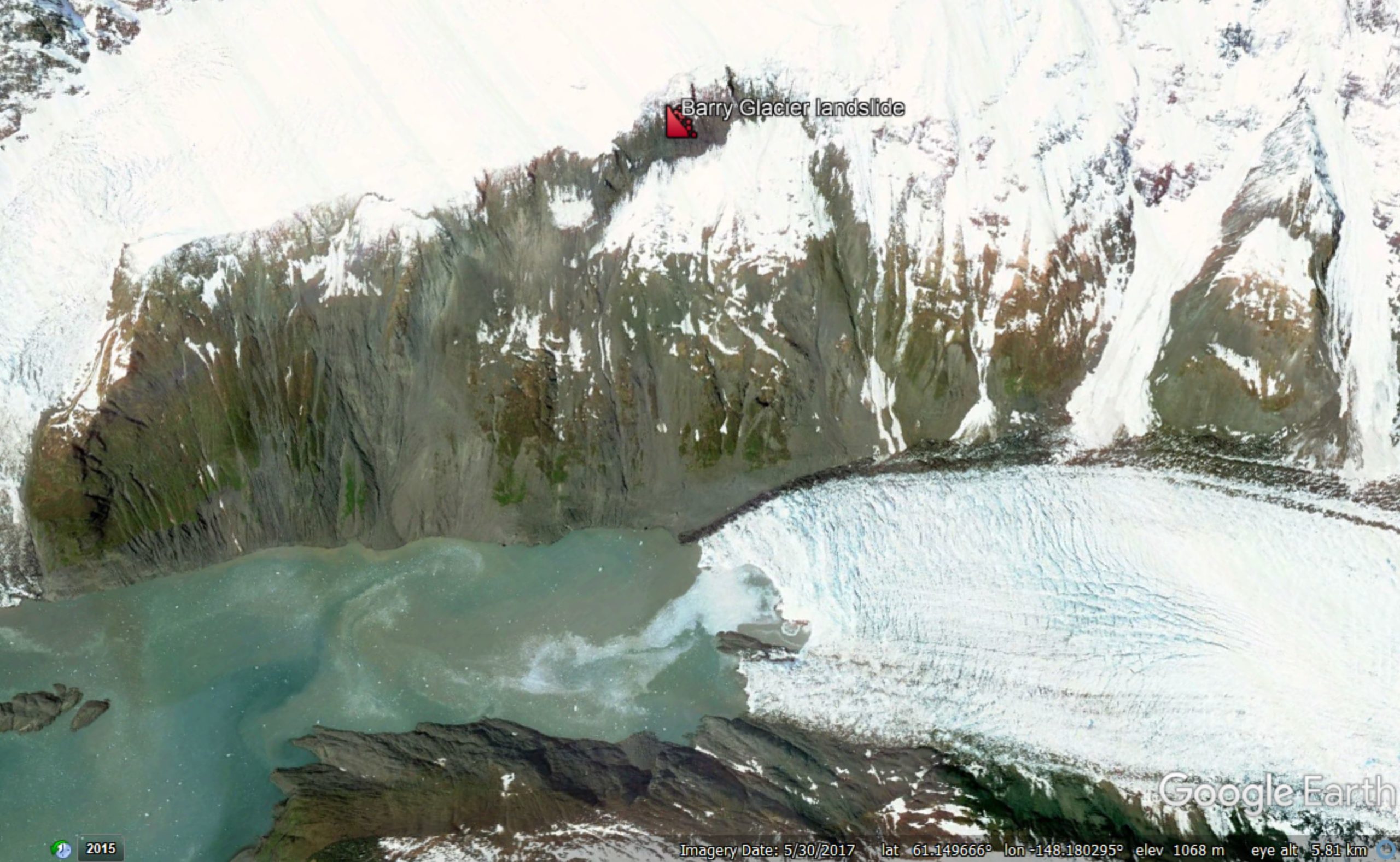
Google Earth image of the Barry Glacier landslide in Alaska. The marker shows the crown of the landslide – the scarp is evidence of the huge deformation that has already occurred on the slope.
.
This is a very large landslide – the scientific team estimate a volume of about 500 million cubic metres. Such large rock slope failures have a well documented track record of generating truly enormous local tsunami, with the Lituya Bay event in 1958 being the archetype of course. But, as I highlighted earlier this week, the behaviour of large rock masses is hard to anticipate.
In this case, there is an urgent need for monitoring, backed up by a detailed investigation of the landslide and its constituent materials. The science team has outlined an appropriate approach:-
To inform and refine hazard mitigation efforts, we would like to pursue several lines of investigation: Detect changes in the slope that might forewarn of a landslide, better understand what could trigger a landslide,and refine tsunami model projections. By mapping the landslide and nearby terrain, both above and below sea level, we can more accurately determine the basic physical dimensions of the landslide. This can be paired with GPS and seismic measurements made over time to see how the slope responds to changes in the glacier and to events like rainstorms and earthquakes. Field and satellite data can support near-real time hazard monitoring, while computer models of landslide and tsunami scenarios can help identify specific places that are most at risk.
The State of Alaska is taking this problem seriously. Its statement indicates that they will take a proactive approach:
The Division of Geological and Geophysical Surveys looks forward to cooperating with interested agencies and institutions to monitor the situation. One important step would be to monitor movement of land in the area by placing solar-powered GPS monitors on the potential landslide area to detect increased rates of movement that frequently precede catastrophic landslide failures.
The problem is being reported in the media in Alaska. Responding to these types of problems is challenging at the moment because of the Corona Virus crisis, but this does require attention. Failure is not inevitable, but the effects could be catastrophic.
.
On reflection 1: the 2019 fatal landslides database
Many thanks for those who have contacted me with corrections to the 2019 fatal landslide database. I’ll try to get a revised version online in the next few days and will highlight it here.
.
On reflection 2: Landslide problems in Kenya deepen
Kenya has been struggling for weeks with massive landslides caused by heavy rainfall. The problems have now deepened as a landslide has destroyed the water supply to the Kangemi slum on the outskirts of Nairobi. This is home to about 20,000 people.
Acknowledgement
Many thanks to Hig – Dr Bretwood Higman of Ground Truth Alaska – for keeping me updated about the Barry Glacier landslide.
14 May 2020
The 2019 fatal landslide dataset
The 2019 fatal landslide dataset
Yesterday I posted a map of the events in my fatal landslide dataset. In the post I provided the map as a diagram and as a dynamic Google Map that you can use to examine any given area. I posed the question as to whether it would be helpful if I made this data available online. The resounding reply was yes.
So, I have put the 2019 fatal landslide dataset into a Google Sheet (the equivalent of Excel) and have made this available. I summarised this data in a post a few weeks ago, although note that there have been some minor changes since then as I have refined the dataset. Such data is not static as I discover more events, or am able to provide better estimates. I should point out that the 2004-2017 dataset is available online as a GIS tool.
I have two motivations for posting this data:
- In the spirit of an age of open data I’m keen to share the information, and am eager for it to be used. I’m happy for it to be incorporated into research, to be exploited for teaching (especially now that we’re all having to teach largely online) and to be used by practitioners. I would ask only that you cite the two papers that I have listed at the foot of this post.
- I’m also keen to have corrections and/or additions. There are uncertainties in this sort of data, of course, and you may well understand better than do I as to whether I have recorded events correctly. I’m particularly concerned that I miss events in Latin America (most particularly in Central America and in countries such as Venezuela – see below), and I worry that I capture far fewer events in China than was the case in the past.
If people are able to provide corrections then I will make the improved data available. The Google Sheet itself is locked (i.e. you cannot change the online data).
The spreadsheet should be straightforward. I should explain a few columns:
Column d: this is the pentad data that I sometimes use to plot graphs. It divides the year into 73 blocks of five days, so that pentad 1 is 1 to 5 January, pentad 2 is 6 to 10 January, etc. Plotting data like this makes it much easier to compare between years
Column j: this is an estimate of the accuracy of the location data, suing the code given at the top of the spreadsheet. You will see that for a small number of locations I do not have sufficient information to plot a meaning location.
Columns o and p: I separate fatalities and injuries from landslides triggered by earthquakes from those from other causes, simply to ease the analysis of the data.
Column q: This is the cumulative number of landslide fatalities for the year, excluding events triggered by earthquakes
Column r: This is the cumulative number of landslide events for the year, excluding events triggered by earthquakes
Column t: Sometimes reports identify a primary trigger for the event (recorded in column s) but also a secondary factor (recorded in column t).
The data does allow you to do some quite cool stuff, such as demonstrate that it is the western (mountainous) side of Colombia that is affected by landslides, but it also asks the question as to whether I am missing similar events in in Venezuela and Ecuador?
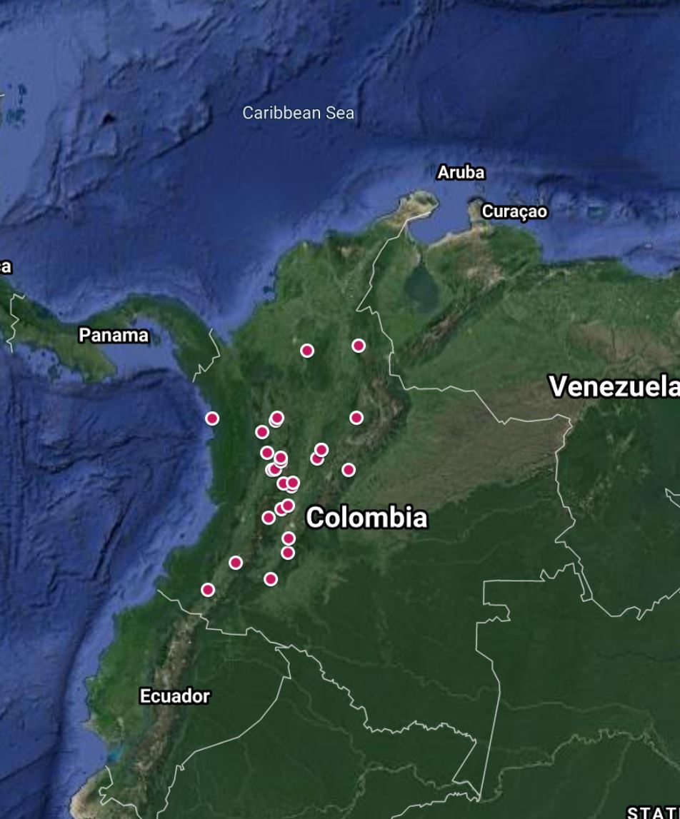
The distribution of landslides in Colombia in the 2019 fatal landslide dataset.
As always I welcome your thoughts.
.
On reflection
A rather spectacular bridge failure has been induced by a landslide at Cinyiru in Banten Province in Indonesia. The report suggests that “We have dispatched a backhoe and construction workers to repair the bridge, so that cars can again ply on it.” I think that is quite optimistic:-
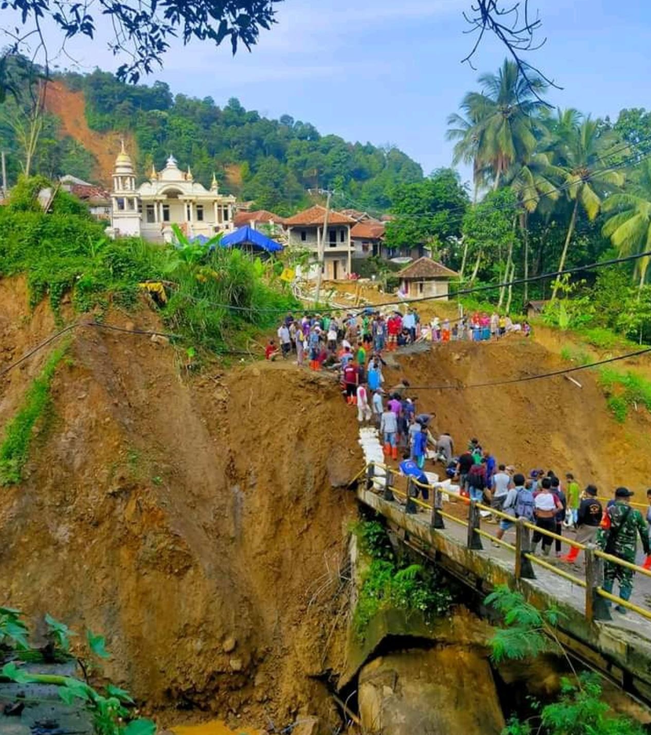
A landslide in Cinyiru, Indonesia, via Twitter. Note the landslides behind the village.
.
References
Froude, M. J. and Petley, D. N. 2018. Global fatal landslide occurrence from 2004 to 2016. Natural Hazards and Earth System Science, 18, 2161-2181, https://doi.org/10.5194/nhess-18-2161-2018.
Petley, D.N. 2012. Global patterns of loss of life from landslides. Geology 40 (10), 927-930.
13 May 2020
A map of 2019 fatal landslides
A map of 2019 fatal landslides
One of my tasks during lock down has been to geolocate the 2019 fatal landslides. This is a non-trivial job given the number of events, and in many cases the ambiguity in terms of the reported locations in the news media. But it does allow the global and regional maps to be compiled.
So here is the map of the 2019 fatal landslides, as recorded in my fatal landslide database:-
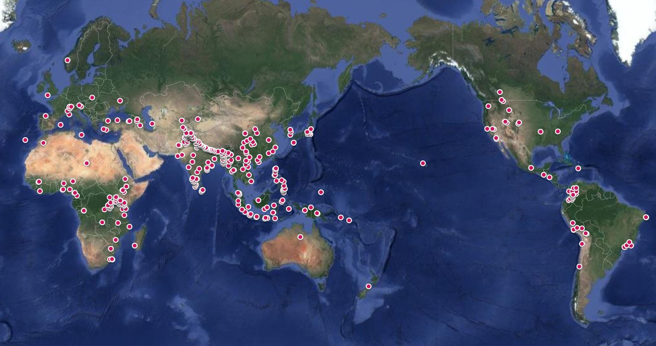
The 2019 fatal landslides map.
.
Every dot represents a landslide that killed at least one person. All fatal landslides are depicted, including those triggered by rainfall, seismic activity, mining and construction. I have made this map available online. Please be careful with over-interpreting the locations when zoomed in. In many cases it is only possible to map the landslides within a few kilometres, so very detailed maps have low reliability.
For those who read my blog regularly, or who have read my papers, there is much about this map that is familiar – the huge concentration in Asia, and the clusters in Brazil and Colombia for example. The abnormal element in 2019 is the high concentration in East Africa. I have always recorded fatal landslides in this area, but 2019 saw far more than is usual. Unfortunately 2020 is continuing that pattern, driven once again by abnormally heavy rainfall.
It is interesting to examine the 2019 fatal landslides in South Asia, which remains the global hotspot for these events:-
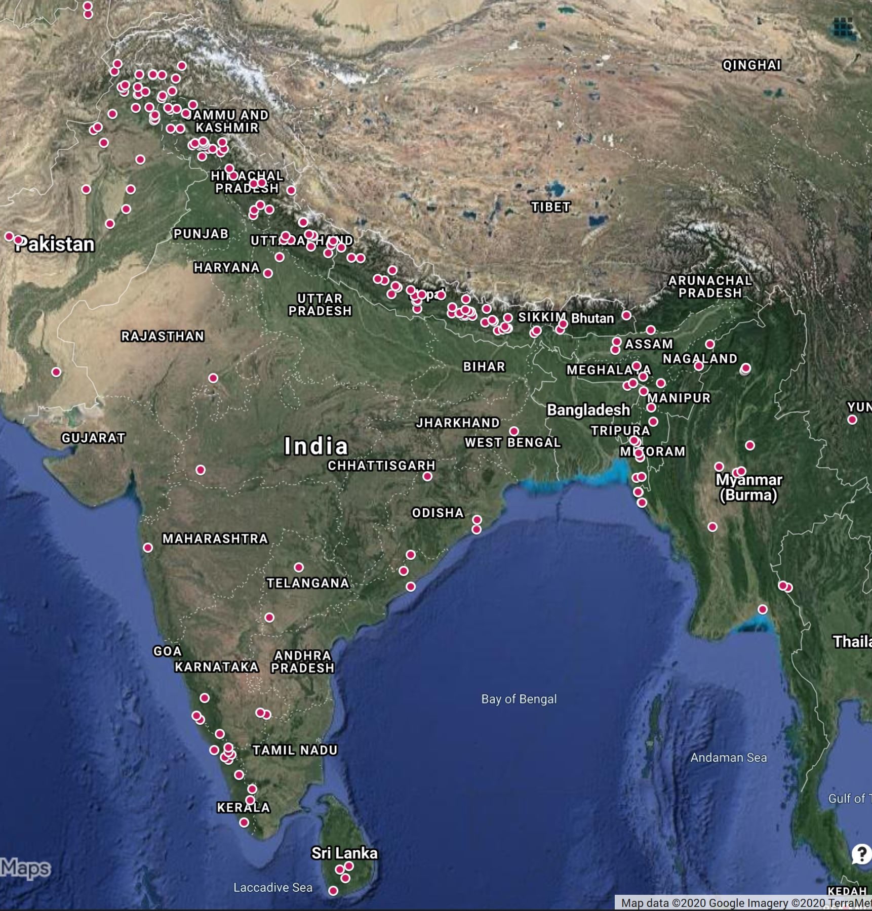
The 2019 fatal landslides map for South Asia.
.
The concentration of landslides along the southern edge of the Himalayas is clear, though Pakistan, India Nepal, Bhutan and Bangladesh. There was a particularly large number in northeast Pakistan and in the Kashmir area of India, as well as the smaller concentration in the southwest of India. We are about to enter the 2020 summer monsoon season in South Asia, with forecasts of heavy rainfall in for example Sri Lanka. The pattern of monsoon induced disasters in 2020 is going to be complex, not least because of increased vulnerability as a result of Covid-19.
I have been pondering whether to post the full 2019 dataset online as a Google Sheet, in order to make the information available more widely and to allow people to provide better information. If you would find this useful then please let me know.
On reflection 1
National Geographic has a very interesting article about the discovery of the remains of people killed by a tsunami about 1000 years ago in Tanzania in East Africa. It is likely that this tsunami was triggered by a distant large earthquake. The underpinning research has been published in Geology.
On reflection 2
The Standard reports that another large landslide has occurred in West Pokot, Kenya, close to the landslides last month that caused extensive damage. This most recent event, at Solion in Muino, has rendered 40 families homeless.
12 May 2020
The Váráš rock slope deformation in northern Norway
The Váráš rock slope deformation in northern Norway
An epic and very elegant paper has just been published in the journal Landslides (Vick et al. 2020) that examines nine rock slope deformations in Troms County, northern Norway. The aim of the work is to review styles and mechanisms of deformation. In so-doing, the article provides some fascinating examples of ongoing rock slope deformation in Norway.
Studying these large rock slope deformations is far more than an academic exercise – some of these landslides transition to full, catastrophic failure. Such events are extremely dangerous, involving large volumes and high velocities, and have the potential to induce tsunamis where they fail into fjords. Unfortunately, at present our ability to anticipate which of these large structures will transition for full failure remains poor. As such this is a very welcome piece of work.
One such example featured in Vick et al. (2020) is the Váráš rock slope deformation, located in the Signaldalen valley. This landslide can be seen clearly in Google Earth imagery – the location is 69.137° 20.103° is you wish to take a look. I have marked the present crown of the landslide in the image below:-
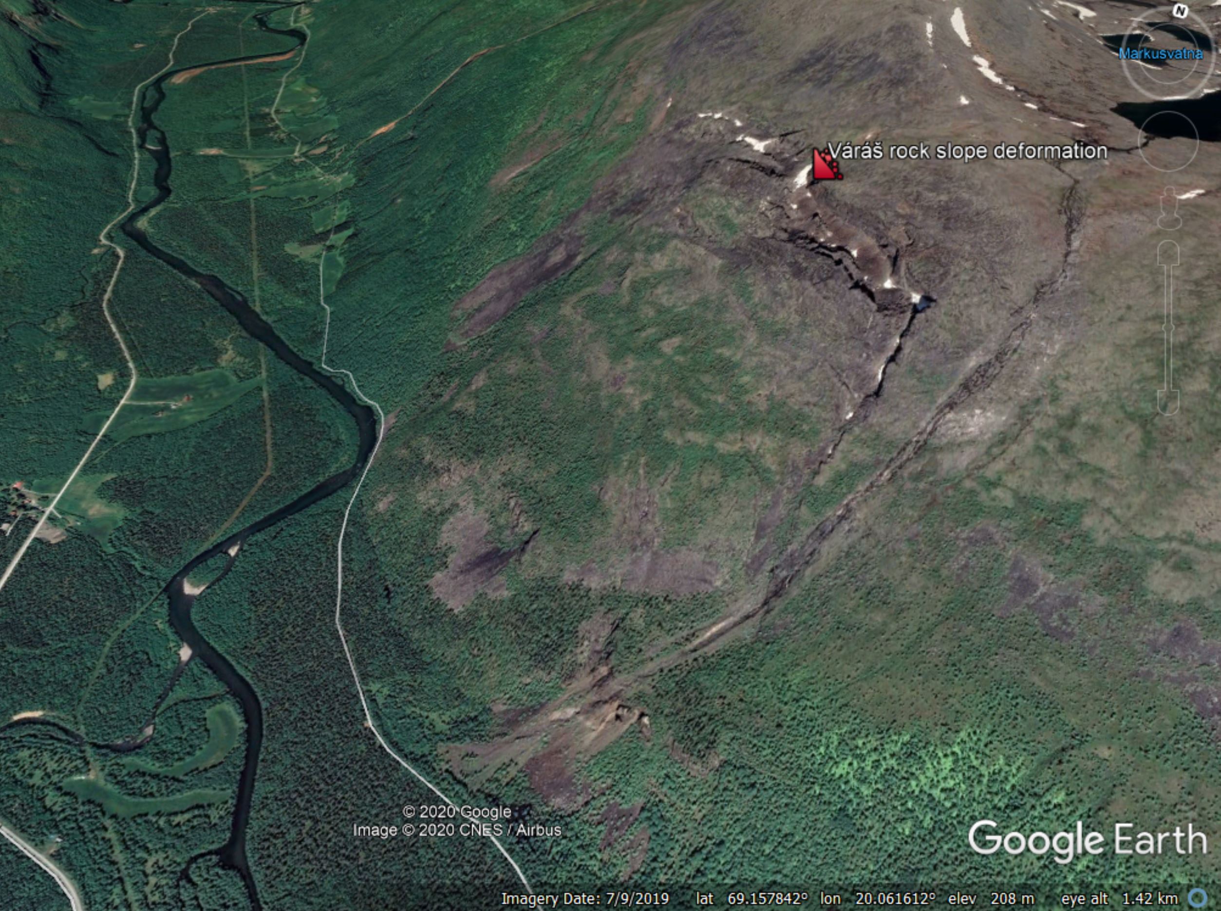
The Váráš rock slope deformation in Troms County, northern Norway, as shown in Google Earth.
.
Vick et al. (2020) provide a very clear interpretative cross-section of the landslide:-
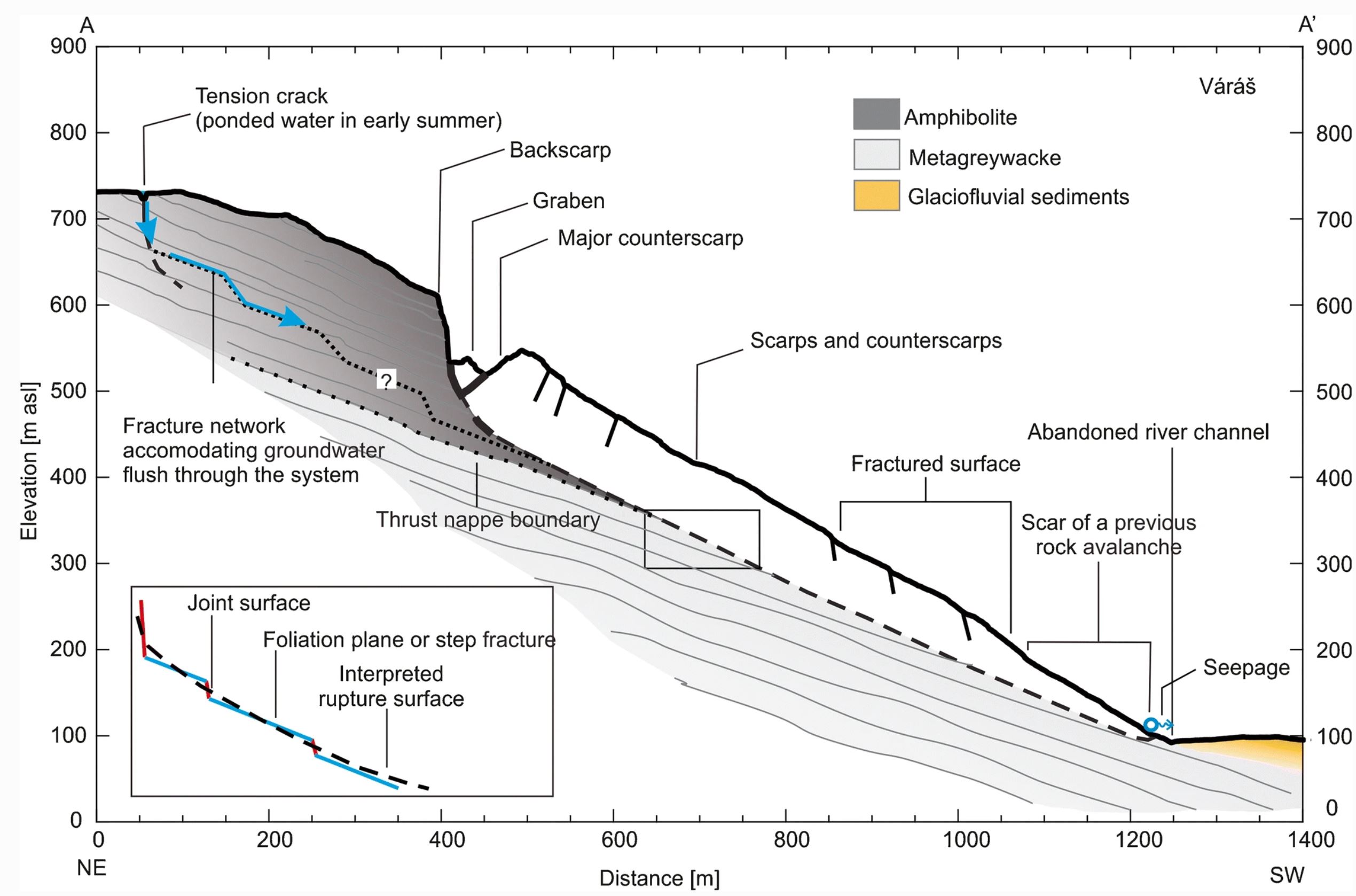
Cross-section through the Váráš rock slope deformation in Troms County, northern Norway, from Vick et al. (2020).
.
As the diagram shows, this is a large failure with about 85 m of accumulated deformation in the large graben at the rear scarp. The slide is around 100 m deep near to the crown.
The authors indicate that two failure scenarios are being considered. In the first, the whole of the rock mass fails, which would involve a volume of about 70 million cubic metres. In the second, a much smaller mass at the northern / western end of the landslide (the far end from my Google Earth image) fails, which would involve a volume of about 1.3 million cubic metres. This would still be a very large landslide. Fortunately the location is remote, so the risk to life and property is not high.
The Váráš rock slope deformation has been monitored since 2010, and Vick et al. (2020) have also used InSAR to look at the current pattern of movement. Slopes such as this are well-suited to the InSAR technique, which indicates that the larger mass is creeping slowly, whilst the smaller mass might be more active but still shows movement rates that are quite slow (typically 5 – 15 mm per year at the scarp in the line of sight direction for the InSAR).
This landslide highlights a fascinating aspect of landslide research and practice in high mountain areas. Very large rock slope deformations are common, and history tells us that they have the potential to become catastrophic failures. On first inspection these landslides look deeply alarming. However, in any given year very few actually fail, and indeed some never do so. Thus, managing the risk is key. Fortunately, with techniques such as InSAR we have a rapidly improving set of tools that allow these slopes to monitored appropriately, permitting the risk to be managed. This will get even better over the next decade or so.
On reflection
Scientific American has an excellent opinion piece by Robin Bell and Lisa White on the need for greater diversity in the Geosciences. This quotation hits the nail on the head:
However, we don’t have the right people at the table to address the biggest scientific questions we face, from how our climate is changing to when earthquakes happen. Almost 90 percent of geoscience doctoral degrees in the United States are awarded to people who are white, and faculty of color hold fewer than 4 percent of tenured or tenure track positions in top 100 geoscience departments.
This lack of diversity means we are missing those who could help us find solutions. It means we may not be considering all people and communities when seeking ways to adapt to our changing planet, save lives and deal with costly natural hazards.
Reference
Vick, L.M., Böhme, M., Rouyet, L. et al. 2020. Structurally controlled rock slope deformation in northern Norway. Landslides. https://doi.org/10.1007/s10346-020-01421-7.
11 May 2020
Waterford, New York: a large, damaging landslide
Waterford, New York: a large, damaging landslide
An unexpected landslide at Waterford in New York state in the United States last week threatened a number of houses. There are many news reports about this event, which will have been devastating to those living in the vicinity. The best set of images that I have seen were collected by Jim Franco using a drone, and posted to Twitter:-
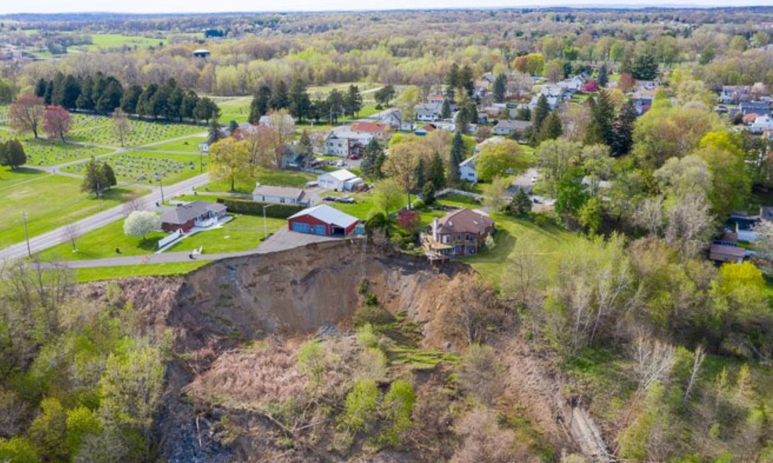
The landslide at Waterford in New York. Image by Jim Franco, posted to Twitter.
The landslide at Waterford in New York. Image by Jim Franco, posted to Twitter.
.
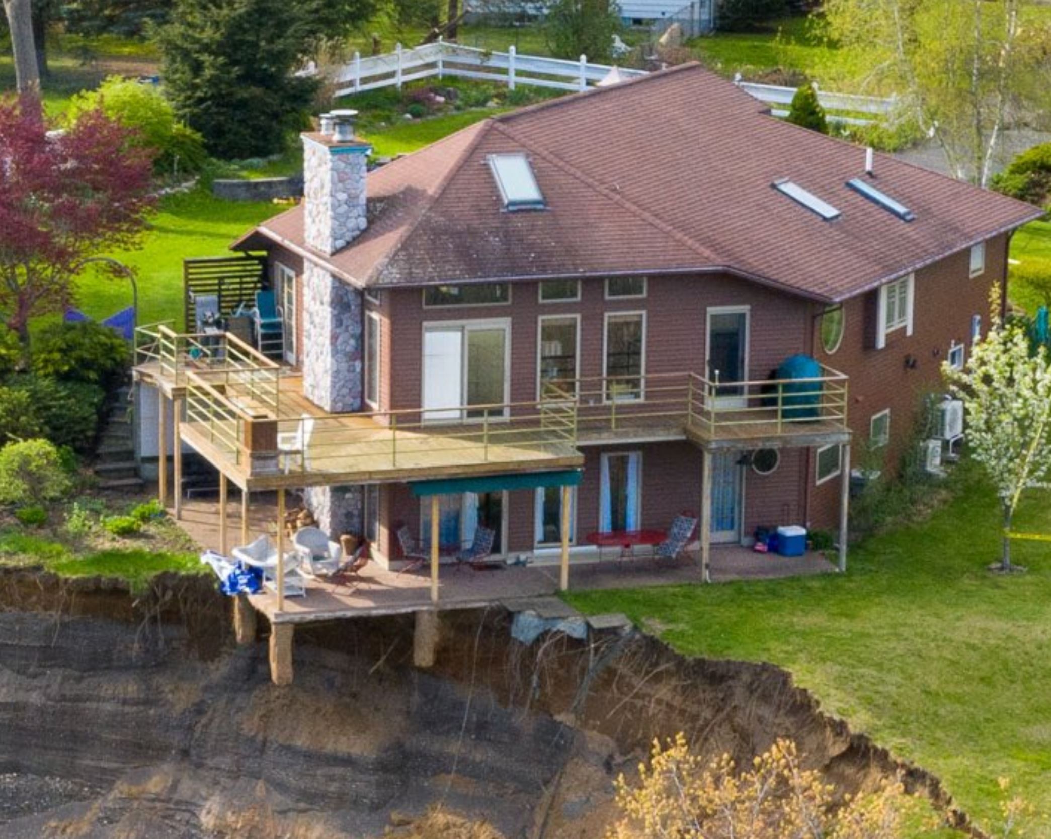
Unfortunately the rear scrap of the landslide continues to undergo retrogression, with up to 2 metres having been lost since the main failure, causing collapse of the decking. Local officials have noted, rightly, that stabilising the land is going to be a major challenge. The materials that form the landslide appear to me to be complex fluvioglacial deposits, which will be prone to erosion.
The image below provides a good sense of the whole of the failure:-
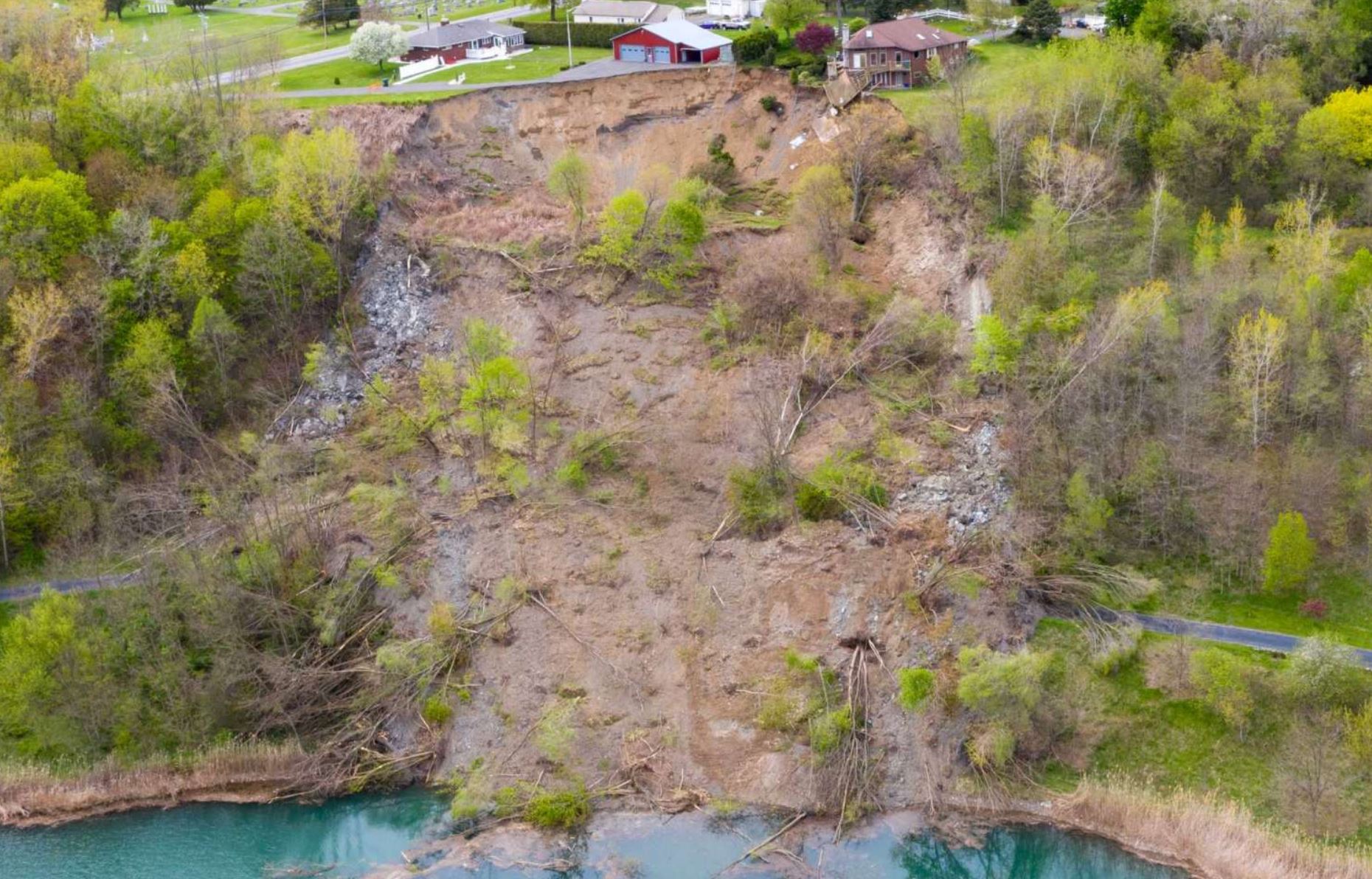
The landslide at Waterford in New York. Image by Times Union.
.
Note that whilst it might appear that the landslide is on the outside of the bend in the river, this is not the case. The water at the toe of the slope is a small lake. Given that the landslide was not triggered by rainfall, the cause of the failure is somewhat unclear.
The location of the landslide is 42.799, -73.680. The Google Earth image below was collected in June 2018. There is nothing that is immediately obvious here that appears to indicate that a failure was likely, although the dense vegetation makes interpretation very difficult:-
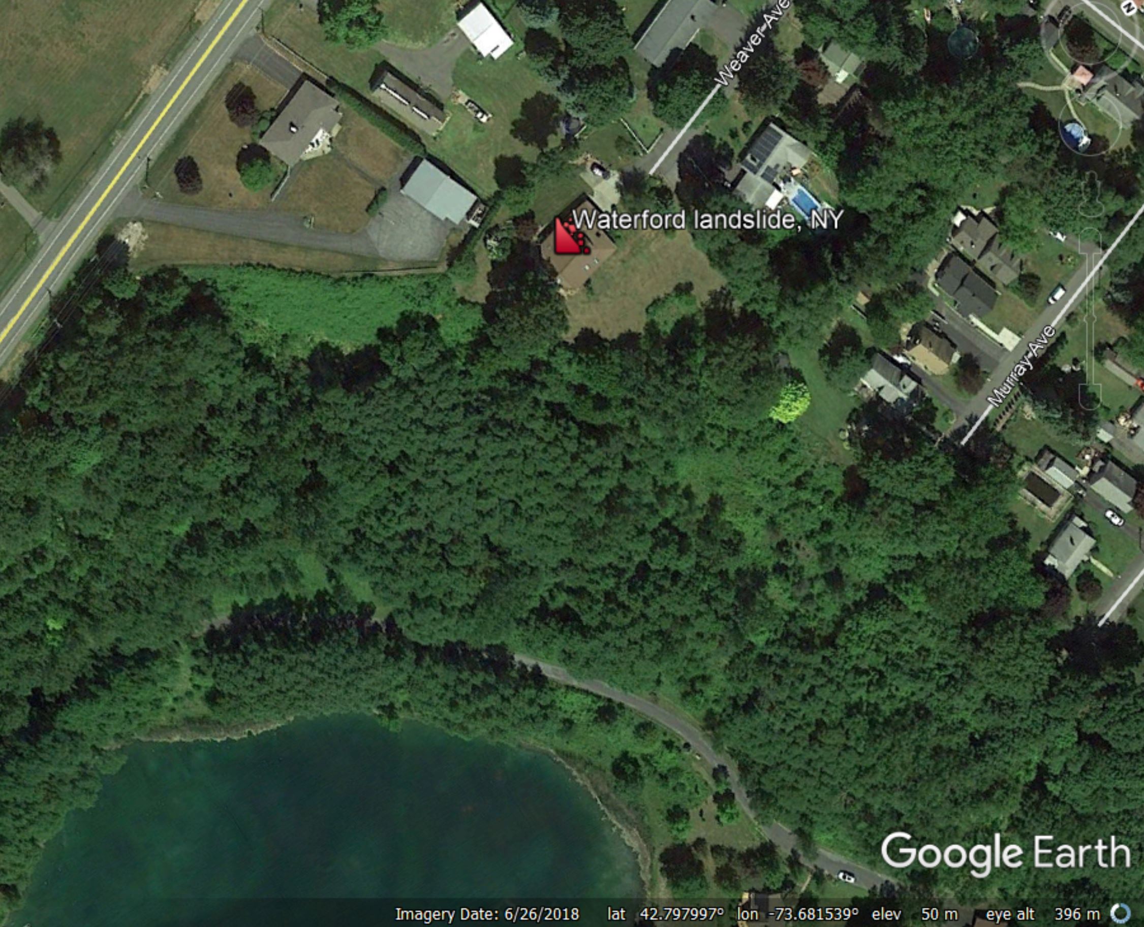
A Google Earth image of the site of the landslide at Waterford, NY. The marker is on the property that is nw endangered by the landslide.
.
On reflection
Rainfall across Africa continues to cause high levels of loss from floods and landslides. In Rwanda, dozens of people have been killed, including eight members of a single family in a landslide at Gakenke. In Kenya, landslides have affected a number of areas, whilst three people have been killed by a landslide in Uganda. In Ethiopia, 12 people were killed in yet another landslide.
7 May 2020
Planet Labs high resolution image of the Chesegon, West Pokot landslides
Planet Labs high resolution image of the West Pokot landslides
Last week I posted about the devastating channelised debris flows that caused large numbers of fatalities in the vicinity of Chesegon, West Pokot in Kenya on 17 April 2020. This is only the latest set of such events in this region, which appears to be struggling under the combined impacts of unusually intense rainfall events, land degradation and a highly vulnerable population. My friends at Planet Labs have once again gone the extra distance to collect a high-resolution SkySat image of the impacts on this area. My thanks to them, and in particular to Rob Simmon, for collecting and processing the image.
The image below was captured on 30 April 2020, a little under two weeks after the landslides:-
The 17 April 2020 Chesegon, West Pokot landslides. Planet Labs SkySat image captured on 30 April 2020. Copyright Planet Labs, used with permission.
.
The area affected by these landslides is very large, so the image inevitably captures only a part of it. The landslides were clearly devastating. The heavy population density of this area can be seen clearly; living close to the channels as these debris flows swept down would have been terrifying.
The greatest danger with these types of landslides lies when they sweep out of their channels to inundate inhabited areas. There are lots of examples of this style of behaviour in the Chesegon landslides. The image below shows a location where this has occurred twice, for example:-
Detail of the 17 April 2020 Chesegon, West Pokot landslides. Planet Labs SkySat image captured on 30 April 2020. Copyright Planet Labs, used with permission.
.
The debris flows have inundated a large area. At the downstream (eastern) end they have inundated some properties, which remain standing with their roofs on. We should not be lulled into thinking that the inhabitants will have escaped though. In channelised debris flows fatalities often occur when flows enter properties, and in doing so block exit routes such as doors and windows. Those who are lucky enough to escape are often swept off their feet by the flows.
To date these rains across Kenya have killed 194 people in landslides and floods, including the impacts in the Chesegon area, and they are forecast to continue for several more weeks. Unfortunately, more such landslides could ocur in this rainy season, and in future years. An article in The Standard in Kenya highlights extensive pre-failure deformation on slopes across a large area. In one case the tension crack is reported to be 10 km long. There is an urgent need to understand what is occurring on these slopes, and why, and to assess the risk, but I fear that landslides in Kenya will appear on this blog again in the coming years.
.
On reflection 1: Day 4 of the EGU General Assembly online
It’s a bumper day of landslide sessions today:
Displays Chat Thu, 07 May, 10:45–12:30
.
On reflection 2: dams and erosion
Massive erosion on the Coca Rover in Ecuador is being linked to sediment management for a major hydropower project.
.
Reference
Planet Team (2020). Planet Application Program Interface: In Space for Life on Earth. San Francisco, CA. https://www.planet.com/
6 May 2020
The Srinagar-Jammu National Highway:- India’s “killer highway”
The Srinagar-Jammu National Highway:- India’s “killer highway”
DW has a very nice article online about the Srinagar-Jammu National Highway, the main transportation route into the mountainous area of Kashmir in the northwest of India. This 270 km long road, which passes through steep, unstable terrain, regularly appears in my landslide fatality database, especially in the months of the summer monsoon. The article notes that the rate of deaths on this road is extraordinarily high, surpassing that of the oft-reported conflict in Kashmir:
In 2019, for instance, violence in the Kashmir valley killed 366 people, whereas accidents on the highway claimed at least 447 lives. “There were at least 252 deaths in and around Udhampur on the northern belt of the road and 195 on the southern belt of Ramban,” said Liaqat Ahmad, a traffic official working in the Kashmir Valley.
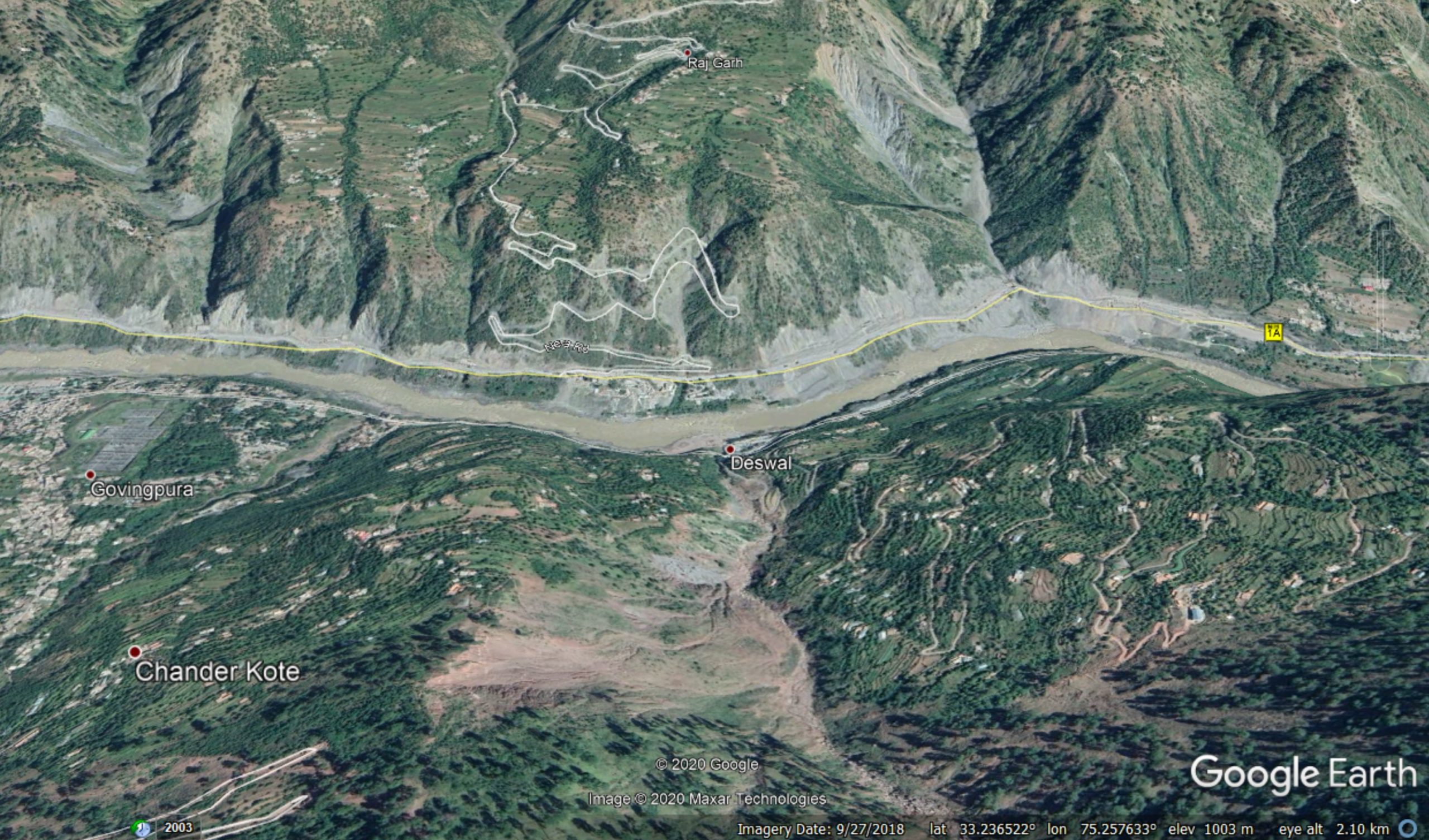
There are a variety of reasons for these losses of course, not least road traffic accidents, which are a dreadful problem in South Asia. But landslides are a major cause of loss. The scale of the problems on this road can be seen on the Google Earth imagery of the area:-
Google Earth imagery of landslides on the Jammu-Srinagar National Highway in the vicinity of Ramban.
.
This image lies just to the west of Ramban, one of the most hazardous part of the Srinagar-Jammu National Highway – this image is at 33.237, 75.258. This is a landscape with many naturally occurring landslides, but the image also shows how poor road engineering and maintenance has destabilised the slopes.
There may be something more subtle here too though. Is the valley following a fault? If so, we would expect to see a higher incidence of landslides than in the surrounding terrain. There are hints in the image that this might be the case. The road is certainly very close to the major fault systems that mark the southern edge of the Himalayan tectonic collision.
A major shallow earthquake in this area, similar to that of the 2005 Kashmir earthquake in Pakistan, would lead to catastrophic landsliding along this road.
.
On reflection 1: Day 3 of the EGU General Assembly
There are two good online sessions at the EGU General Assembly today, with a superstar set of convenors:
Displays Chat Wed, 06 May, 08:30–12:30
Unfortunately my day job, especially in the time of the virus, makes it hard for me to join these sessions.
.
On reflection 2: The depressing toll of landslides related to mining continues to increase
Depressing news overnight from Liberia, with reports of substantial mining-related landslides. Xinhua reports at least 45 deaths in a mudslide at a goldmine in Grand Cape Mount County on 5 May 2020. Front Page Africa indicates that the toll might be as high as 60 people. Meanwhile, a landslide at a mine in El Callao Municipality in Venezuela on 2 May 2020 killed eight people.
 Dave Petley is the Vice-Chancellor of the University of Hull in the United Kingdom. His blog provides commentary and analysis of landslide events occurring worldwide, including the landslides themselves, latest research, and conferences and meetings.
Recent Comments