
17 July 2020
Satellite imagery of the Myanmar jade mine landslide
Satellite imagery of the Myanmar jade mine landslide
Myanamar in the summer is not an easy place in which to acquire satellite imagery, because of the high incidence of cloudy conditions. This has meant that tracking down the site of the 28 June 2020 Myanmar jade mine landslide has been difficult. However, fprovost posted an article on Discuss that highlights the use of Sentinel-1 radar imagery to identify the site. Radar can see through cloud, but is hard to interpret. Change maps are the answer for large landslides, allowing the site to be pinned down to 25.477°, 96.259°.
The advantage with Planet Labs daily imagery is that it allows far more opportunities to capture an image. This is an image of the site before the landslide, collected on 18 May 2020 when the conditions for capturing imagery were better:-
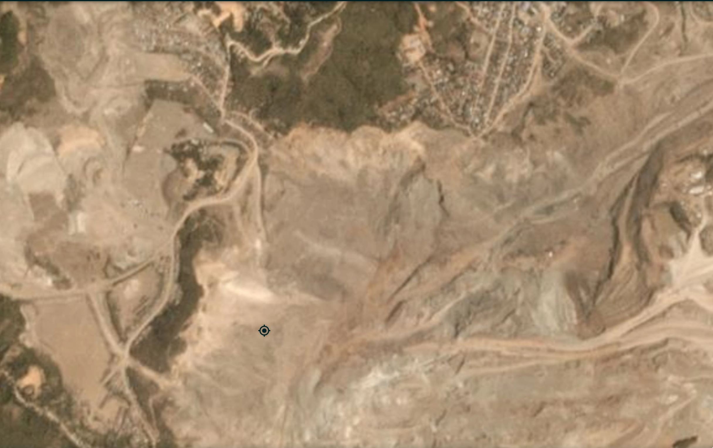
Satellite image of the 28 June 2020 Myanmar Jade mine landslide. Image copyright Planet Labs, used with permission.
.
The extraordinary level of environmental degradation caused by the jade mining activity in the Hpakant area is clear. Note that this does not appear to be well organised mining – look how close the houses are to the edge of the mine workings for example.
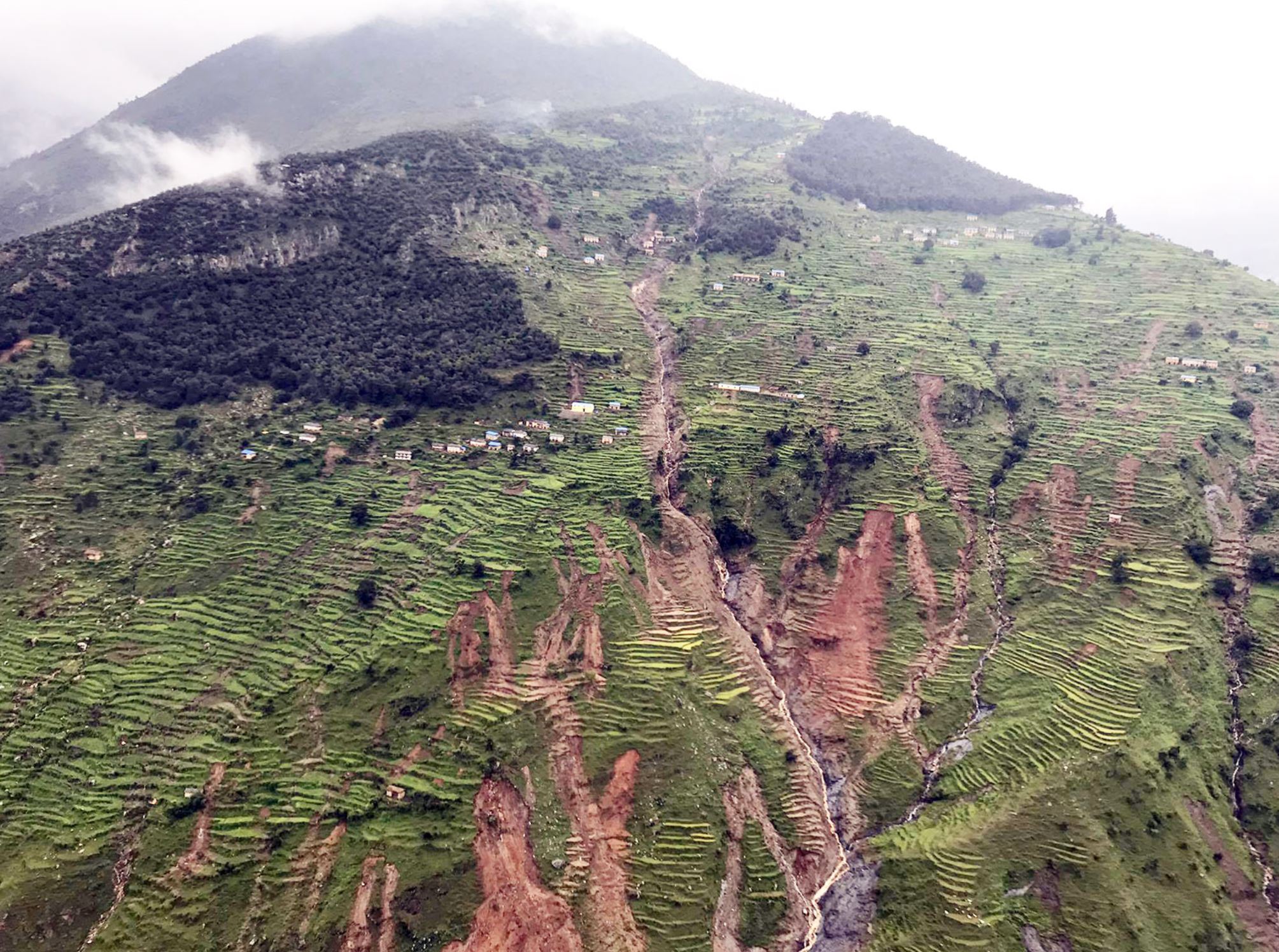
This an image after the landslide, captured on 10 July 2020:-
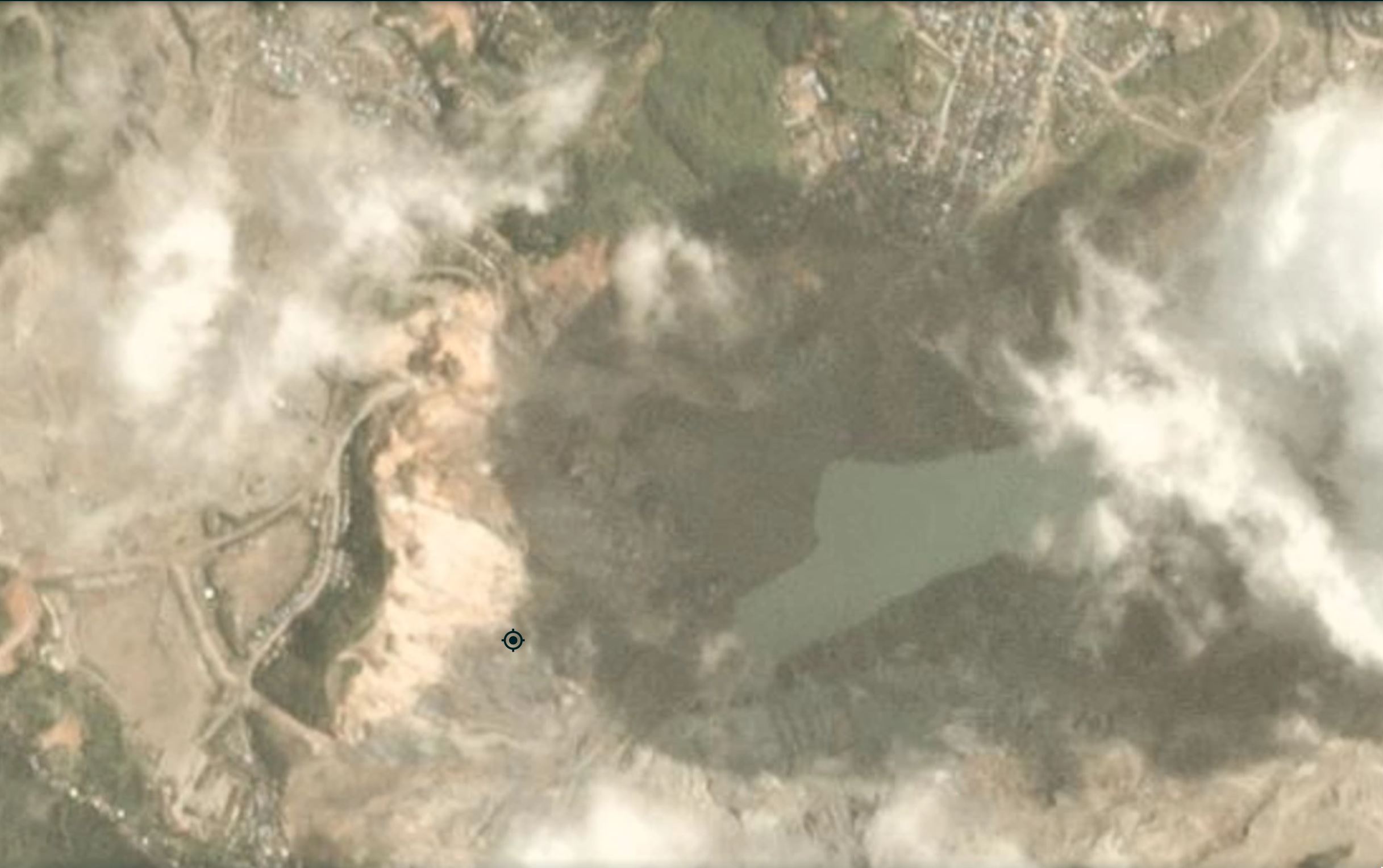
Satellite image of the aftermath of the 28 June 2020 Myanmar Jade mine landslide. Image copyright Planet Labs, used with permission.
.
The slope failure is just to the north of the position marker in the image, travelling roughly towards the east into the lake. It is not a huge failure – about 400 m x 400 m. The problem of course was the number of people on the slope at the time, and the displacement waves in the flooded pit bottom. Although the site is in shadow, the landslide is clear.
The image below is from Google Earth, from December 2018, showing the mining operations at the site:-
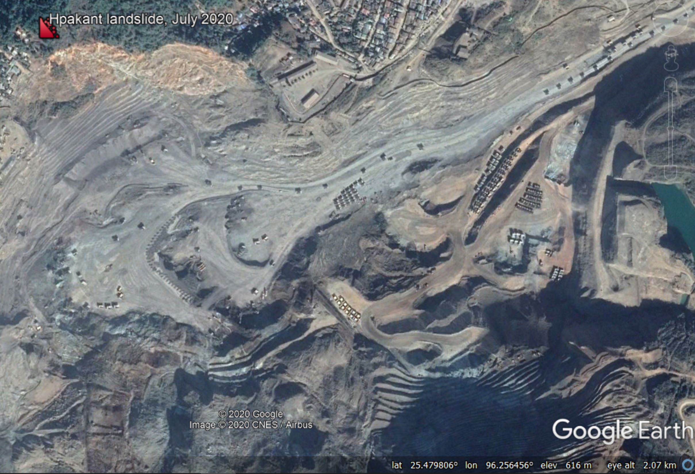
Google Earth image of the location of the 28 June 2020 Myanmar Jade mine landslide.
.
The image above shows the extremely large-scale of the mining operation at this site.
.
Quickslide 1: More fatal landslides in Nepal
This morning a further fatal landslide occurred in Nepal, with a family of three being killed in Machhapuchhre Rural Municipality in Kaski. Meanwhile, up to five people have been killed by a landslide at Pulpingkatti in the Bhotekoshi rural municipality in Sindhupalchowk.
.
Quickslide 2: Old Fort Road reopens
The landslide at Old Fort in Canada has now stabilised sufficiently for the road to reopen.
.
Reference
Planet Team (2020). Planet Application Program Interface: In Space for Life on Earth. San Francisco, CA. https://www.planet.com/
15 July 2020
Cromwell: helicopter sluicing to manage a landslide
Cromwell: helicopter sluicing to manage a landslide
An interesting landslide problem, and an unusual management approach, are under way at Cromwell on the South Island of New Zealand. The problem is a large rock slope failure that has developed at a critical road junction, between State Highway 8 and State Highway 8B, at Deadman’s Point Bridge. The image below, distributed by NZTA, shows the development of this slope failure and the obvious hazard to the road:-
The landslide at Cromwell in New Zealand. Image provided by NZTA.
.
This appears to be a wedge failure with substantial displacement in the rear scarp. The landslide is actively deforming. Clearly there is a high chance of a collapse event. To manage the hazard the road is closed at night.
In the aftermath of the Kaikoura earthquake, the transportation authorities had some success in using helicopter sluicing to manage slopes. This technique uses 1000 litre underslung buckets to deliver water onto the slope. This video, posted to Youtube, shows this operation underway at Cromwell:-
.
The Otago Daily Times has a report on the helicopter sluicing operation at Cromwell:-
NZ Transport Agency (NZTA) said this morning that sluicing work, involving helicopters with monsoon buckets dropping water on the slip, would continue and traffic would be stopped for up to 30 minutes at a time.
“This sluicing work will continue for the next few days at least until we are sure the hillside is again stable.”
NZTA maintenance contract manager Mark Stewart said after dropping 150,000 litres of water to control and flush the landslip yesterday, helicopters and crew got to work again about 9.30am this morning.
I haven’t seen this approach used much outside of New Zealand – it is certainly an interesting way to manage a slope.
The Cromwell Gorge is one of the most famous landslide sites globally. Detailed monitoring of slope behaviour in the large creep landslides continues.
Thanks to John Davies and Scott Johnson for highlighting this one to me. Much appreciated.
.
Quickslide 1: Cape Kidnappers risk assessment
Also in New Zealand, the Department of Conservation (DOC) has released the Quantitative Risk Assessments of the Cape Kidnappers site following the landslides there, which injured two people. The documents are a very interesting exemplar of how to undertake this type of work. Scoop has published some expert analyses of this work.
.
Quickslide 2: Mudslides and landslides in Indonesia
Heavy rainfall in North Luwu district of South Sulawesi province in Indonesia has killed 16 people and left 23 missing. Whilst the reports blame flash floods and landslides, the images appear to show the aftermath of mudslides. Information is a little sketchy at this point.
14 July 2020
Deadly monsoon-induced landslides in Nepal in the last few days
Deadly monsoon-induced landslides in Nepal in the last few days
Over the last few days intense monsoon rainfall in Nepal has triggered a wave of landslides that have caused extensive loss of life and damage. Worst affected appears to be the district of Myagdi in the central part of Nepal, one of the former Hill Districts of alpine height mountains. There, 27 people are known to have died and a further four are reported to be missing.
The most significant landslide appears to have occurred in Dhaulagiri Rural Municipality, where 18 people were killed, whilst eight people died in Malika Rural Municipality and one person was killed Raghuganga Rural Municipality.
Meanwhile, on Sunday another landslide struck Besinda, in Sankhuwasabha District at about 1 a.m. Eleven people are reported to have been killed, whilst four were rescued with injuries.
There is less clarity about a landslide that occurred on Sindhupalchowk District, which has suffered repeated landslide events since the 2015 earthquake. Three fatalities have been confirmed, but up to 20 people are reported to be missing.
In Jajarkot District, landslides in Borekot Gaunpalika-4 and elsewhere are reported to have killed ten people, whilst in Kaski there are reports of landslides at Sarangkot (five fatalities), Hemja (one fatality) and Paitedanda (one fatality).
Yesterday, a series of landslides in Tanahun District is reported to have killed another ten people and to have left two more missing.
On Twitter, @basanta58_raj has been posting and retweeting images of some of the landslides. This image shows the landslide at Barekot Gaonpalika-4 in Jajarkot, which I note above:-
The landslide at Barekot Gaonpalika-4 in Jajarkot, which is reported to have killed several people. Image from nayapatrikadaily.
.
This is a fascinating image showing both channelised debris flows and open hillslope failures. Meanwhile, this image from Ghartigaun, also in Jajarkot, appears to show incising flows that have initiated on a road high on this hillside:-
A channelised flow at Ghartigaun in Jajarkot in Nepal. Image via the Kathmandu Post.
.
Interestingly, there is increasing recognition in Nepal that a part of the problem is unconstrained and unregulated road construction. The Kathmandu Post has a good article highlighting this issue:-
However, disaster management experts say many of the deadly landslides were triggered by haphazard road construction that disturbed the slopes and natural drainage, while in the plains floods have been made worse by poorly designed roads, urbanisation of floodplains, deforestation and sand extraction in the Chure, as well as embankment building across the border in India.
.
Quickslide 1: Further landslide fatalities in Japan
Two people are thought to have been killed in a landslide at Higashihiroshima in Hiroshima Prefecture in Japan this morning.
.
Quickslide 2: Eight more landslide fatalities in India
The monsoon in India continues to trigger landslides that are causing substantial levels of loss. On Friday a series of landslides were triggered by heavy rainfall, killing eight people in Arunachal Pradesh.
9 July 2020
Shimen County, Hunan Province: a 3 million cubic metre rainfall triggered landslide
Shimen County, Hunan Province: a 3 million cubic metre rainfall triggered landslide
Heavy rainfall continues to fall across a swathe of Southern China, causing landslides and floods. This morning the national observatory has issued orange rainfall warnings for Jiangxi, Fujian, Zhejiang, Hunan and Guizhou, forecasting up to 280 mm of rainfall, with peak intensities of over 70 mm per hour. This is landslide-inducing levels of precipitation.
In Shimen County in Hunan Province the rainfall has triggered a very large landslide that has destroyed five houses. The landslide was caught on video, uploaded to Youtube. It is something of a medley of segments, but nonetheless captures failures from the rear scarp and the flow behaviour of the main mass.
.
There is a longer and more detailed version of this video on Youtube too. You will need to forgive the loud and unnecessary music, but it captures the movement of the main body of the slide well:
.
I have struggled to find a decent image of the landslide – this is the best that I have managed so far, from the start of the video (and hence the play arrow):-
The landslide at Shimen County in China. Still from a Youtube video.
.
Quickslide 1: A fatal landslide in Hubei province
Meanwhile, a landslide buried nine people yesterday in Yuanshan Village of Dahe Township, Huangmei County in Hubei province, again triggered by heavy rainfall. Xinhua reports that one of the victims has been recovered alive, whilst four remain buried.
.
Quickslide 2: The aftermath of the Myanmar jade mine landslide
Interestingly, there are news reports that the Myanmar Government is taking action to identify those responsible for the jade mine landslide in Myanmar, which killed over 160 people. The Khmer Times reports that two high ranking military officers, the Kachin Security and Border Affairs Minister Colonel Nay Lin Tun and an unnamed officer, have been dismissed. ECNS reports that a formal investigation of the landslide is under way.
7 July 2020
Erzincan: a very interesting mudflow in Üzümlü, eastern Turkey
Erzincan: a very interesting mudflow in Üzümlü, eastern Turkey
On 2 July 2020 a large and interesting mudflow occurred at Günebakan in the Erzincan area of eastern Turkey. The Turkish news site AA has an image of the aftermath of the landslide:-
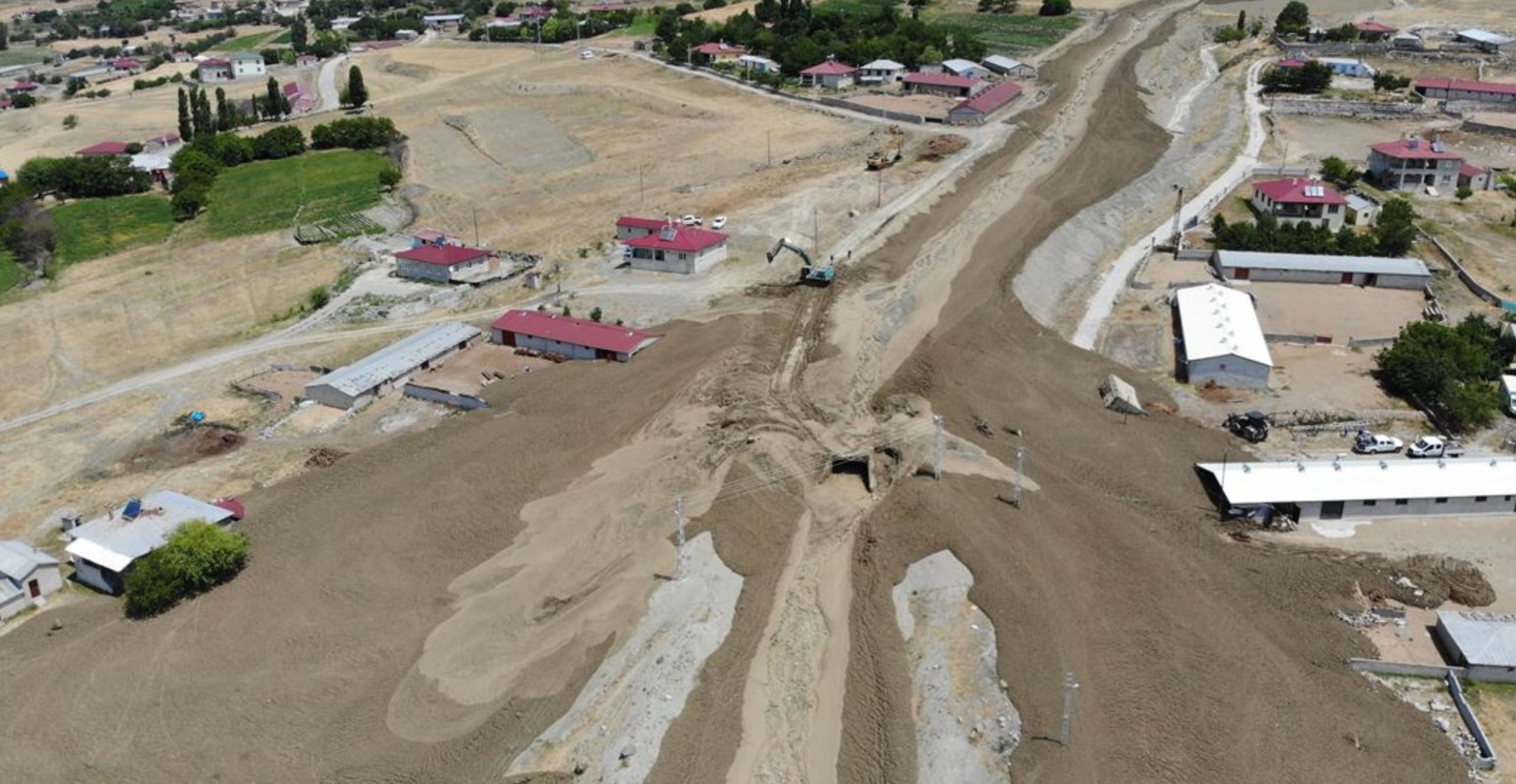
The aftermath of the mudflow at Günebakan in the Erzincan area of eastern Turkey in July 2020. Image via AA.
.
The landslide reportedly destroyed two houses and a number of stables, as well as killing some livestock. Fortunately no-one was killed.
The most interesting aspect of this landslide is that the latter phases of it were captures on a video that has been uploaded to Youtube by the Turkish news site Erzincan Haber :-
.
This video gets really interesting at about 26 seconds, when a small flow is captured travelling down the channel. At about 40 seconds it becomes fascinating as a much larger flow enters the system and propagates through the mud. The video captures really well the complex flow properties of these materials – initially the wave travels over the top of the existing deposit, but later on it becomes a waves that travels through the deposit. It’s very interesting behaviour that will provide insight for the landslide modelling community.
Thanks to Tolga Görüm for highlighting this one to me.
.
Quickslide 1: Lidar data of the Old Fort landslide
An excellent presentation of the new Lidar data from the Old Fort landslide has been posted online by the British Columbia Ministry of Transportation and Infrastructure. Thanks to Susan DeSandoli, who is kindly keeping me updated about this interesting landslide.
.
Quickslide 2: The rising toll from the heavy rains in Japan
The ongoing spell of the exceptional rainfall in Japan continues to generate extensive landslides and widespread flooding. Reuters reports that 44 people have now been killed and a further ten people are missing. The rainfall is steadily moving eastwards and is likely to last until at least Wednesday.
6 July 2020
Ashikita: a large landslide in the Kumamoto region of Japan
Ashikita: a large landslide in the Kumamoto region of Japan
Japan has once again suffered from exceptional rainfall in recent days, with the Kumamoto region of the island of Kyushu bearing the brunt. Landslides and flooding have occurred across a wide area. Further rainfall was forecast for Sunday evening. There is a good Wikipedia providing some details about this rainfall event. It reports peak rainfall intensities of about 100 mm per hour.
At Ashikita in Kumamoto Prefecture a large landslide occurred on a steep, forested mountain slope. Teller report has a good overview image of the landslide:-
The landslide at Ashikita in Kumamoto, Japan. Image from Teller Report, taken from a video filmed by the NHK helicopter.
.
Whilst there is a good drone video of the landslide on Youtube, posted by Ruptly:
.
This landslide reportedly occurred at 11:40 on 4 July 2020. When large landslides occur there is often a default view that human modification of the landscape, especially the removal of trees, is the cause (and often this is the case). This landslide appears to demonstrate that, as all landslide researchers know, failures are a natural process that can occur on undisturbed forested slopes.
.
Quickslide 1: An update on the Myanmar jade mine landslide
Loss of life from the landslide at a jade mine in Kachin State has reached 174 people, with a further 54 people reported to have been injured. An investigation of the landslide is apparently underway. Interestingly, the State Counsellor (equivalent to Prime Minister) Aung San Suu Kyi has blamed the disaster on joblessness, which forces people to scavenge for jade on the soil tips.
.
Quickslide 2: a dramatic rockslide in Idaho
A large and dramatic rockslide occurred on 3 July on US route 95 at Sheep Creek near to Riggins in Idaho. Yahoo News has a video of the incident. The road remains closed, and there is concern about further potential instability on the rockslope as a large crack has developed.
3 July 2020
The Dawn of Hope peat slide: understanding the source area
The Dawn of Hope peat slide: understanding the source area
My tweet yesterday linking to the remarkable video on Youtube by John Flynn that shows the full extent of the Dawn of Hope peat slide attracted a great deal of attention. One of the aspects of landslides that I enjoy the most is that, 30 years into my professional career, I still find slides that cause surprise. This is one, without doubt.
.
The video provides a source to toe record of the landslide, but of course it is the source area that has generated the most interest. I can only speculate on what is going on here – others will investigate it properly, and I will post their findings when published if possible. On Twitter some suggested that this might be a lateral spread that transitioned into a flow slide. I would speculate that this is unlikely. This image shows the lower part of the source area, and the transition zone into the channelised flow:-
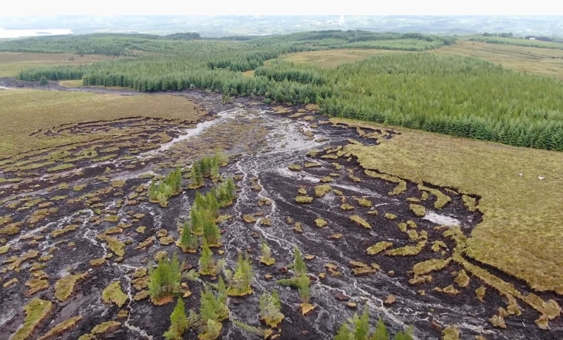
The lower part of the source area of the Dawn of Hope peat slide. Still from a Youtube video posted by John Flynn.
.
I would hypothesise that the slide initiated here as a bog burst and then retrogressed to create the extraordinary landform seen in the upper reaches of the source area:-
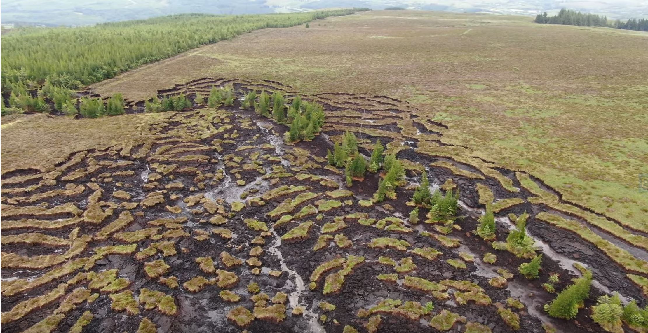
The upper part of the source area of the Dawn of Hope peat slide. Still from a Youtube video posted by John Flynn.
.
These are extensional landforms, which have generated because there was space vacated by the initial bog burst. The line of trees, mostly intact and upright, following the drainage line, is remarkable. It shows that the failure has propagated up the channel, and that in the channel itself mobility is quite high. The peat adjacent to the channel has failed, but with much lower mobility.
To understand landslides in peat there are a few important aspects to consider:-
- Peat is a predominantly organic material, with some clay and silt and a very large amount of pore space. This means that it has an unusually low density compared with other geomaterials. A typical density for peat is about 400 kg per cubic metre – less than half of that of water – so rafts of peat can literally float.
- The peat itself has low compressive strength, but is quite strong in tension. This is because the body of the peat consists of organic fibres. This may be the reason that the blocks have remained intact.
- Failure in peat slides very often occurs at the boundary between the peat and the underlying substrate. I think there is some evidence that this is the case here.
So, my hypothesis would be that the extreme rainfall, perhaps aided by piping in the peat, led to very high pore water levels in lower part of the topographic depression shown in the first image. This failed to generate a bog burst, and a large amount of degraded organic material vacated the depression and entered the channel. It clearly entrained considerable amount of material from within the channel, and of course the structure of the peat was rapidly lost in the turbulent flow, creating a slurry with high mobility.
Back in the source area, the now vacated depression allowed failure of the adjacent blocks. Failure propagated upwards through the depression, aided by the high pore water pressures. But of course these materials are highly permeable, so failure also induced rapid drainage, especially away from the channels. Thus, the pore water pressures at the base of the blocks quite rapidly declined, leaving the peat rafts stranded.
The video also shows the areas of inundation (there is more than one) downstream:-
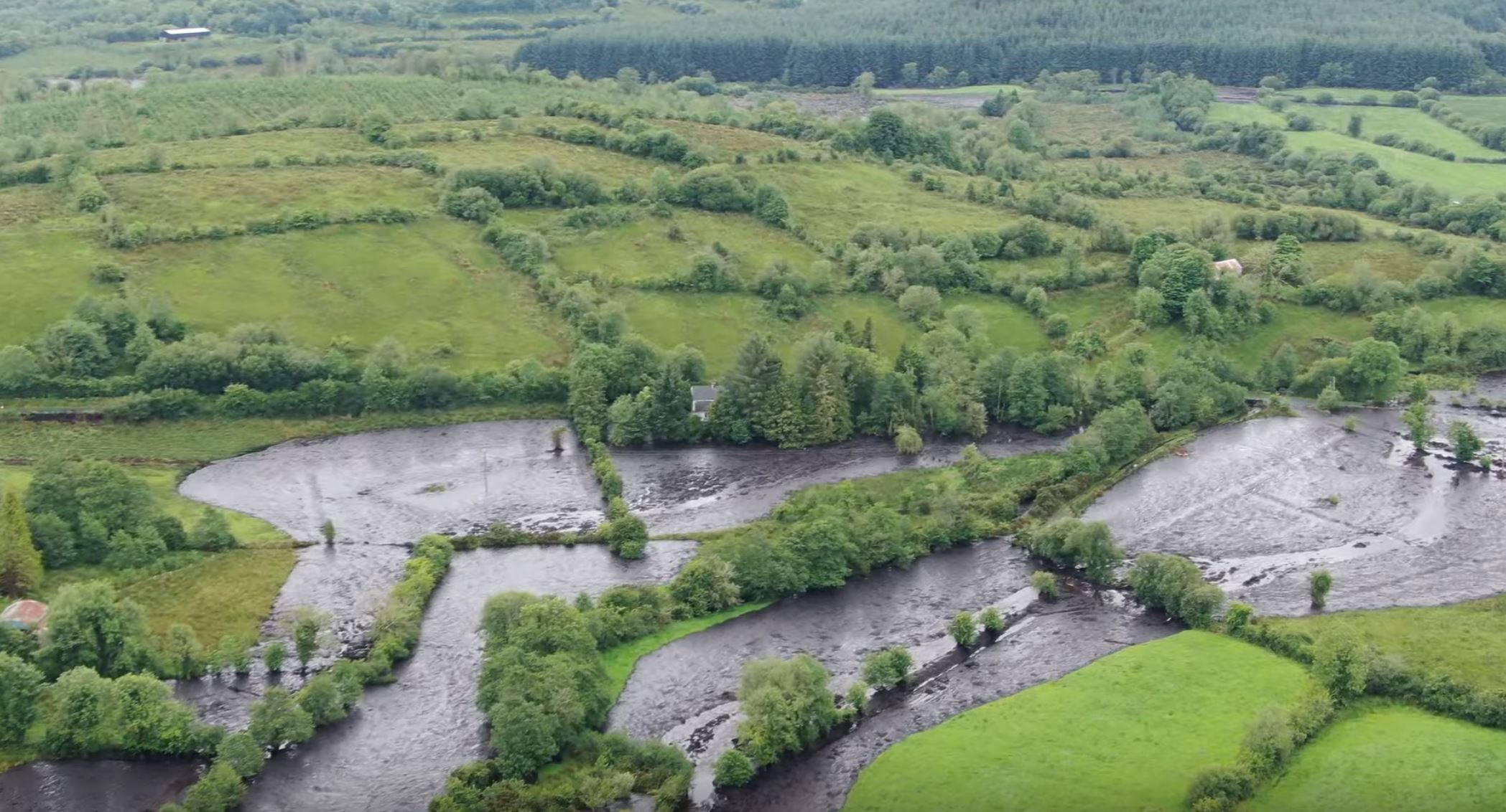
One of the inundated areas from the Dawn of Hope peat slide. Still from a Youtube video posted by John Flynn.
.
The level of damage here is undoubtedly high.
I welcome comments about this landslide, and my interpretation of it. I’m aware that the comment function is not working correctly at the moment, so I will try to add the key comments to the main text below when I get a chance.
.
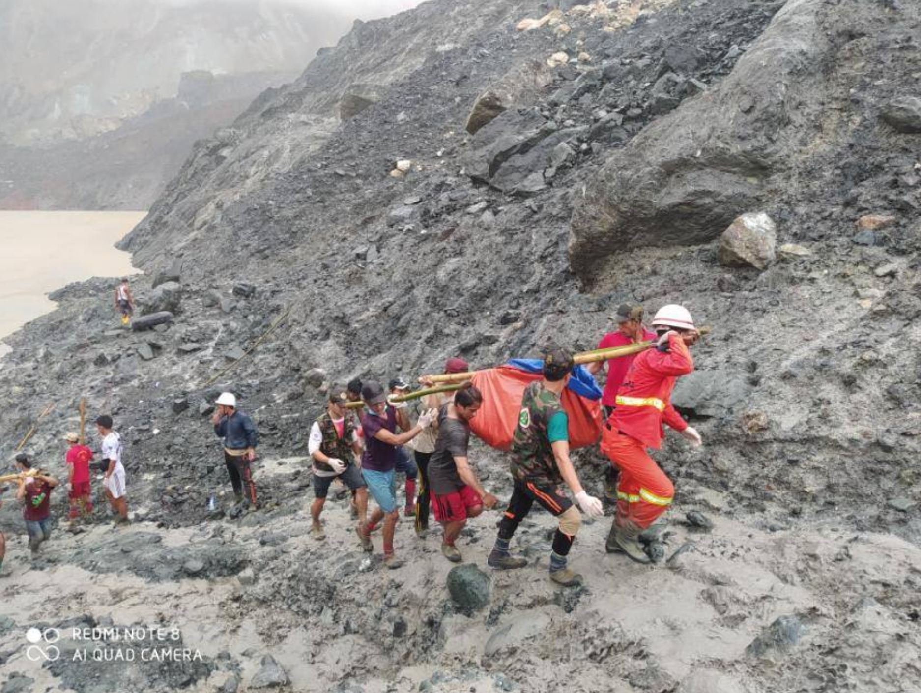
Quickslide 1: The Sate Mu jade mine landslide
Loss of life from the Sate Mu Jade Mine landslide is now at least 166 people, making it the worst landslide of 2020 to date. Heavy rainfall is hampering the rescue, so the number remaining missing is unclear. A much better version of the video of the failure has now been tweeted. Tragically, the video appears to show a very large number of people on the slope at the time of failure:
Dramatic video shows the moment a landslide overtook a jade mine in Myanmar, killing more than 150 people in the incident according to officials. https://t.co/6e229rlIcr pic.twitter.com/3K1RlNAh2M
— ABC News (@ABC) July 2, 2020
.
Quickslide 2: NASA imagery of the Achoma landslide
NASA has now posted before and after satellite imagery of the Achoma landslide in Peru. It is useful, but is less impressive than the Planet Labs image that I posted a few days ago.
2 July 2020
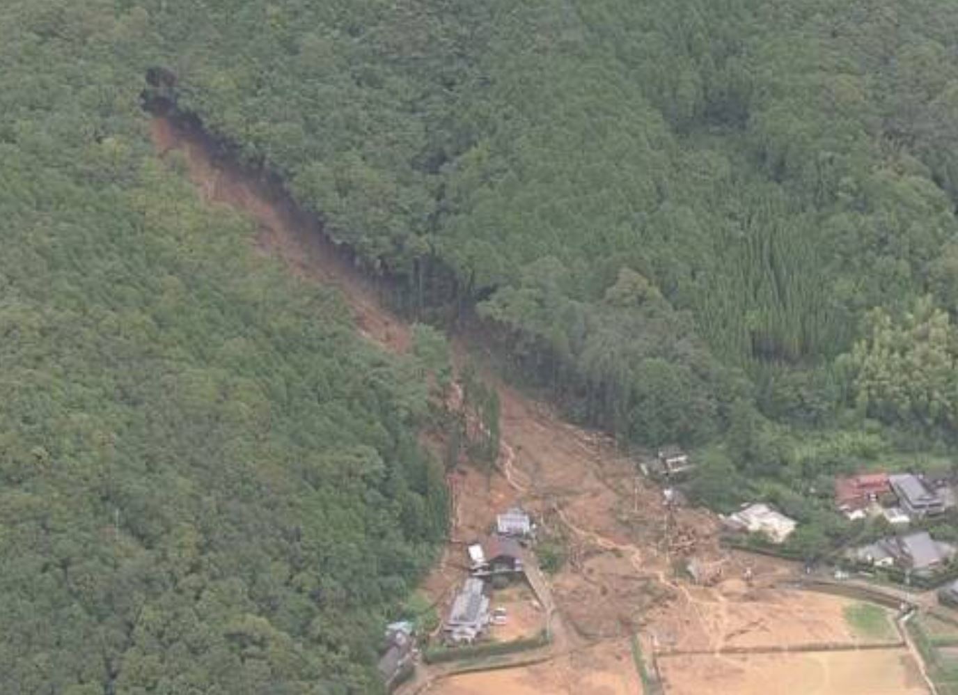
Sate Mu village: another dreadful jade mining landslide in Myanmar
Sate Mu village: another dreadful jade mining landslide in Myanmar
Today (2 July 2020) another dreadful landslide has occurred in the Hpakant jade mining area of Kachin state in Myanmar. Loyal readers will know that this is the most frequent location for major landslide tragedies anywhere in the world.
The landslide this morning occurred close to Sate Mu village in Hpakant. The latest figures in terms of lives lost are given on the Facebook Page of the Myanmar Fire Service, who report 113 victims recovered so far, with search and rescue operations continuing. There appear to be fears that there may be many more people buried.
Earlier reports suggest that this was a failure of a tall slope (the report suggests 304 metres, but this seems surprising) on to people scavenging for jade. In general people who undertake this type of scavenging work on the spoil piles from the mining operations, so this may well be a mine waste failure once again. The landslide appears to be associated with heavy monsoon rainfall.
Huge care is needed in the interpretation of images in newspapers from these types of events as they frequently recycle pictures from earlier events. However, the this image of the Sate Mu landslide from the Myanmar Fire Service is probably genuine:-
The aftermath of the Sate Mu landslide in Myanmar. Image from the Facebook page of the Myanmar Fire Service.
.
This would seem to indicate that this video, which was posted to Twitter, might also be genuine. I don’t think I have seen this video before, and in basic configuration it appears to fit the situation. The jury is still out though:-
https://twitter.com/COVIDGazette/status/1278580728431693825?s=20
.
Hopefully more will emerge in the next day or so, but the Sate Mu landslide might well be the most deadly landslide in the jade mining areas of Myanmar to date. In September 2018 I summarised the known landslide fatalities in Hpakant to that point.
.
Quickslide 1: At least six people killed in landslides in Brazil
A rapidly intensifying cyclone caused heavy rainfall in Santa Catarina in southern Brazil. Some news reports indicate that six of the fatalities were caused by landslides.
.
Quickslide 2: Further landslide losses in Assam
Heavy rainfall in Assam has caused a further round of landslides and flooding in northern India.
.
1 July 2020
Dawn of Hope: a major peat landslide in County Leitrim, Republic of Ireland
Dawn of Hope: a major peat landslide in County Leitrim, Republic of Ireland
Exceptional rainfall on Sunday 28 June 2020 triggered a major landslide at Dawn of Hope in Count Leitrim in the Republic of Ireland. This is an unusual landslide – the failure of a peat bog. Peat bog landslides are remarkable for their mobility and for the damage that they can cause.
The Irish Farmers Journal has a report about this event, which has seen the failure of a large area of peat bog and deposition on a large area too. The location is 54.201, -8.086 if you wish to take a look.
The best understanding of this remarkable failure can be gained from a series of three drone videos posted to Youtube by Garadice 2000. The best overview can be gained from the second in the series, which at the end appears to provide a view of the source area of the landslide:-
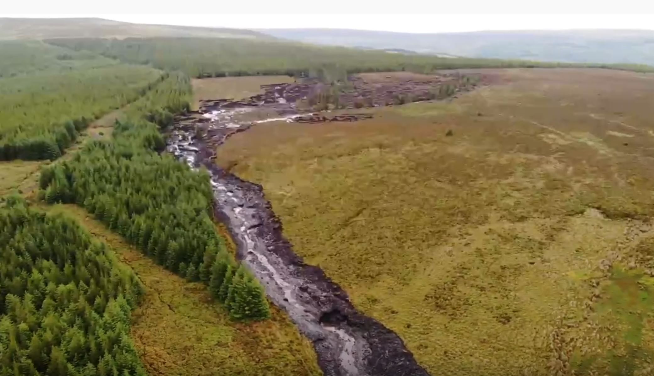
The source area of the Dawn of Hope landslide in County Leitrim. Still from a video posted to Youtube.
.
.
Meanwhile the video in the following tweet provides a really good impression of the long track of the landslide:-
Drone footage shows the cumulative effects of wide scale plantation @coilltenews forestry at the Dawn of Hope Bridge bog slide in Drumkeeran No EIA on any plantation in #Leitrim to date & almost 20% of the total county planted. It is having a MASSIVE environmental impact pic.twitter.com/9aC0yIsILJ
— Edwina Guckian (@EdwinaGuckian) June 30, 2020
.
The landslide has caused extensive damage downstream. This image, from the Irish Farmers Journal, shows the inundated area:-
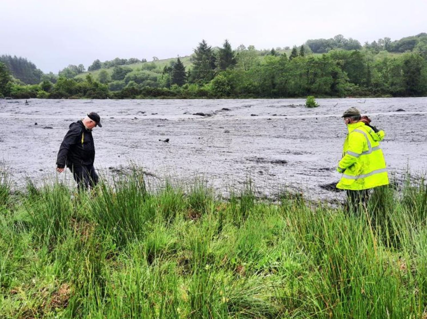
The area inundated by the Dawn of Hope landslide in County Leitrim. Image by John O’Hanlon IFA, via the Irish Farmers Journal.
.
Quickslide 1: The Old Fort landslide has slowed
The Old Fort landslide in Canada has slowed considerably, with a reported movement rate of about 10 cm per hour. Unfortunately, heavy rainfall is forecast for the next few days.
.
Quickslide 2: More heavy rainfall in China
China has once again issued a rainfall warning, this time for the regions of Sichuan, Chongqing, Guizhou, Yunnan, Guangxi, Fujian and Zhejiang. Over 12 million people have been affected so far.
30 June 2020
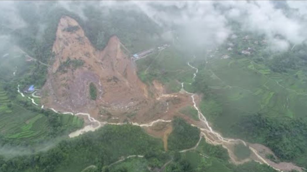
The 18 June 2020 Achoma landslide in Peru
The 18 June 2020 Achoma Landslide in Peru
On 18 June 2020 the very large Achoma Landslide occurred in valley of the Rio Colca in Peru. Many thanks to Gael Araujo of the Geological Service of Peru for highlighting this one to me, and to Robert Simmon of Planet Labs who independently identified it from satellite imagery. As far as I am aware, this landslide has not been reported in the English language media, but it is a very large, valley-blocking failure. La Republica has some drone imagery that gives a good impression of the scale of the landslide:-
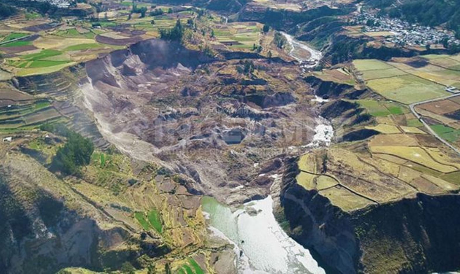
Drone imagery of the the 18 June 2020 Achoma landslide in Peru. Image by Ingemmet via La Republica.
.
As the image shows, the landslide has blocked the Rio Colca, allowing a lake to form. As of yesterday, the volume of the lake was about 2 million cubic metres. A state of emergency has been declared for the area, lasting 60 days, whilst efforts are being undertaken to drain the lake. The video below, collected by Ingemmet, should provide a good impression of the scale of this landslide:-
https://twitter.com/IngemmetPeru/status/1275213759716483072?s=20
.
As noted above, Planet Labs has collected an excellent satellite image of this landslide:-
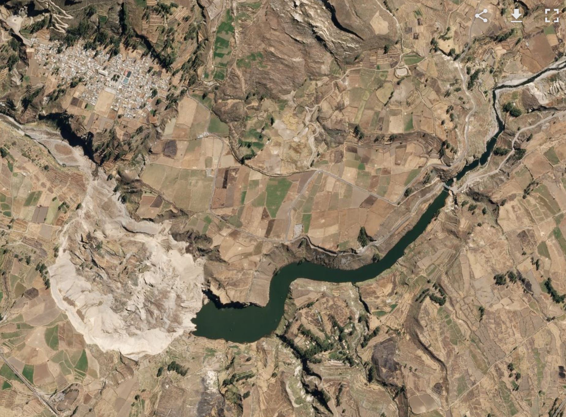
.
This image clearly captures the scale of both the landslide (which covers an area of about 40 hectares) and the developing barrier lake.
.
On reflection 1: A rare peat bog landslide in Eire
It appears that a large peat bog landslide occurred in North Leitrim in Eire over the weekend, triggered by heavy rainfall. Does anyone have any more information?
.
On reflection 2: The Tylerstown landslide – an update
Work has started to clear the 60,000 tonnes of landslide debris from the Tylorstown landslide in Wales.
 Dave Petley is the Vice-Chancellor of the University of Hull in the United Kingdom. His blog provides commentary and analysis of landslide events occurring worldwide, including the landslides themselves, latest research, and conferences and meetings.
Recent Comments