
1 November 2022
Planet Labs images of the Kusiong landslides in the Philippines
Posted by Dave Petley
Planet Labs images of the Kusiong landslides in the Philippines
Inquirer.net has eyewitness accounts of the devastating 27 October 2022 Kusiong landslides in the Philippines, triggered by Severe Tropical Storm Nalgae (Paeng).
“…an avalanche of huge rocks and boulders with mud cascaded quickly toward the relocation site where the Teduray indigenous peoples had been living since 2021. “We heard thundering sounds and people yelling for help as mud and rocks entered our house,” recalled Mercy, 55, a survivor, in an interview on Sunday afternoon. “I could not remember what happened next” or how she and her children survived the rock avalanche, said Mercy, who, along with her children, were awakened from their deep sleep by the thunderous sound...Many of the survivors suffered from leg and foot injuries since the floods and rocks literally were running after them as they fled, said the village chief.
Meanwhile, Planet Labs has captured an image of the affected area, which powerfully demonstrates what happened. This is a lower resolution (but still excellent) PlanetScope image, captured on 31 October 2022:-
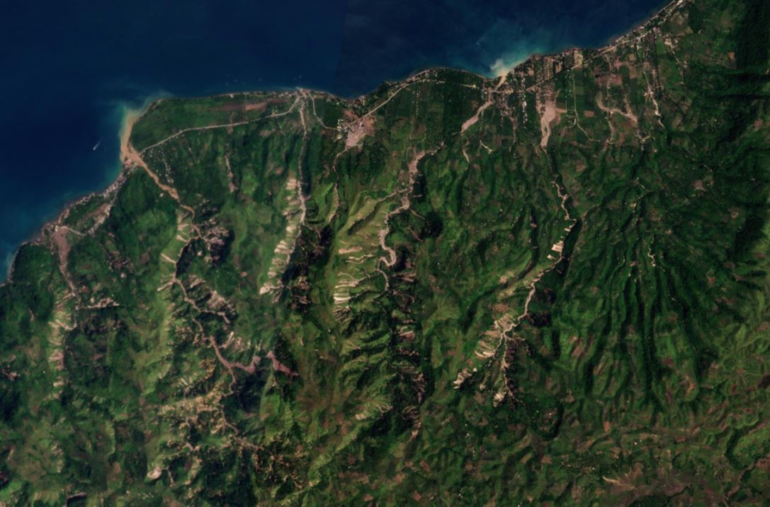
The aftermath of the Kusiong landslides. Planet Labs PlanetScope image, captured on 31 October 2022. Copyright Planet Labs, used with permission.
.
I have annotated this image below to highlight the main areas:-
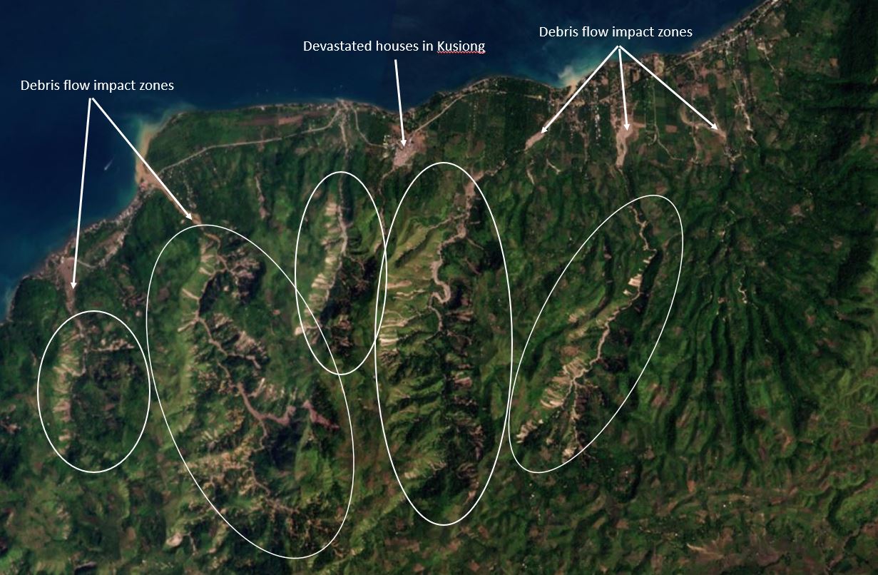
Annotated satellite image of the aftermath of the Kusiong landslides. Planet Labs PlanetScope image, captured on 31 October 2022. Copyright Planet Labs, used with permission.
.
I have highlighted in white the main areas of landslides across five catchments. In these zones the density of landslides is high. These appear primarily to be shallow landslides that have merged in the channels to become channelised debris flows, which have hit the communities.
The biggest single impact of the Kusiong landslides occurred in Datu Odin Sinsuat, which I believe is the site of the devastated houses that I have highlighted in the image. There are 31 confirmed fatalities at this location, with a further seven at the nearby Datu Blah Sinsuat. This is a Planet Labs image of the site of Datu Odin Sinsuat:-
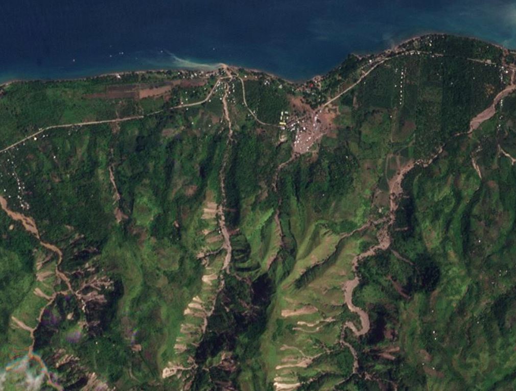
The aftermath of the Kusiong landslides in the area of Datu Blah Sinsuat. Planet Labs PlanetScope image, captured on 30 October 2022. Copyright Planet Labs, used with permission.
.
The catchment upstream of Datu Blah Sinsuat is comparatively small, and the occurrence of landslides is rather less than in adjacent catchments. To me this highlights two things – first, the disaster is primarily the result of the vulnerability of the community, and second the hazard itself might have been affected by the timing of the shallow landslides within the small catchment, perhaps generating a large pulse of debris as described by the eyewitnesses.
These types of landslides are usually caused by extremely intense rainfall (a cloudburst type event). It seems likely to me that this comparatively small part of Maguindanao del Norte province was probably hit by a pocket of exceptional rainfall within the main tropical storm.
Of course the Kusiong landslides need a proper scientific investigation, including mapping from imagery and fieldwork, and analysis of any available rainfall records.
.
Reference and acknowledgements
The images are from the wonderful people at Planet Labs.
Planet Team (2022). Planet Application Program Interface: In Space for Life on Earth. San Francisco, CA. https://www.planet.com/
 Dave Petley is the Vice-Chancellor of the University of Hull in the United Kingdom. His blog provides commentary and analysis of landslide events occurring worldwide, including the landslides themselves, latest research, and conferences and meetings.