
20 October 2022
Landslides from the 14 August 2021 M=7.2 earthquake in Haiti
Posted by Dave Petley
Landslides from the 14 August 2021 M=7.2 earthquake in Haiti
On 14 August 2021 an Mw=7.1 earthquake struck Nippes Department in Haiti. The earthquake, which was shallow (just 10 km), killed at least 2,248 people, with more than 12,200 injured, and at least 137,500 buildings were damaged or destroyed.
The landslide triggered many landslides. In an open access paper just published in the journal Natural Hazards and Earth System Sciences, Havenith et al. (2022) report the results of mapping and analysis of the landslide distribution. In total they identified 7,091 landslides, a much lower total than were mapped for the devastating January 2010 earthquake in Haiti. However, the mapping technique used here did not allow the smallest landslides to be detected. The surface area of the mapped landslides for the 2021 event is large (80 km²), indeed much larger than for the 2010 event. Thus, Havenith et al. (2022) have concluded that the total number of triggered landslides in the 2021 event was probably larger.
Some of the areas of landsliding are spectacular. This for example is a zone highlighted in the paper, located close to the trace of the fault:-
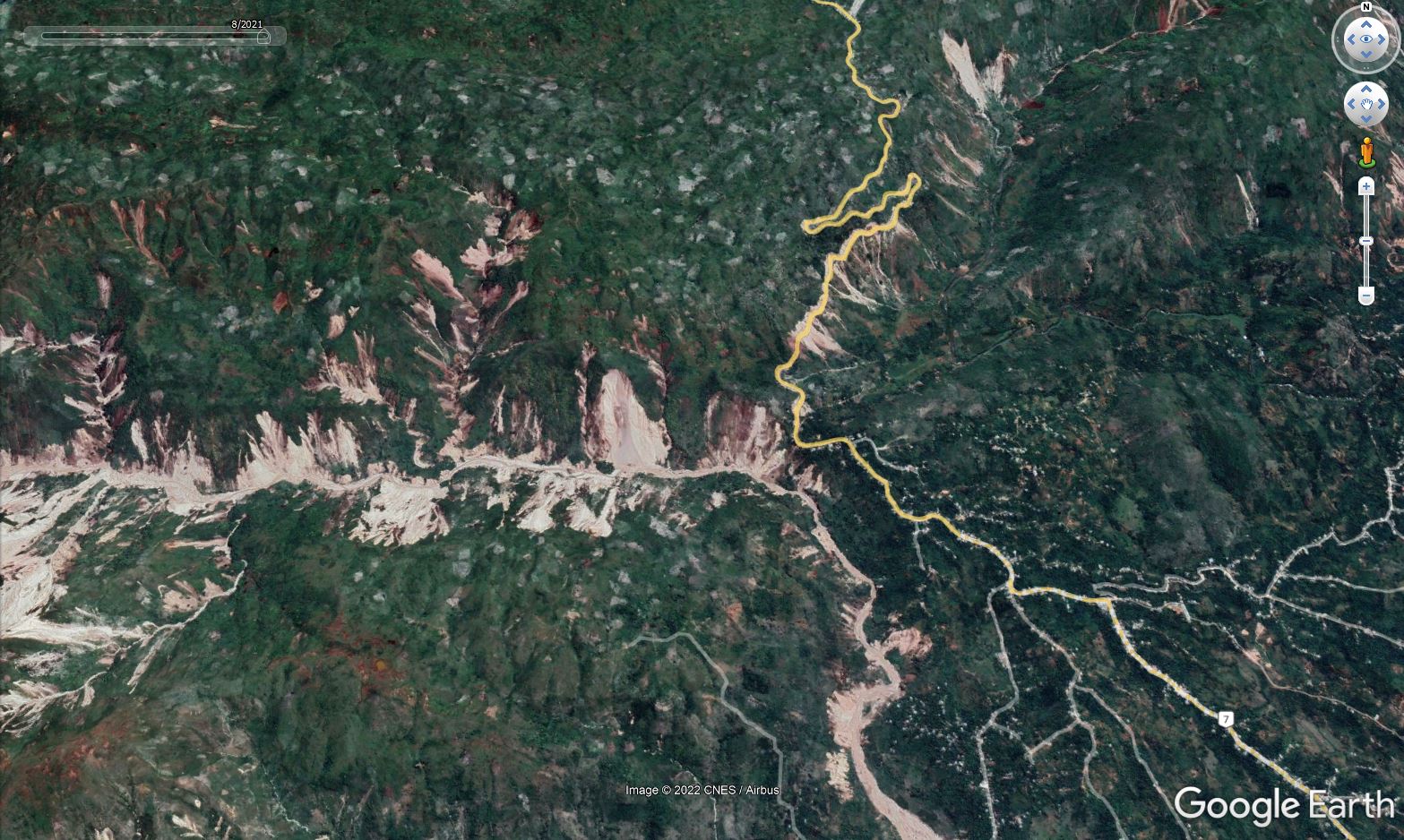
Google Earth image of the aftermath of the 14 August 2021 earthquake in Haiti. This image was collected on 23 August 2021.
.
Havenith et al. (2022) consider why the area of landsliding in the 2021 event was larger than was the case in 2010. The magnitude of the 2021 earthquake was a little higher, which may account for some of the effect, but they believe that other factors might be in play. For example, this area was affected by a M≈7.5 earthquake in 1770, which may have preconditioned the slopes for failure, although the authors recognise that this is hard to quantify. Additionally, the terrain in the western part of Haiti might be more susceptible to landslides (the authors are working on a further paper exploring this issue).
But perhaps most interestingly, Havenith et al. (2022) suggest that the area had been preconditioned for failure by Hurricane Matthew, which struck Haiti in October 2016. This major storm generated very high precipitation totals “precisely over the area that was later hit by the earthquake”. The area was hit by another tropical storm, Grace, a few days after the earthquake, which caused further landsliding, although the impact appears to have been quite limited.
The idea that the slopes has been preconditioned by previous events is very interesting. We explored this idea for earthquake induced landslides in New Zealand in a paper led by my former PhD student Rob Parker (Parker et al. 2015). The evidence is strengthening that major seismic and rainfall events leave a legacy in the hillslopes that subsequent events exploit magnifying impacts.
This of course has key implications for our understanding of the likely impacts of climate change. As the frequency of very intense rainfall increases, we will see not only more landslides being directly triggered but also more damage in the slopes that can be exploited by subsequent storms (or earthquakes).
Research of this type is in its infancy, but it is a very exciting area of investigation.
.
References
Havenith, H.-B., Guerrier, K., Schlögel, R., Braun, A., Ulysse, S., Mreyen, A.-S., Victor, K.-H., Saint-Fleur, N., Cauchie, L., Boisson, D., and Prépetit, C. 2022. Earthquake-induced landslides in Haiti: analysis of seismotectonic and possible climatic influences. Natural Hazards and Earth System Sciences, 22, 3361–3384, https://doi.org/10.5194/nhess-22-3361-2022.
Parker, R.N,., Hancox, G.T., Petley, D.N., Massey, C.I., Densmore, A.L., Rosser, N.J. 2015. Spatial distributions of earthquake-induced landslides and hillslope preconditioning in the northwest South Island, New Zealand. Earth Surface Dynamics, 3 (4), 501-525.
 Dave Petley is the Vice-Chancellor of the University of Hull in the United Kingdom. His blog provides commentary and analysis of landslide events occurring worldwide, including the landslides themselves, latest research, and conferences and meetings.