
6 September 2022
The Hongya Village landslide in Qinghai, China
Posted by Dave Petley
The Hongya Village landslide in Qinghai, China
On 1 September 2022 a very major landslide occurred at Hongya Village in Qinghai Province in China. I am surprised that this event has not attracted more attention – in scale it is certainty one of the most significant landslides of the year to date. The image below, the best I have found, provides an overview of this major failure:-
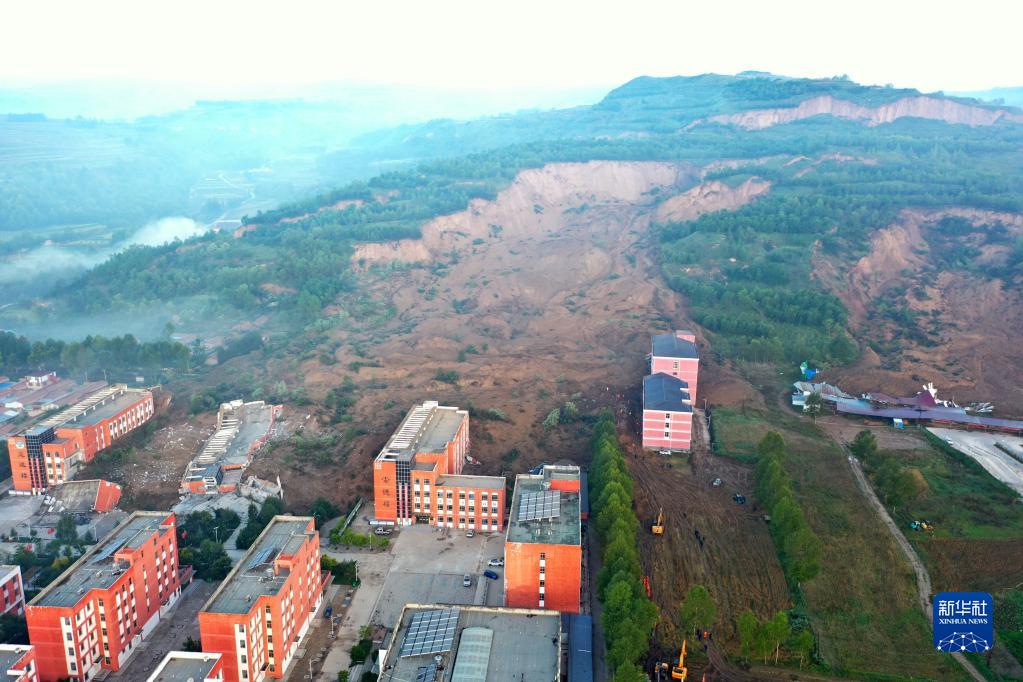
The aftermath of the 1 September 2022 landslide at Hongya Village in Qinghai. Image via news.cn, originally published by Xinghua.
.
The location of the landslide is 36.860, 101.933. On first inspection the failure appears to have occurred in a loess slope, common in this area, although there is low certainty on this. A report in stnn.cc estimates the volume of the landslide at 3.2 to 3.8 million cubic metres.
As the image above shows, the landslide caused the collapse of two large buildings. In the centre left, one large block has collapsed completely, whilst in the lower left a building has been rotated. The buildings are a part of the No. 3 Middle School in Huzhu County. Fortunately the school was closed at the time of the landslide, reportedly because of the pandemic. This landslide could have been had exceptionally high loss of life but for that piece of luck.
In total it is reported that seven people were killed in the failure. Four people were rescued.
The image below provides an overhead view of the landslide:-
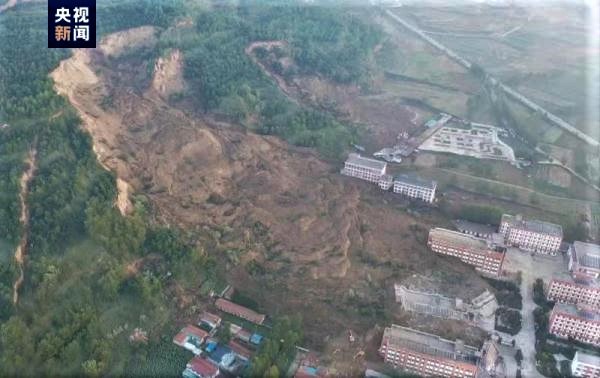
Vertical view of the 1 September 2022 landslide at Hongya Village in Qinghai. Image via GMW.cn.
.
Both images show that there was another large failure to the side of the main landslide at Hongya Village. Some structural damage is evident from this failure, although I can find no detail. But perhaps more significantly, there appears to be a very large, fresh scarp much higher up the slope, with perhaps a suggestion of some deformation downslope from this. Is there a much larger slope failure present here? I cannot find any evidence of this scarp on the archive Google Earth imagery of this site. If so then there will be some substantial future challenges at this site.
 Dave Petley is the Vice-Chancellor of the University of Hull in the United Kingdom. His blog provides commentary and analysis of landslide events occurring worldwide, including the landslides themselves, latest research, and conferences and meetings.
Lucky the two pink buildings on the right.You are right, the whole area looks that is seating on difficult soils. Thank you for sharing.
The first image is truly scary. My money is on an active “master slide”, and this pair in front have failed out of the roll-over zone along the toe. They should abandon this facility and relocate it if possible.