
15 July 2022
Landslides triggered by exceptional rainfall in Australia
Posted by Dave Petley
Landslides triggered by exceptional rainfall in Australia
The last few months have seen a series of exceptional rainfall events in the eastern part of Australia, triggering extensive flooding and landslides. In recent says this series of events has continued, with another major rainfall event causing extensive problems. Loyal reader Scott Johnson has kindly provided a series of updates to me as these events have developed.
The landslide with the largest long term impact occurred at Blackheath in New South Wales on Main Western Line, a major railway through the Blue Mountains. A set of images were posted to Facebook by Transport for NSW – this one shows the scale of the landslide:-
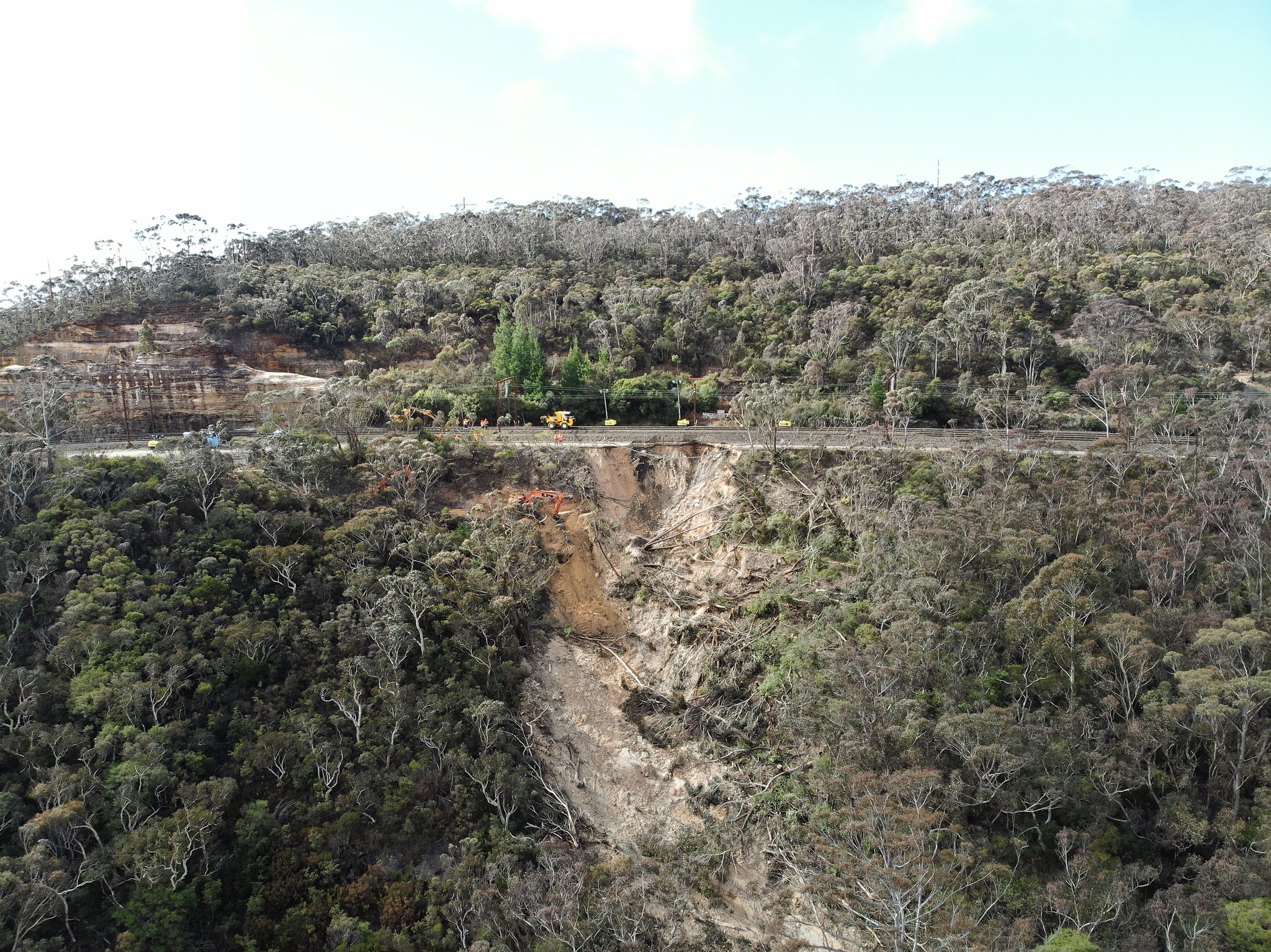
The landslide at Blackheath in New South Wales. Image posted to Facebook by Transport for NSW.
.
Clearly in global terms this landslide is not large, but it is undoubtedly serious. The nature of the terrain, and the remote location, means that mitigation is extremely challenging. Transport for NSW has posted a video update on the ongoing mitigation works. This still shows the scale of the excavations that have been necessary to reach a firm foundation, allowing a stable slope to be created to provide a secure track bed:-
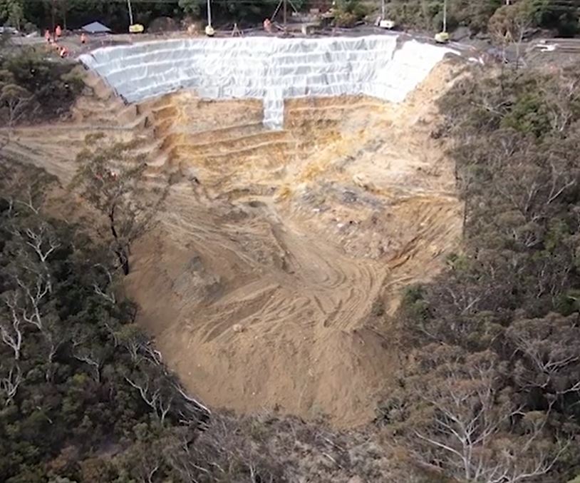
Ongoing mitigation of the landslide at Blackheath in New South Wales. Image from a video posted to Facebook by Transport for NSW.
.
The target date to get one line functioning is 24 July 2022, with a focus on night time freight traffic in the first instance. The line is a critical route for the transport of grain, coal, minerals and meat across the Blue Mountains to Sydney and the east coast area. Thus, the economic cost of this landslide is likely to be high.
Meanwhile, on the banks of the Hawkesbury River in NW Sydney, a rather different landslide problem has developed at Richmond Lowlands. ABC News has a good video report about this event, triggered by flooding on the river. This still from the video shows the scale of the problem:-
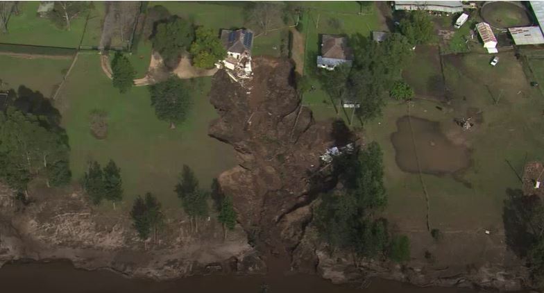
The landslide at Richmond Lowlands on the Hawkesbury River. Still from a video by ABC News.
.
The house is, I believe, located at -33.5667, 150.7624. The flooded area on the right side of the image presumably indicates that the ground was saturated whilst the river was in flood at the time of the failure. A flood warning bulletin released on Sunday 10 July indicates that the river level was falling at that time. The landslide is reported to have occurred at about 10 am on Monday 11 July, indicating perhaps that it was a drawdown failure. The form of the landslide indicates that it might have been a retrogressive event, initiated by collapse of the riverbank at the toe.
It is not immediately obvious to me why such a large failure has developed at this particular location. Failures have developed at other sites too.
 Dave Petley is the Vice-Chancellor of the University of Hull in the United Kingdom. His blog provides commentary and analysis of landslide events occurring worldwide, including the landslides themselves, latest research, and conferences and meetings.
The terrain is likely to be flood deposits and adjacent properties have flooded depressions – waterlogged soil from five months of La Nina rainfall would be enough ?
Much of the north west of greater Sydney (Nepean River) is behind the narrow Hawkesbury gorge, so very susceptible to 20m floods. Governor Macquarie in the 19th century wrote that anyone settling there below the known maximum flood height should not expect compensation…
Could there have been a ‘winter-burn’ seasonal stream that’s been back-filled ? Creating a hidden weakness, ready for gulley formation ??
Cousins lived near a gap in row of ‘semis’ where such had crossed. Later developer had snapped up the vacant plot, but new property was plagued by damp rooms and dank garden until glance at ‘Victorian’ map nailed cause. Much remedial ground-work, land-drains etc required…
Hi – love your blogpost on landslides. I work for the NSW National Parks & Wildlife Service in Australia – my role includes preparing risk management policies for protecting visitors to national parks, and managing risks to land adjoining national parks.
There have been several landslide and rockfall incidents in NSW national parks resulting in fatalities, including the landslide at the Thredbo ski resort in 1997. Recent heavy rainfall in eastern Australia has caused many landslides in national parks and major damage to nearby roads and railway lines (as you detailed in your recent post).
We manage landslides and rockfalls in national parks under under a published policy, which is guided by qualified geotechnical engineers:
https://www.environment.nsw.gov.au/topics/parks-reserves-and-protected-areas/park-policies/landslides-and-rockfalls
Regards
For the Blackheath case, is there any control of the drainage upslope of the road? Because to me the landslide seems related to the water draining from above so as the water is incising the surface, the lateral parts of the drainage way are collapsing.
For the Richmond Lowlands case, also the flood water coming from above created a gully that further triggered the collapse of the banks. there is a paper on this kind of gullies (floodplain gullies) in Australia.
I wrote the above comment because especially in the Blackheath case, I fear that the landslide could reactivate in future rainy periods if the upslope drainage brings water under the filling deposit. This is a feature of many landslides affecting roads in Romania, aka the wrong drainage: sure the material stays nice between rainfalls, but when water is inside the landsliding could appear.
I would say that this is the culprit. See my comments bellow.