
5 July 2022
The Tupul landslide: understanding the site
Posted by Dave Petley
The Tupul landslide: understanding the site
Recovery works continue at the site of the 30 June 2022 Tupul landslide in Manipur, India. News reports at the end of 4 July 2022 indicate that the bodies of 47 victims have now been recovered, with a further 14 people missing, two of whom are soldiers.
Meanwhile, my post yesterday has prompted the unearthing of some further videos of interest. Loyal reader Ryukai has highlighted a video collected immediately after the landslide that captures the start of water flow over the landslide dam:-
.
A third video captures small collapses occurring in the head scarp area:-
.
Inevitably, questions are now being asked about the degree to which this landslide should have been anticipated and could have been prevented. For example, the Times of India has an article that points out details from Geological Survey of India report about landslides in the Tupul area, completed in 2018-19:-
While it may take some time to pinpoint the exact cause of the Tupul incident, the GSI had found that out of 170 landslides that occurred between 2011 and 2017, “most have occurred in extensive slope cut during construction of road/railway line. Out of 170 recorded slides, only 30 slides were on natural slopes abd tthe rest were of anthropogenic origin…The GSI report said even “railweay is at risk” on NH37, Imphal-Jiribun highway, because of “cutting of slope for railway line and increase in pore water pressure reducing the conhesive strength of the overburden materials”.
Whilst one might quibble at some of the detail here, the overall message is absolutely clear. This is landslide-prone territory, and slope cutting is exacerbating the situation. Back in 2020, concerns about this project were raised by the Centre for Financial Accountability, again citing the GSI report:
“A geotechnical assessment of landslides along the Jiribam-Imphal Broad Gauge Line, between Barak and Tupul, was undertaken by the Geological Survey of India, North East Region. In their report, they noted: “The unauthorised and unscientific dumping of excavated earth and disposal of chemical and solid wastes must be strictly checked in the proximity of the villages to avoid loss of property and life including aquatic life in future.”
The assessment report further stated that uncontrolled sudden increase in the discharge of major rivers – including Ejei – had caused severe erosion of the rivers and their tributaries, which would pose a danger to nearby villages. “Change in existing land use, uncontrolled cutting and excavation of critical slopes during construction of new approach road, particularly close to habituation, makes the area vulnerable to landslides.”
So what of the specific site of the Tupul landslide? As I indicated yesterday, I believe that there were good reasons to be concerned about this site prior to the events of 30 June 2022. The image below is the 3D view of the slope complex in 2009, prior to construction. The location of Tupul railway station is marked – this is where the camp that was destroyed was located:-
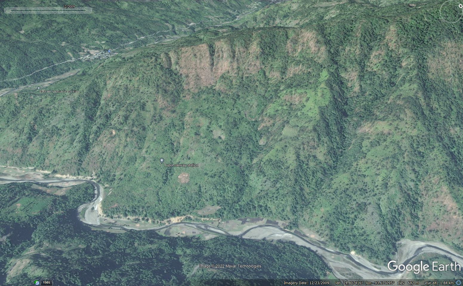
The site of the 30 June 2022 Tupul landslide in Manipur, India. Google Earth image from 2009.
.
I was a student of the wonderful Professor Denys Brunsden, a pioneer of applied geomorphology. He encouraged us to learn to read the landscape as the landforms indicate past and ongoing processes. At this site, there are multiple elements that to me indicate the likelihood that this slope is a relict (ancient) landslide. For instance, I would worry a great deal about those very steep slopes near to the ridge – does this indicate that material has slipped to expose them? Look at the uneven topography on the midslopes – could that be an indication of material deposited in a previous landslide? Why does the river have that sharp pair of bends on the left side of the image? Is this an indication that it has been pushed over by a landslide? Indeed, doesn’t the section of slope on which Tupul railway station is located look like an earthflow?
Is there a sign of a secondary failure in the slopes above the railway station – possible an arcuate but vegetated scarp?
If this is true then the slope on the left of the section is of particular concern. The river is actively eroding the toe and it is steeper than the adjoining slopes. There may be some signs of instability on the lower slope.
Of course all of this needed to be confirmed with detailed mapping from aerial photographs and on the ground, including analysis of the materials. Was that analysis undertaken, I wonder?
But once you are sensitised to the possible landforms at this site the construction approaches start to look somewhat courageous:-
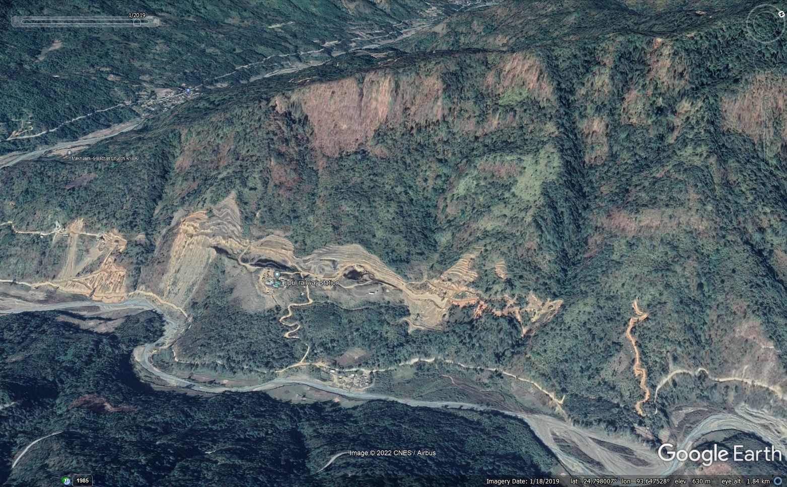
The site of the 30 June 2022 Tupul landslide in Manipur, India. Google Earth image from January 2019.
.
Look in particular at the area around Tupul railway station, where the landslide occurred, this time from an overhead view:-
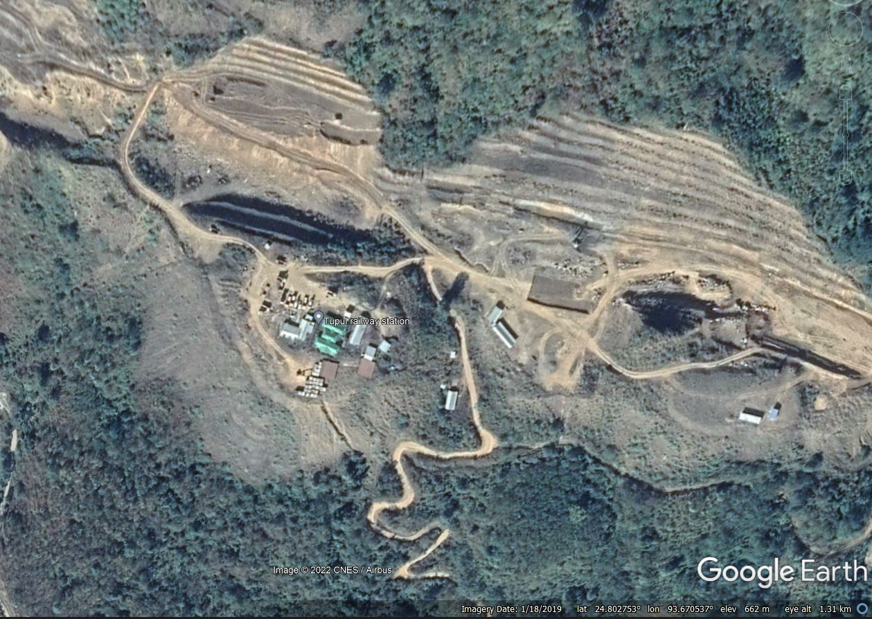
The site of Tupul railway station, part of the 30 June 2022 Tupul landslide in Manipur, India. Google Earth image from January 2019.
.
The lobe that I identified as a potential earthflow has been cut, and the slope has been benched. Downslope, spoil has been tipped to create a bench, loading the lower slope. If this location was an ancient landslide then both of these acts could have potentially destabilised the slopes.
Of course once again this is speculation, and a proper investigation is needed. The Print reports that the Chief Minister of Manipur, N. Biren Singh, has indicated that “the tragedy necessitated a “relook” at the railway project.”
“The Manipur hill soil is very soft, the railway people have the expertise, but unfortunately this kind of incident has taken place and they need to relook… this target of railway reaching Imphal by December 2023 will be delayed,” he had said.
I am unsure what a “relook” actually means. I hope it indicates a detailed investigation as to what caused the Tupul landslide, and a lessons learnt for the remainder of the railway alignment. Time will tell.
 Dave Petley is the Vice-Chancellor of the University of Hull in the United Kingdom. His blog provides commentary and analysis of landslide events occurring worldwide, including the landslides themselves, latest research, and conferences and meetings.
Thanks for sharing your expertise-view in this topic.
We can help a lot by getting 1-2 IBIS GBSAR systems onsite for operational safety support and monitoring… helping identify areas of displacement and increasing velocity.
We did this for Caltrans and John Madonna Construction on CA-1 after the Mud Creek event and remediation, mitigation, and reopening months ahead of schedule and no injuries….
Thanks . Keep the study on please . Looks like that with greater precautions and concern backed by technology and a seasoned consultant, this tragedy was perhaps avoidable .Was completion date being pushed for an earlier date ? Hope a detailed study is done and corrective action taken . Precious lives lost.
It certainly looks like they were planning to punch a straight shot through the middle of that old slide mass, rather than work with the topography better. Good planning may have taken a back to regional politics in this case.