
4 July 2022
Tupul: a landslide disaster in Manipur, India
Posted by Dave Petley
Tupul: a landslide disaster in Manipur, India
On 30 June 2022 a very large landslide occurred at Tupul in Noney district of Manipur in Northern India. As of 3 July 2022 the confirmed toll was 42 people, with a further 20 people reported to be missing. A total of 18 people have been rescued. The majority of the fatalities consisted soldiers who were accommodated on the site of the landslide, with reports that they were from the 107 Battalion of the Territorial Army. The prospect of any further survivors is extremely low.
The best image that I have seen of the landslide was tweeted by Karma Paljor:
The disaster site #ManipurLandslide from across the river. The rescue teams have a daunting and painful task ahead pic.twitter.com/q2UQrLyw6A
— Karma Paljor (@Karma_Paljor) July 1, 2022
.
There is also good drone footage on the following Youtube video (which has some annoying music):-
.
The drone footage confirms that the valley is not blocked by the landslide, which was an earlier concern. Indeed, it shows operations underway to widen the spillway.
The location of the landslide is 24.804, 93.674. The Google Earth image below shows the site on 24 March 2021:-
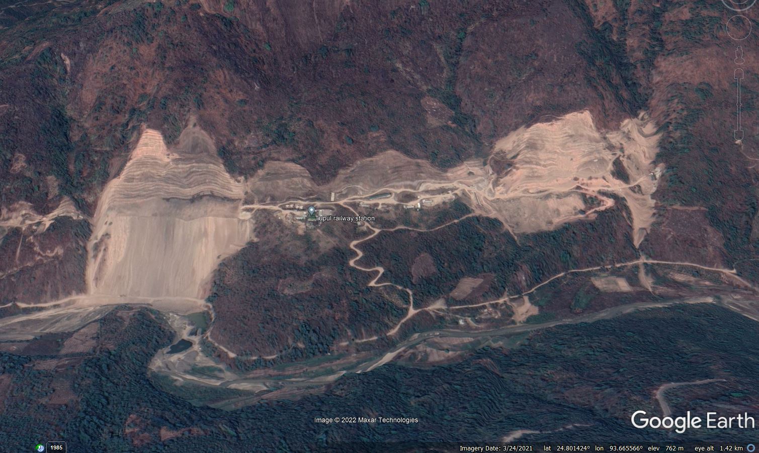
Google Earth image of the site of the 30 June 2022 Tupul landslide in India.
.
The image shows extensive slope works being undertaken at Tupul – this is for the construction of the Jiribam to Imphal railway line, which is planned to be completed by December 2023. Some of the works shown in the image appear to demonstrate questionable construction approaches, including large amounts of sediment being released into the river system.
The section of slope that has failed is shown below:-
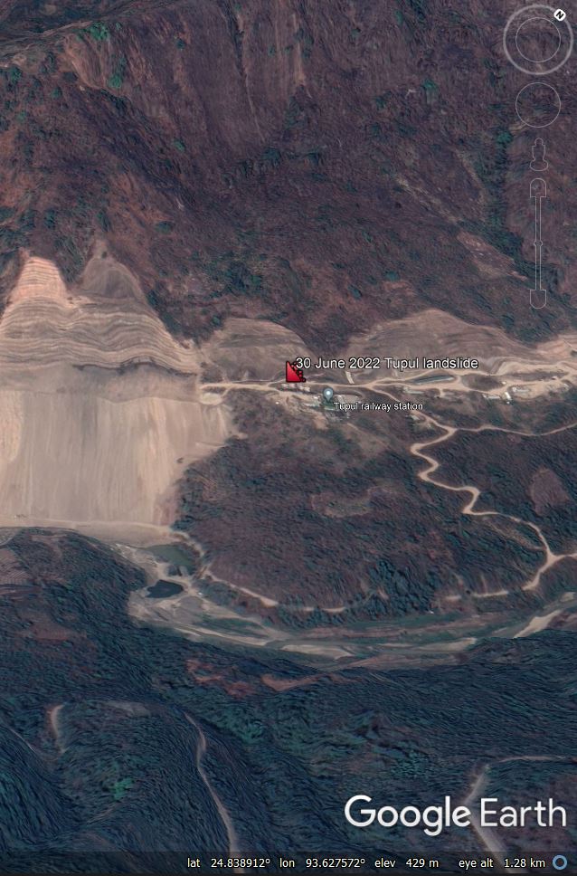
Google Earth image of the section of slope that failed during the 30 June 2022 Tupul landslide in India.
.
There are a number of aspects of this site, prior to the failure, that give me cause for concern, including the very steep upper part of the slope, the lobate form of the lower slopes and the large bend in the river. I would like to see the engineering geomorphological and geological interpretation of this site that was surely (?) undertaken prior to construction.
The section that has collapsed had been cut, so inevitably this must be the leading potential cause of the landslide. The width of the landslide appears to correspond closely to the section of cut slope, which may be an indication of process and causation. I have tried to annotate the image from Karma Paljor to indicate the main features – of course this is highly speculative:-
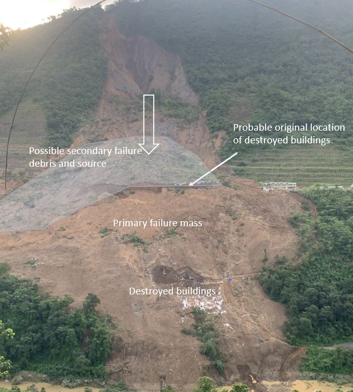
A speculative interpretation of the main features of the Tupul landslide, based on the image tweeted by Karma Paljor.
.
My initial (speculative) interpretation is that the cut slope failed, creating the large debris mass seen in the foreground of the image. The location of the destroyed buildings gives a sense of the movement direction and distance. The area that I have shaded appears to be a secondary failure from higher up the slope, probably because of a loss of support. This is a deep seated collapse that may have implications for the stability of the other parts of the slope. This scar has then been partially infilled by smaller failures around the steep backscarp. These are likely to continue for some time.
Note the water flowing down the rear scarp. The main part of the SW summer monsoon will occur over the coming weeks. A key concern right now must be the stability of the other cut slopes at this site.
Finally, it goes without saying that this landslide should be investigated independently and in a transparent manner, with the outcomes published and lessons learnt.
 Dave Petley is the Vice-Chancellor of the University of Hull in the United Kingdom. His blog provides commentary and analysis of landslide events occurring worldwide, including the landslides themselves, latest research, and conferences and meetings.
It goes without saying that this whole construction project needs strategic and tactical Radar monitoring, I do not understand why a country would put their people, and Service members at risk like this. This line will deteriorate and be the scene of many accidents to come. It clearly need full time monitoring …. HELLO it is 2022 and all these options are available at LOW cost. Much cheaper than 10s of souls lives, family, colleagues etc ..
If anyone is interested we can address this in short fashion and help secure the work area assessments, investigation teams and the remaining project efforts @ [email protected]
There’s what appears to be footage from immediately after the slide here (Dust still lingering in the air and shows the river completely blocked as well as it starting to spill over the blockage later in the video) https://www.youtube.com/watch?v=I2E3wntdeBI
And this is from one of the First news teams that got to the site, including a close up pan of the failure (you can still see small dirt falls coming down from the top) https://www.youtube.com/watch?v=sU73GnFctRU
That Google Earth imagery certainly has all the features of a large not-so-dormant slide complex: Scoop out of the mountainside, break in slope with broad lobe of apparent slide material that has displaced the channel a considerable distance to the ESE. I’d map it as a slide just from Google.
Wow.. Development for a railway accelerates what nature would do periodically in such a valley. What a disaster waiting to happen and reoccur. Sorry for all the lives lost. Even just the most recent slide being undercut by the river meander is shown well by google earth. A lot of slope stabilization and monitoring and river erosion cladding would be needed to even consider this will not be a long term continuing problem. The loss of vegetation will only make the rainfall impacts worse. Engineers can do amazing tasks, but this will need a great amount of effort. Plan on more rain and more intense rain and runoff not less. You will need the best of the best to get this under control and not have further flooding and landslides. Take care and I hope you can get those slopes revegetated and somehow stop the slopes from failing. A big ongoing dangerous task – spread across so many areas with new development. Is a railroad really needed there?
The Railway line project had no Environment Impact Assessment, no Social Impact Assessment, no disaster potential assessment, violations, warnings from GSI and also a pending case in National Green Tribunal. Some details can be seen here: https://sandrp.in/2022/07/02/manipurs-ejei-river-blocking-landslide-at-under-construction-railway-line-involved-violations-no-eia-ngt-pending-case/
Very unfortunate. Geologically speaking, it there was an active fracture line along the river that took a sharp 90 degree turn?
The Northeastern India is among the regions in the world where both precipitation and temperature have increased (Jan 2021 – Aug 2021) to the highest levels (reference period 1951 – 2010). This confluence of impacts of climate change is conducive to more severe extreme events, in particular landslides in the sub-Himalayan region, such as in Tupul in Manipur. I was in Imphal this summer (May-June) as a Fulbright fellow and collaborated with colleagues at the Research Institute of Science and Technology, Imphal, on developing a strategy for research focused on resilience and policy guidelines for such hazards. This is a challenging endeavor but one that can not be avoided.