
25 February 2022
Lyneham – an interesting landslide from the south of England
Posted by Dave Petley
Lyneham – an interesting landslide from the south of England
Yesterday the BBC reported on another serious landslide triggered by the heavy rainfall that fell across the UK last week. This landslide has caused very significant damage to the B6049 road near to the village of Lyneham in Wiltshire. The location is 51.517, -1.991. The BBC has this image of the aftermath of the landslide:-
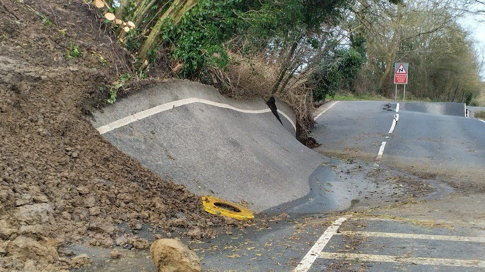
Landslide damage to the B4069 in Lyneham, Wiltshire. Image from the BBC.
.
It is clear that there has been very substantial vertical movement on the slope. Interestingly, a Google StreetView image of the road suggests that it was undergoing considerable distress back in October 2021:-
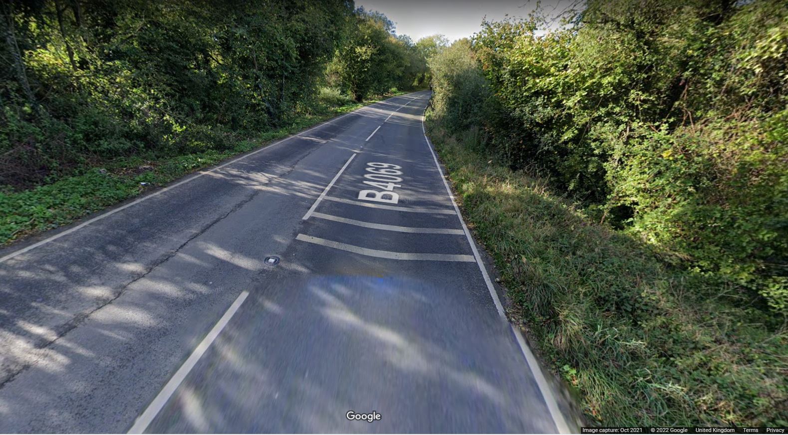
Google StreetView of a section of the B6049 near to Lyneham, showing extensive cracking in the road.
.
This crack appears to indicate extension, which is consistent with the deformation observed in the failure last week.
Google Earth has good imagery of the site. This image was collected in April 2021:-
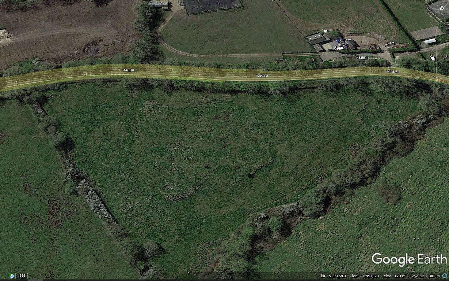
Google Earth image of the site of the landslide at Lyneham in southern England. Note the relict solifluction feature in the field downslope of the road.
.
In the field downslope of the road (nearer to the camera) there is a clear large, shallow landslide lobe. There is a further lobe to the right of the image, emerging from the same morphological feature. I would interpret this as probable ancient solifluction landslide – an active layer detachment – left over from the period when this area was affected by permafrost conditions during Pleistocene “Ice Age”. These features are common in southern Britain. Note also that upslope of the road there appear to be some features that could be tension cracks in the field.
There are similar lobes in some of the other fields too.
So the most likely explanation for the landslide near to Lyneham is that it is a reactivation of a pre-existing failure, probably a solifluction landslide, caused by the exceptional rainfall that we are now experiencing. Of course a detailed site investigation is needed to verify this initial hypothesis.
It will also be interesting to find out whether this is simply the results of increased rainfall or whether some other change has occurred in the area, such as a modification to the drainage. Are there signs of some construction activity in the field in the top left corner, for example? Without a detailed investigation it is impossible to know if this could have been a factor.
 Dave Petley is the Vice-Chancellor of the University of Hull in the United Kingdom. His blog provides commentary and analysis of landslide events occurring worldwide, including the landslides themselves, latest research, and conferences and meetings.
Lyneham is in Wiltshire.
[Apologies, now corrected. The BBC article reports this as being in Oxfordshire: https://www.bbc.co.uk/news/uk-england-wiltshire-60490051 D.]
This ‘creep’ has been going on for years. I moved to this area in 1973 and I was told about it then. There has been a huge amount of research and many papers written, mainly by academics at Bristol University. I don’t recall any time when I have drive up or down ‘Lyneham Banks’ when there was no cracks in the road surface, but I have never seen it as bad as shown in the photograph.
Until recently (less than 10 years ago) RAF Lyneham was on top of this slope, but I can’t recall anyone ever saying that it caused problems with the runways. It is now the main training school for the Royal Electrical & Mechanical Engineers (REME)
I’m sure there’ll be more, but first reports of landsides in the huge rain event here in Australia
https://www.msn.com/en-au/news/australia/landslide-at-northern-rivers-town/vi-AAUuPGP?ocid=entnewsntp
All of these areas easily a part of L-Band or S1 satellite data acquisition scenarios. If “they” want to monitor them it is affordable and possible. Mitigation planning alone, can benefit significantly …from these wide area views with key corridors in consideration.
Rapid adaptation to the new topography along the stretch of road affected …
https://www.theguardian.com/uk-news/2022/mar/07/wiltshire-road-becomes-a-skate-park-after-it-cracks-and-buckles
Funnily enough, something has been going on in the top field – vegetation clearance, construction of a new house(?): https://www.youtube.com/watch?v=jh1OAb_i39Q
Yes there are old coalmines underneath that is for sure cause effect of landslide
https://www.mindat.org/feature-2643298.html
@Karen, that is not correct,