
6 July 2021
The source zone of the Atami landslide
Posted by Dave Petley
The source zone of the Atami landslide
The recovery efforts at the site of the Atami landslide continue. At the time of writing four bodies have been recovered and a further 24 people remain missing. This is substantially lower than we feared yesterday.
Meanwhile, there is now considerable focus on the cause of the landslide. The Japanese newspaper The Asahi Shimbun has a good article suggesting that inadequate drainage in a fill slope at the landslide source may have been a factor. The article details a troubled history of the site from 2006, with allegations of unauthorised dumping of industrial materials and an abandoned development project.
The Google Earth image archive gives some support to the idea that the slope that failed was manmade. This is the most recent image of the source zone:-
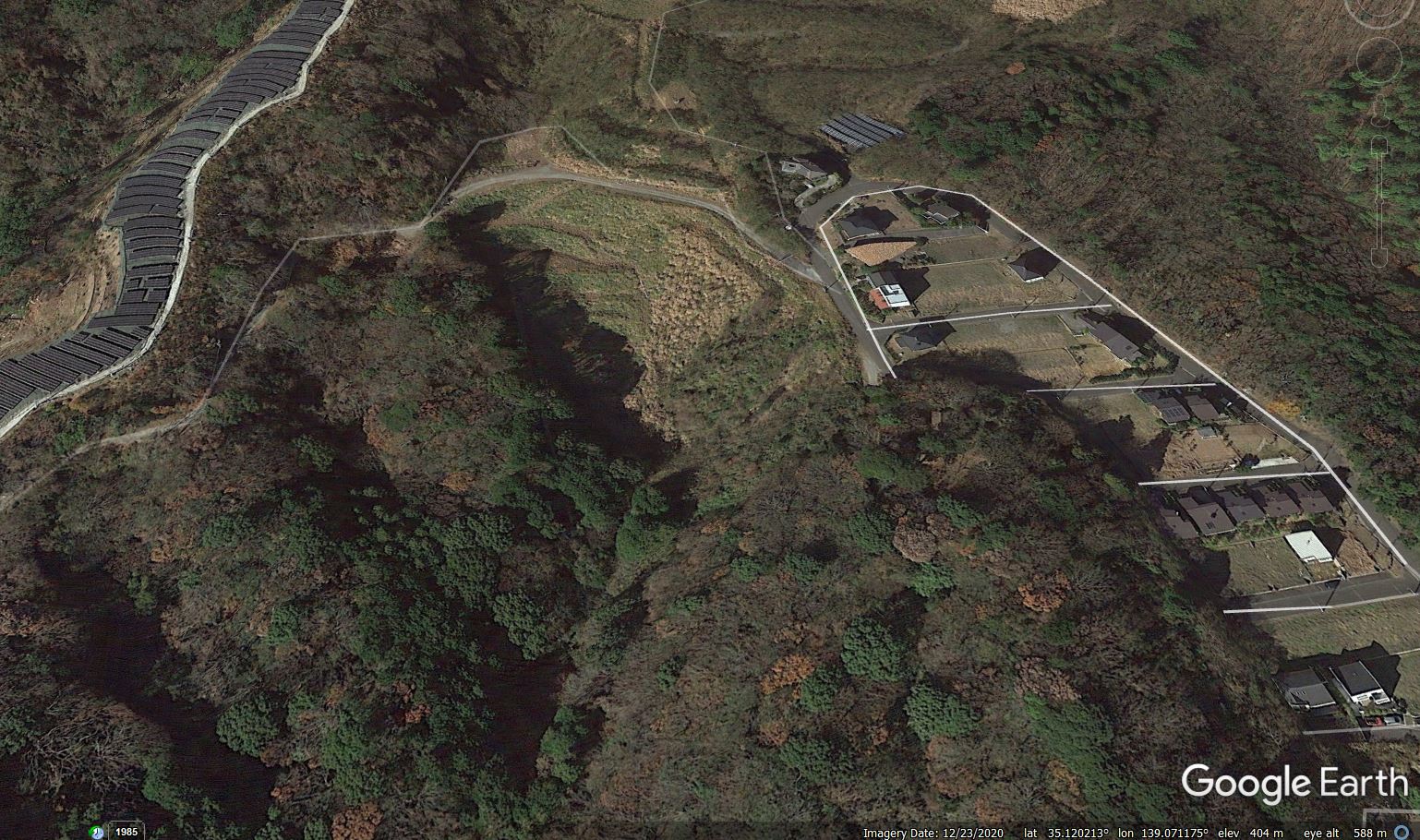
Google Earth image of the source zone of the Atami landslide in Japan. This image is dated 23 December 2020.
.
The bend in the road is clearly supported on a filled slope that is benched. This is more clear in the first image in the archive, which is dated 31 January 2011:-
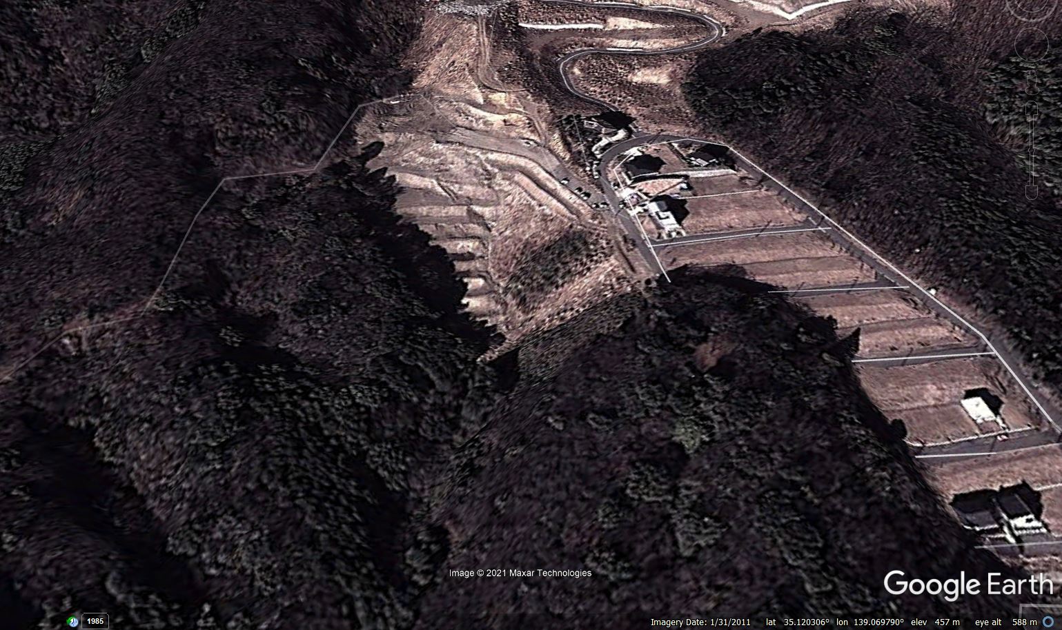
Archive Google Earth image of the source zone of the Atami landslide in Japan. This image is dated 31 January 2011.
.
This appears to be the period in which active construction had been recently occurring – The Asahi Shimbun story states that:
In February 2011, the owner of a Tokyo-based holding company that included a construction company among group firms, purchased the site. Complying with city government instructions, the site was filled in with the leftover dirt left in the area.
Although I must note that “a lawyer for the company owner denied having the area filled in with dirt and soil”.
The 2011 image appears to show a slope that has been artificially constructed, with clear terraces. Almost all of this made ground is absent in the drone video:-
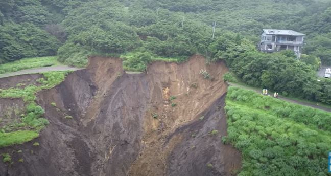
The source area in the aftermath of the Atami landslide in Japan. Still from a video posted to Youtube.
.
I noted yesterday that the failure was surprisingly deep-seated. Perhaps we know the reason now.
Catastrophic fill slope failures are well documented. For example, I blogged about a large scale failure in fill at Yeager airport in West Virginia in 2015. In conditions of high saturation, fill slope failures can transition into the type of violent mudflow that occurred at Atami.
Of course at this stage I can only speculate on the cause, but the investigation will undoubtedly take a close look at the design, construction and maintenance of that fill slope, and in particular on the compaction of the materials and the presence or absence of appropriate drainage.
 Dave Petley is the Vice-Chancellor of the University of Hull in the United Kingdom. His blog provides commentary and analysis of landslide events occurring worldwide, including the landslides themselves, latest research, and conferences and meetings.
daily mail UK said so, man made disaster. Insert Atami in search daily mail, some solar plant nearby they developed land.
Whereas all globalist Western news advertised the disaster as global warming CO2 bs, thus heavier monsoon rains…thus slide…
[It can be both, they are not mutually exclusive. Both are anthropogenic, so part of the same issue. D.]
and the reason it is a “surprise” is that there was no monitoring on the site — at least no data has come to light. Japan has ALOS2 data and a satellite for this very purpose — for geohazards … but maybe not for mangeohazards. …
Dave,
Have you seen this?
https://www.bbc.co.uk/news/av/world-asia-india-57964308