
8 April 2021
InSAR as a wide area landslide detection tool
Posted by Dave Petley
InSAR as a wide area landslide detection tool
The development of Satellite Inferometry (InSAR) in the last two decades has provided a new tool for the detection of landslide movements. In general the application has been to specific settings – montoring the movement of a known landslide or of mine waste for example. Sometimes InSAR is used for near real time monitoring, on other occasions it has been applied to look at the development of a failure that has already happened. The tool is new and quite experimental, but it is making the transition to practise.
One of the potential opportunities for InSAR is to be able to detect deformation over large areas. National InSAR maps are now available – the best example is in Norway. The question that this poses is whether this type of approach could be used to detect the early signs of movement of potentially hazardous but hitherto unknown failures – an obvious example being the Chamoli landslide in India earlier this year. But there are many complexities involved, some of which are quite challenging – for example, the impacts of geometric distortion and of vegetation growth, both of which might degrade the signal.
A new paper has just been published in the journal Landslides (Wang et al. 2021) that explores this approach. The authors have looked at Shuicheng County in Guizhou Province in China as an example. This area is interesting as located within it is the Jicangzhen landslide, which killed around 45 people on 22 July 2019.
The authors found that after analysis the InSAR technique allowed them to identify six large, actively deforming landslides. In these cases they were able to extract a time series of movement of the slope, suggesting that the technique is potentially applicable as an early warning system, as the image below, from the paper, shows:
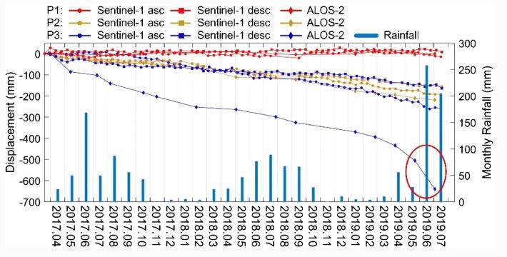
Time series data for three of the landslides in the study area, from Wang et al. (2021). The Jichangzhen landslide is point P1.
However, interestingly, no precursory deformation was detected for the Jicangzhen landslide itself (the red lines on the graph above). In this case the technique would have been of no use. But, the authors point out that this landslide was triggered by short duration, heavy rainfall and possibly by human activity:
Considering the meteorological conditions and optical satellite images at that time, we conclude that short-term heavy rainfalls triggered the Jichangzhen landslide, as well as the road construction or maintenance may change the slope stability.
The image below, from Wang et al. (2021), provides an aerial view of the Jicangzhen landslide. At the top of the slope is a road – note that the authors have identified the source area as being located above that highway. At the time of the event I suggested that this landslide might have been triggered by a smaller failure in the upper reaches of the slope. The InSAR data appears to strengthen the argument that in this case the slope was destabilised by slope cutting for the road, and then triggered by exceptional rainfall. The debris loaded the slope below the road, generating a massive failure.
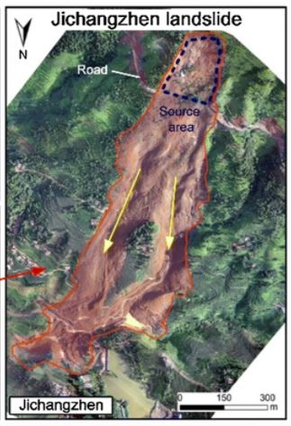
Aerial image of the Jichangzhen landslide in China, from Wang et al. (2021).
.
In cases like this there is unlikely to be precursory deformation, such that InSAR is unlikely to work. Thus, the paper provides a really elegant illustration of both the potential of the technique and its likely limitations.
.
Reference
Wang, Y., Liu, D., Dong, J. et al. 2021. On the applicability of satellite SAR interferometry to landslide hazards detection in hilly areas: a case study of Shuicheng, Guizhou in Southwest China. Landslides. https://doi.org/10.1007/s10346-021-01648-y
 Dave Petley is the Vice-Chancellor of the University of Hull in the United Kingdom. His blog provides commentary and analysis of landslide events occurring worldwide, including the landslides themselves, latest research, and conferences and meetings.
NO LIMITATIONS Appropriate use of Satellite and ground based tools in concert .. I do not know why this is hard to figure out. We have been doing it here in Oregon, USA for over a year, and in many other locations at one time or the other for years..
Vertical thinking of approaches and results from academic exercises is not due diligent.
One technique or one instrument only examples .. are not due diligent. if you are not using these tools and traditional methods together from your toolkit to make a difference and #MONITOR for #safety and #assurance …. I am not sure what you are doing.