
10 March 2021
The evolution of landslides after the 2015 Mw 7.8 Gorkha, Nepal earthquake
Posted by Dave Petley
The evolution of landslides after the 2015 Mw 7.8 Gorkha, Nepal earthquake
An ongoing area of discussion in landslide research is the evolution of slopes in the aftermath of earthquakes. it is well-established that large earthquakes in upland areas trigger large numbers of slope failures, in some cases casing extremely high levels of loss. It is also known that the first very heavy rainfall event after an earthquake in a mountainous area is often associated with further very high levels of landsliding – an issue that we highlighted in a paper in the aftermath of the 1999 Chi-Chi Earthquake in Taiwan (Lin et al. 2006).
Presumably after an earthquake the landscape should return to some sort of equilibrium, with the number of landslides active each year reducing with time, on average. But how quickly this occurs is poorly constrained. It might of course vary from place to place according to the climate, geology, vegetation and human activities. This is not a purely academic issue – this effect strongly determines the hazard posed by mountain communities after an earthquake.
In an open access paper just published in the journal Progress in Disaster Science (Rosser et al. 2021), a multidisciplinary team has examined this question with respect to the 2015 Mw 7.8 Gorkha, Nepal earthquake. They have focused on an area heavily affected by landslides in central and western Nepal. There is a great deal of richness in this paper, which also looks at risk management with mountain communities. However, in this post I will focus simply on the question of post-earthquake slope evolution.
The team has mapped landslides in a large study area on multiple occasions since the Gorkha Earthquake. In particular, they have manually mapped landslides twice per year since 2015, before and after the annual monsoon. The area chosen is a large swathe of west and central Nepal. This allows them to compile the following, critically important, diagram showing the trend in landslide occurrence in the landscape with time:-
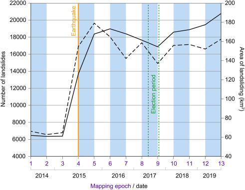
Changes in mapped landslide numbers and total landslide area between 2014, the Gorkha earthquake in 2015, and post-monsoon 2019, from Rosser et al. (2021). Vertical blue bars show the timing of the monsoon; solid black line is landslide number; dashed black line is landslide area; and, the time of the earthquake (orange line) and the first local elections (green lines).
.
The jump in the number and area of landslides caused by the Gorkha Earthquake in 2015 is clear. As expected, this increases further in the monsoon that year. Interestingly, the number of landslides increased again slightly through the dry season in the winter of 2015-16, which is slightly surprising. After this there was a slow decline in the number of landslides, although this was a quite marginal change, much less than has been seen elsewhere.
Fascinatingly, the area and number of landslides increases markedly again from 2017 onwards, which is definitely unexpected. Rosser et al. (2021) suggest that this is due to a “proliferation of rural road construction around the time of the first local elections”. The number of landslides in the study area is now in excess of 21,000, more than on the day after the earthquake and after the first monsoon season.
I have highlighted ad nauseam the terrible costs of unconstrained rural road construction in high mountain areas. In the aftermath of the Gorkha Earthquake, Rosser et al. (2021) have demonstrated well that in central and western Nepal, rural roads are serving to amplify the impacts of the seismic shaking, and to extend them in time.
.
References
Lin, J-C, Petley, D.N., Jen, C-H., Hsu, M-L. 2006. Slope movements in a dynamic environment – A case study of Tachia river, Central Taiwan. Quaternary International, 147 (1), 103-112.
Rosser, N., Kincey, M., Oven, K. et al. 2021. Changing significance of landslide Hazard and risk after the 2015 Mw 7.8 Gorkha, Nepal earthquake, Progress in Disaster Science, 100159, https://doi.org/10.1016/j.pdisas.2021.100159.
 Dave Petley is the Vice-Chancellor of the University of Hull in the United Kingdom. His blog provides commentary and analysis of landslide events occurring worldwide, including the landslides themselves, latest research, and conferences and meetings.