
9 June 2020
Landslides triggered by the Mw = 7.8 14 November 2016 Kaikoura earthquake: an update
Posted by Dave Petley
Landslides triggered by the Mw = 7.8 14 November 2016 Kaikoura earthquake: an update
The 14 November 2016 Kaikoura earthquake in New Zealand was the result of a complex fault rupturing process in a mountainous environment. Unsurprisingly, an earthquake of this size generated a large number of landslides. I have blogged about these landslides previously, and have also posted images of some of them.
Mapping the resultant landslides has been a huge task led by a team from GNS Science in New Zealand. Earlier papers had been based on initial mapping, including about 10,000 earthquake triggered landslides. In a paper just published in the journal Landslides (Massey et al. 2020) the team have provided an update based on a full inventory. This may well be the most detailed earthquake induced landslide inventory compiled to date. There is fantastic data on both the fault ruptures at Kaikoura and the resultant ground motion, meaning that this dataset can provide great insight on earthquake – landslide interactions.
The headline figure is remarkable. The earthquake (and its aftershocks) triggered 29,557 landslides, all of which have been mapped and digitised by hand. This is the resultant map of the landslides, with the faults that ruptured to generate the earthquake marked in red:-
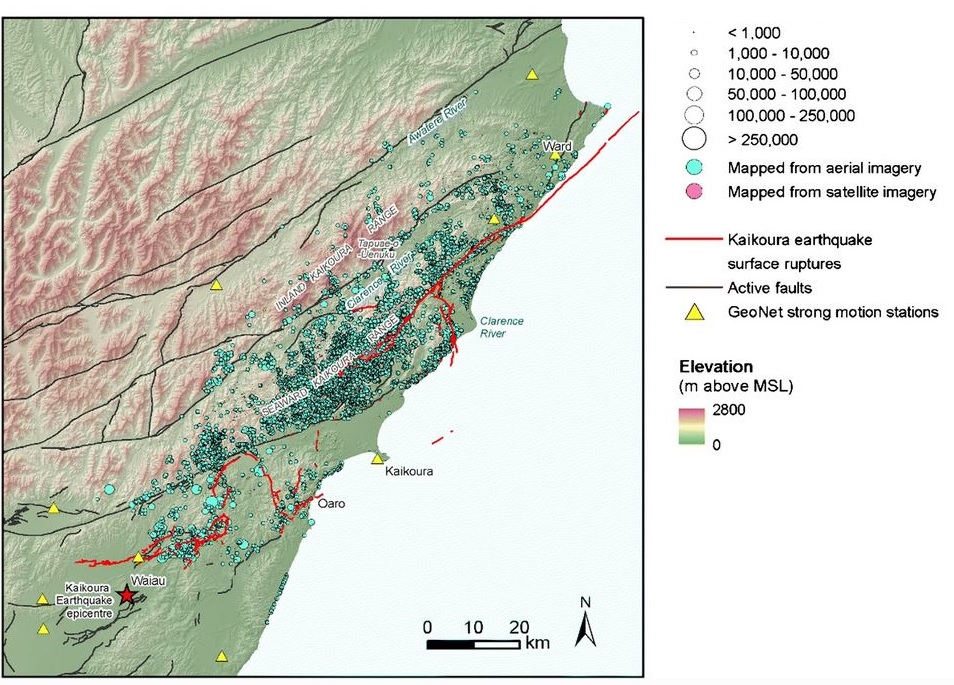
Map of the distribution of landslides triggered by the 2016 Kaikoura earthquake in New Zealand. Map from Massey et al. (2020).
.
There are some interesting take home messages from this study. The most important is from the analysis of the factors controlling the distribution of the mapped landslides triggered by the Kaikoura earthquake. Having assessed various factors, Massey et al. (2020) conclude that the key variable is distance to the surface fault rupture – indeed this predicts the density of landslides better than does the measured and modelled peak ground accelerations. This is not the first study to conclude that proximity to the fault is important, but the quality of this dataset gives the results additional weight. The debate continues as to why this is the case – distance to fault must in reality be a proxy for a physical parameter (or set of physical parameters) that are controlling slope behaviour. What are these parameters?
Other factors that are important in determining slope behaviour from the Kaikoura earthquake are easier to understand, and include the geology (i.e. material strength), the slope angle, the local slope relief and the peak ground velocity.
One nice aspect of this study is that it finishes with some recommendations for future research – I welcome this. Massey et al. (2020) suggest that fruitful avenues might include 1) investigations of the interaction between surface fault rupture, earthquake-induced ground shaking, and the initiation of slope failure; and 2. remodelling of the ground motions caused by the multiple fault ruptures.
.
On reflection 1: Landslides in Space 1
An interesting article on the Forbes website discusses the role of landslides in generating the trails of dust that flow behind comets.
.
On reflection 2: Landslides in Space 2
A global map of rockfalls on the moon, produced by a team from ETH.
.
Reference
Massey, C.I., Townsend, D.T., Lukovic, B. et al. 2020. Landslides triggered by the MW7.8 14 November 2016 Kaikōura earthquake: an update. Landslides. https://doi.org/10.1007/s10346-020-01439-x
 Dave Petley is the Vice-Chancellor of the University of Hull in the United Kingdom. His blog provides commentary and analysis of landslide events occurring worldwide, including the landslides themselves, latest research, and conferences and meetings.