
16 March 2020
An analysis of the Piz Cengalo landslide
Posted by Dave Petley
An analysis of the Piz Cengalo landslide
In August 2017 a large landslide initiated on the Piz Cengalo mountain in Switzerland. It travelled 6.5 km before striking the village of Bondo. In total it was responsible for eight fatalities.
In an article just published in the journal NHESS, which is open access, Mergili et al. (2020) provide a detailed description and simulation of the landslide. The first part of the paper provides a really good description of the event. The landslide was initiated at 09:31 local time on 23 August 2017 when about 3.6 million cubic metres broke off from the eastern face of Piz Cengalo. The sequence of events is shown in the images below, from Mergili et al. (2020):-
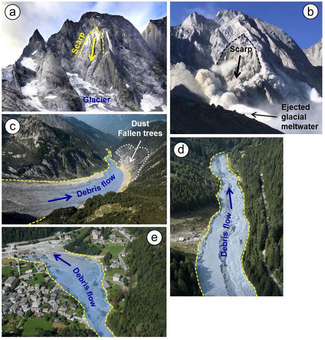
The sequence of events for the Piz Cengalo landslide, from Mergili et al. (2020). Original caption:- The 2017 Piz Cengalo–Bondo landslide cascade. (a) Scarp area on 20 September 2014. (b) Scarp area on 23 September 2017 at 09:30 LT, 20 s after release, in frame of a video taken from the Capanna di Sciora. Note the fountain of water and/or crushed ice at the front of the avalanche, most likely representing meltwater from the impacted glacier. (c) Upper part of Val Bondasca, where the channelized debris flow developed. Note the zone of dust- and pressure-induced damage to trees on the right side of the valley. (d) Traces of the debris flows in Val Bondasca. (e) The debris cone of Bondo after the event. Image sources: © Daniele Porro (a), © Diego Salasc/Reto and Barbara Salis (b), and © swisstopo (c–e).
.
After detaching, the landslide impacted the glacier below and entrained about 600,000 cubic metres of ice. In a manner that was similar to the Mount Haast landslide, the mass behaved initially as a rock avalanche. However, downstream it evolved into a debris flow that swept down the valley to strike the village of Bondo. Over the next day or so a series of nine debris flow surges struck the village.
Interestingly, two different scenarios have been proposed to explain the behaviour of the landslide, and in particular the formation of the first debris flow. These are described in the schematic diagram below, from Mergili et al. (2020):-
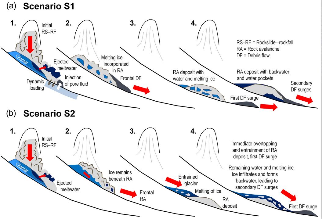
The two scenarios for the behaviour of the Piz Cengalo rock avalanche, from Mergili et al. (2020).
.
In the first scenario (S1), the front of the rock avalanche became highly saturated, and transitioned into the first debris flow. In the second (S2), the rock avalanche stalled mid-valley, but was overtopped by an avalanching flow of entrained ice and rock fragments, to form the debris flow.
Mergili et al. (2020) have attempted to simulate these two scenarios. Interestingly, the models indicate that both are plausible, and the simulations do not allow us to determine which is likely to be correct.
The behaviour of these complex landslides remains challenging to understand and model, but is really important if future hazards are to be understood. The impacts of global heating, which are increasing the frequency of these large events, means that this remains a really important research question.
Reference
Mergili, M., Jaboyedoff, M., Pullarello, J. and Pudasaini, S. P. 2020. Back calculation of the 2017 Piz Cengalo–Bondo landslide cascade with r.avaflow: what we can do and what we can learn. Natural Hazards and Earth System Sciences, 20 (2), 505-520. DOI: 10.5194/nhess-20-505-2020.
 Dave Petley is the Vice-Chancellor of the University of Hull in the United Kingdom. His blog provides commentary and analysis of landslide events occurring worldwide, including the landslides themselves, latest research, and conferences and meetings.