
19 November 2019
Landslides triggered by the Mw=7.8 Haida Gwaii earthquake in Canada
Posted by Dave Petley
Landslides triggered by the Mw=7.8 Haida Gwaii earthquake in Canada
On 27 October 2012 the Mw=7.8 Haida Gwaii earthquake struck off the coast in British Columbia in Canada. This was a shallow earthquake with a dominantly thrust-type mechanism, which would be expected to generate substantial numbers of landslides if it occurred directly under hilly terrain. In this case, a comparatively small area of Haida Gwaii (formerly the Queen Charlotte Islands) was affected by significant shaking. The impacts in terms of landslides are documented in a new paper (Barth et al. 2019) published in the journal Landslides. This is a particularly interesting case as the study area, which extends over about 1350 km2, consists of undisturbed, forested hillsides. This is important for two reasons:
- It removes the effects of human activity on landslide susceptibility, giving a dataset that is less complex to interpret than has been the case elsewhere;
- The contrast between native forest and the bear rock / soil of a landslide makes mapping comparatively straightforward using satellite imagery.
Thus, this is a key event for understanding the landslide impacts of large earthquakes.
In total Barth et al. (2019) have mapped 244 landslides triggered by the earthquake. The authors provide an example of these landslides in the area of Gowaia Bay in Haida Gwaii:-
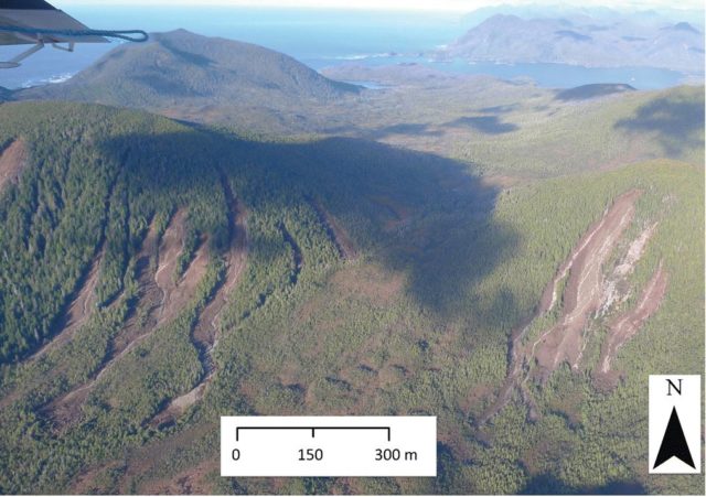
Landslides from the Mw=7.8 Haida Gwaii earthquake. Image from Barth et al. (2019).
.
Barth et al. (2019) have looked at multiple epochs of satellite imagery, and examined the rates at which landslides occur. They find that:
- Prior to the earthquake, the average rate was 1.44 new landslides per year per 100 km2 in the study area;
- The 244 landslides triggered in the earthquake dramatically increases this to 18.1 new landslides per year per 100 km2
- In the three years after the earthquake the rate of new landslides decreased to 1.93 per year per 100 km2
- And finally, in the period from 2016 to 2018 this reduced to 1.0 new landslides per year per 100 km2.
So, it is clear that the earthquake caused a very dramatic spike in the landslide rate and, as has been established elsewhere, an above average rate continued in the post-seismic period, before settling back down to the background rate. This is a dataset that should allow a more detailed understanding of the control on landslides from different physical parameters, and thus it is an important new dataset in the growing catalogue of coseismic landslide inventories.
Reference
Barth, S., Geertsema, M., Bevington, A.R. et al. 2019. Landslide response to the 27 October 2012 earthquake (MW 7.8), southern Haida Gwaii, British Columbia, Canada. Landslides. https://doi.org/10.1007/s10346-019-01292-7
 Dave Petley is the Vice-Chancellor of the University of Hull in the United Kingdom. His blog provides commentary and analysis of landslide events occurring worldwide, including the landslides themselves, latest research, and conferences and meetings.
Typo in the bullet that starts “The 244 earthquakes triggered in the earthquake …”
You want “244 landslides”
[Thanks, now corrected. D.]