
28 October 2019
Gongo Soco: continued deformation of the slope of a high wall mine in Brazil
Posted by Dave Petley
Gongo Soco: continued deformation of the slope of a high wall mine in Brazil
In the aftermath of the two disastrous tailings dam failures in Brazil, mining company Vale continues to undertake a massive programme of evaluation of the stability of its facilities. According to Mining Magazine, this programme is costing $1.7 billion in the first instance. In early October, the company reported on its progress to date, noting that several facilities continue to cause concern, although they are being actively managed.
One facility that continues to cause concern is at the massive Gongo Soco mine, which is located at -19.957, -43.599. Here, a high wall rock slope on the mine side is actively deforming, raising concerns of a collapse that could displace mine waste, creating another tailings release downstream.
This is a Google Earth image of the site, taken on 1 June 2019:-
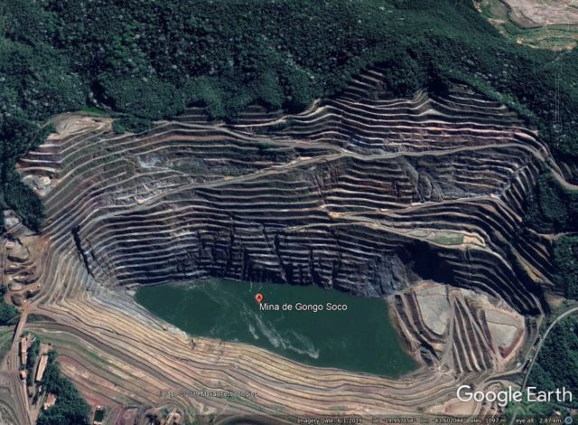
Google Earth image of the Gongo Soco mine. Image dated 1 June 2019.
.
Google Earth has a further image, dated 1 August 2019, which clearly shows the development of this large slope failure:-
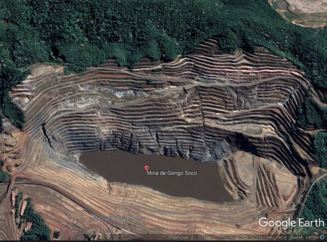
Google Earth image of the Gongo Soco mine. Image dated 1 August 2019.
.
Three things stand out here:
- The large fracture that has developed on the right side of the slope, from the fork in the road down to the corner of the lake. I would provisionally interpret this as the lateral margin of the active slide;
- The development of tension features at the back of the deforming block, most notable in the area above the lower track on the centre left of the image;
- General deterioration of the terraces, presumably as the rock mass deforms.
I have take a look at the most recent Planet Labs image of the site. The image below was collected on 18 October 2019 with the PlanetScope instrument. The resolution is lower than the Google Earth imagery, but the continued development of the slope is clear:-
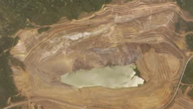
Planet Labs PlanetScope image of the Gongo Soco mine. Image dated 18 October 2019, copyright Planet Labs, used with permission.
.
On the image the lateral scarp on the right side has further developed, and there is now clear evidence of one on the left too. The rear scarp has developed significantly and there is clear evidence of further deterioration of the terraces as well. On the lower part of the slope a set of smaller landslides have developed, with a very notable feature in the central portion.
To manage the risk, the slope is being actively monitored, and a large wall is being constructed downstream to contain any debris in the event of a major collapse.
Reference
Planet Team (2019). Planet Application Program Interface: In Space for Life on Earth. San Francisco, CA. https://www.planet.com/
 Dave Petley is the Vice-Chancellor of the University of Hull in the United Kingdom. His blog provides commentary and analysis of landslide events occurring worldwide, including the landslides themselves, latest research, and conferences and meetings.