
2 April 2019
Tsangpo gorge: a first analysis of landslides triggered by the 2017 Ms=6.9 Milin earthquake
Posted by Dave Petley
Tsangpo gorge: a first analysis of landslides triggered by the 2017 Ms=6.9 Milin earthquake
On 18th November 2017 a shallow Ms=6.9 earthquake struck the Tsangpo Gorge area of Tibet. At the time I used satellite imagery from Planet Labs to show that the earthquake had triggered large numbers of landslides along the Tsangpo Gorge. Some of these were valley blocking, although fortunately the blockages proved to be short-lived. A paper (Hu et al. 2019) in the journal Landslides provides an analysis of the landslides triggered by the earthquake, based on mapping from satellite imagery.
In total, Hu et al. (2019) mapped 766 coseismic landslides, with a total volume of about 31 million cubic metres. Whilst this number seems small, the authors note that mapping with satellite imagery means that many of the smallest landslides will not be identified.
The authors have included the image below in the paper showing the landslides triggered by the earthquake. It is clear that there are clustered around the walls of the Tsangpo Gorge:-
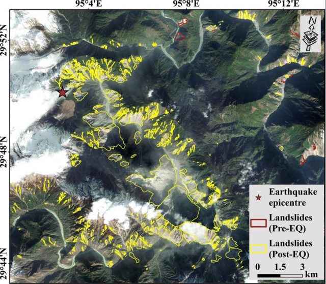
Landslides triggered by the the 2017 Ms=6.9 Milin earthquake in the Tsangpo gorge. Image from Hu et al. (2019).
.
Interestingly, Hu et al. (2019) note that the landslide distribution was dominated by the presence of the deeply-incised, V-shaped gorge rather than proximity to the fault (which is the case elsewhere). Thus, in this case, topography has been the controlling factor in landslide development.
In total, nine valley-blocking landslides developed in the earthquake, although only three lakes formed within the Tsangpo Gorge. These breached within a few days.
The authors highlight the increased likelihood of debris flows in this area in the aftermath of the eaethquake, in common with effects seen elsewhere. Interestingly, they also highlight increased risk of glacial debris flow events in the area. On 17th October 2018 such an event occurred downstream from the earthquake-affected area at Sedongpu. This event, which blocked the Tsangpo to a depth of 80 metres, had a volume of about 33 million cubic metres according to Hu et al. (2019). Ten days later a further glacial debris flow occurred at the same site.
Reference
Hu, K., Zhang, X., You, Y. et al. 2019. Landslides and dammed lakes triggered by the 2017 Ms6.9 Milin earthquake in the Tsangpo gorge. Landslides. https://doi.org/10.1007/s10346-019-01168-w
 Dave Petley is the Vice-Chancellor of the University of Hull in the United Kingdom. His blog provides commentary and analysis of landslide events occurring worldwide, including the landslides themselves, latest research, and conferences and meetings.