
28 December 2018
Chaos Jumbles: a fine example of a large volcanic landslide
Posted by Dave Petley
Chaos Jumbles: a fine example of a large volcanic landslide
In a week in which there is a great deal of interest in very large volcanic landslides, it is worth taking a look at very well-preserved example, Chaos Jumbles in California. This landslide – or more precisely, this set of three large volcanic landslides – lies within Lassen Volcanic National Park in California. There are few large volcanic landslides that are so well preserved and so accessible as this one. As a bonus, the landslides are described in a paper (Eppler et al. 1987) that can be downloaded for free.
The wonderfully named Chaos Jumbles landslides were formed from three collapses of the Chaos Crags dacite volcanic dome complex. The three collapses are all thought to have occurred over a comparatively short time period about 350 years ago. The three landslides are very clear in the landscape because erosion is slow and vegetation is sparse:-
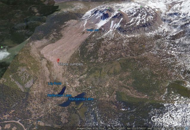
Google Earth imagery of the Chaos Jumbles rock avalanche deposits. Note the deposit of landslide III is almost unvegetated, but beneath this lie two other landslide deposits. Deposit I extends beyond Manzanita Lake.
.
The smallest and youngest deposit is easy to see – it extends from the large scar in the dome to just below te label that says Chaos Jumbles. Under this are two slightly earlier landslide deposits – these are clear in the map from Eppler et al. (1987) below:-
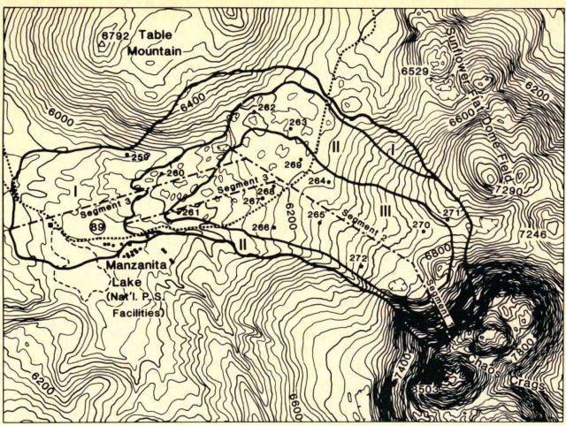
A map of the three Chaos Jumbles landslide deposits, from Eppler et al. (1987).
.
These are very large landslides – the runout of the largest extends about 4.5 km from the base of the dome, and the elevation change from the top of the scar to the toe of the landslide is about 650 m. The landslide cover an area of almost 7 km². The volume of the three landslides combined is thought to be about 120 million cubic metres, with the largest event (Deposit II) having a volume of about 50 – 70 million cubic metres.
A really interesting feature of this landslide deposit is the presence of very clear ridge structures in the landslide depsoits. These can be seen nicely in the Google Earth images collected when the sun was low:-
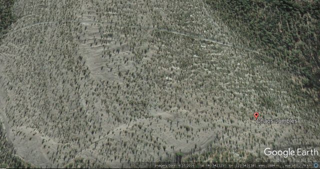
Google Earth imagery showing the clear ridge structures within the Chaos Jumbles landslide deposit.
.
These ridge and trough structures were taken by Eppler et al. (1987) to indicate that the landslide was undergoing compression and internal deformation in the later stages of its movement.
The cause of the collapses 350 years ago is not clear, but an earthquake is probably a strong candidate. Whilst the Chaos Jumbles landslides are of course not identical to those at Anak Krakatau, imaging what would happen if one of these landslides had entered the sea rather than running out across the desert plain serves to illustrate the processes in Indonesia. And note that there were three closely-spaced landslides at Chaos Jumbles; at Anak Krakatau one of the major worries is a further tsunami-generating collapse.
Reference
Eppler, D. B., Fink, J., & Fletcher, R. 1987. Rheologic properties and kinematics of emplacement of the Chaos Jumbles rockfall avalanche, Lassen Volcanic National Park, California. Journal of Geophysical Research: Solid Earth (1978–2012), 92(B5), 3623-3633.
 Dave Petley is the Vice-Chancellor of the University of Hull in the United Kingdom. His blog provides commentary and analysis of landslide events occurring worldwide, including the landslides themselves, latest research, and conferences and meetings.