
22 November 2018
Pre-failure analysis of the Fagraskogarfjall landslide
Posted by Dave Petley
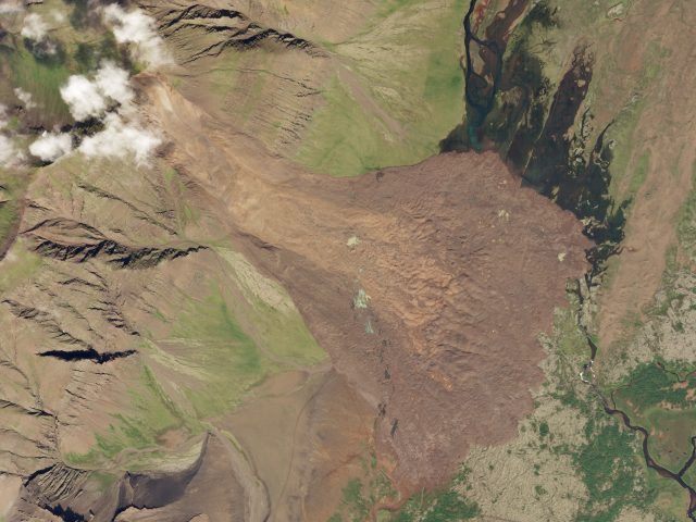
Planet Labs SkySat image of the Fagraskogarfjall landslide in Iceland. SkySat Image dated 19th July 2018, used with permission.
Pre-failure analysis of the Fagraskogarfjall landslide
Back in July I wrote about the Fagraskogarfjall landslide, a very large failure that occurred in western Iceland, inundating a large area of farmland. The volume of the failure is at the upper end of the scale – up to 20 million cubic metres – and it extended over 2.5 km. Fortunately this remote area of Iceland is sparsely inhabited, so there was no loss of life.
Large landslides such as this are generally predated by a long period of creep deformation – slow movement in which the failure develops progressively through time, often associated with the development of the final failure surface. This creates an opportunity to anticipate the location of major failures is creep deformation can be assessed. Whilst simple in concept, this is hard in practice. Measuring creep is difficult over large areas; we don’t really understand how different types of creep operate (do all slopes creep for example?); and can we differentiate between creep that might lead to catastrophic failure and creep that will not?
The advent of InSAR – the measurement of surface deformation using radar satellite data – potentially provides the answer to some of these questions. If it is possible to measure deformation over large areas on a regular basis then it may be possible to both understand background rates of creep and to identify those areas that might suffer a major failure. This is without doubt one of the most exciting areas of landslide science at the moment. I have noted previously that InSAR now provides the basis for measuring creep deformation with high levels of precision, and that wide area InSAR techniques are becoming available. Later this month Norway will launch a nationwide ground deformation map, a prospect that is immensely exciting.
NPA Satellite Mapping have looked at InSAR data for the period leading up to the failure of the Fagraskogarfjall landslide. Their results are available in a PDF article. In this case they have used Differential InSAR between July 2017 and July 2018. Their results, shown below, indicate that the parts of the slope were moving at up to 2 metres per year in the period up to the failure event:-
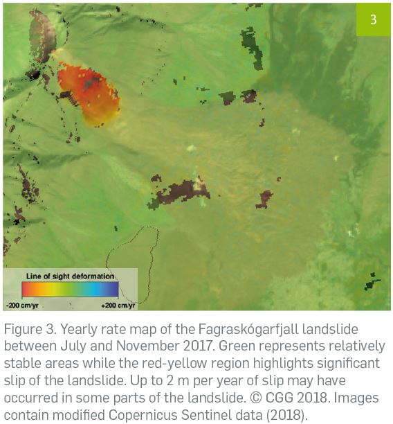
NPA Satellite Mapping analysis of pre-failure deformation of the Fagraskogarfjall landslide, including the original caption
.
There are several interesting aspects to this. First, of course, is that pre-failure creep of the Fagraskogarfjall landslide was detected. Second, the landslide showed differential movement, with the greatest accumulation of strain in the central portion of the landslide, in effect generating bulging that increased susceptibility to failure. And this, in this case the whole of the slope was moving (sometimes failure occurs in a portion of the slope, which then triggers failure through retrogression upslope or loading of lower slope portions). Thus, the InSAR data provides significant insight into deformation processes and the mechanisms of the slope failure.
Acknowledgement
Thanks to NPA Satellite Mapping for allowing me to highlight this example, and to Adam Thomas for bringing it to my attention. The analysis was undertaken using Copernicus Sentinel data.
Planet Team (2018). Planet Application Program Interface: In Space for Life on Earth. San Francisco, CA. https://api.planet.com
 Dave Petley is the Vice-Chancellor of the University of Hull in the United Kingdom. His blog provides commentary and analysis of landslide events occurring worldwide, including the landslides themselves, latest research, and conferences and meetings.