
1 October 2018
Lateral spreads from the 2018 Sulawesi earthquake
Posted by Dave Petley
Lateral spreads from the 2018 Sulawesi earthquake
NB: there is an update on these landslides on my post of 2nd October. These landslides are more complex than initially appeared to be the case).
The impact of the 2018 Sulawesi earthquake, which struck the isthmus of the Minahassa Peninsula in Indonesia on Friday 28th September 2018, is still being determined. The most serious impact appears to have been a significant series of tsunamis; initial Planet Labs imagery shows very widespread destruction to the coastal margins, once again. This will be a tsunami that will need to be studied in detail – the strike-slip mechanism of the earthquake is not one that would normally generate such a wave, although the 3D topography of the bay through which the fault runs may have allowed substantial changes in local volume, allowing the wave to form. However, the most likely explanation would seem to be one or more large submarine landslides, perhaps not surprising in an area with very sediment production in the tropical climate (which can generate large, unstable piles of sediment in the shallow marine environment). We will find out more in due course, and can only speculate at present.
In terms of terrestrial landslides, I would not expect this to be a particularly significant event, even though it has happened in tropical, hilly environment. Two factors should mitigate against very large numbers of landslides. First, the faulting mechanism seems to be associated with smaller numbers of landslides in general, based upon previous studies. And second, much of the surface trace of the fault is in the sea. Strike-slip faults generate landslides in very close proximity to the fault trace, and comparatively few at even intermediate distances. In this case, the amount of significant terrestrial topography close to the fault seems very limited. There will be landslides, but probably not in the huge numbers that we have seen elsewhere.
Two videos have emerged though that appear to show lateral spreads occurring during, or immediately after, the 2018 Sulawesi earthquake. These are remarkable, and truly terrifying, recordings. They have been posted on Twitter, and have drawn some criticism for being too graphic. I am not quite sure why this is the case, they do not seem to be unreasonable to me, but I note the concerns. The first is somewhat shaky (understandably), but remarkable for showing large structures in motion, including a transmission tower:-
.
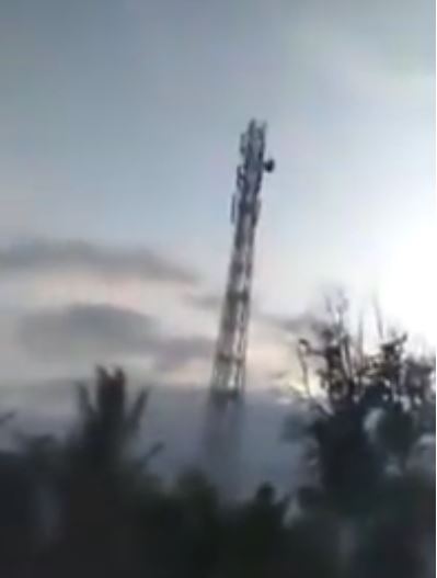
Lateral spreading from the 2018 Sulawesi earthquake. Still from a video posted on Youtube.
.
There is a version on Twitter, posted by @patton_cascadia, that corrects some of the rotations in the recording. It seems reasonably likely that this is a lateral spread type landslide, perhaps associated with a quick clay or dynamic liquefaction process. Unfortunately at present the location is unclear. The second is perhaps more clear in terms of process, and is equally dramatic:-
.
The absolute terror of those involved is obvious. As yet the location of the events, and indeed whether this is the same one or two different locations, is uncertain. This second video captures the aftermath of the earthquake well, and in particular the stunned disbelief of those involved in the 2018 Sulawesi earthquake.
NB: there is an update on these landslides on my post of 2nd October. These landslides are more complex than initially appeared to be the case).
 Dave Petley is the Vice-Chancellor of the University of Hull in the United Kingdom. His blog provides commentary and analysis of landslide events occurring worldwide, including the landslides themselves, latest research, and conferences and meetings.
We had an extensive discussion on Twitter about the first video. I think that it is unlikely that the radio (probably cellular) tower is moving. It seems much more likely that the building that the videographer is on is moving past the tower.