
3 April 2018
Landslides triggered by the 14 November 2016 Mw 7.8 Kaikoura Earthquake, New Zealand
Posted by Dave Petley
Landslides triggered by the 14 November 2016 Mw 7.8 Kaikoura Earthquake, New Zealand
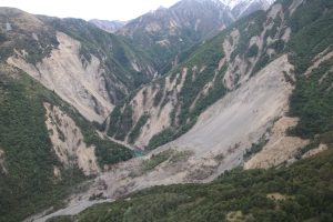
Examples of landslides triggered by the Mw 7.8 Kaikoura Earthquake
The 14 November 2016 Mw 7.8 Kaikoura Earthquake in New Zealand was one of the most significant seismic events in terms of landslide triggering in recent years. I have written about this earthquake, and its landslides, on a number of occasions. In the months since the earthquake a large team has been involved in constructing an inventory of landslides from this event, and in analysing it. A first description of this inventory, and analysis of the landslides associated with the earthquake has now been published (Massey et al. 2018) in the Bulletin of the Seismological Society of America. I have to declare an interest – I am a co-author on this paper.
Massey et al. (2018) demonstrate that the earthquake generated over 10,000 mappable landslides (the inventory described was under development when we wrote the paper, so this total may well increase) over an area of about 10,000 km². Neither the number of landslides nor the area over which they occurred are surprisingly high; indeed if anything the number is low when compared with other events in New Zealand and with global landslide inventories. The largest landslide, on the Hapuku River, had a volume of about 20 million m³ and ran out over a distance of about 2.7 km.
The map below shows the distribution of the landslides triggered by the Mw 7.8 Kaikoura Earthquake, as mapped by Massey et al. (2018). The fault ruptures that generated the earthquake are also shown; note that this was a highly complex seismic event that involved the near-simultaneous rupture of multiple faults and fault segments. The resultant landslide distribution is also highly complex.
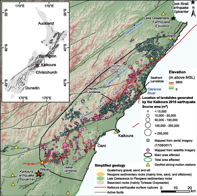
The distribution of landslides from the Mw 7.8 Kaikoura Earthquake in 2016. Figure from Massey et al. (2018)
.
I think there are two really interesting aspects of the landslides mapped by Massey et al. (2018). First, the density of landslides triggered by the Mw 7.8 Kaikoura Earthquake was highest close to the fault – indeed our model of the landslide distribution suggests that the distance to the fault rupture was a better predictor of landslides than either the modeled peak ground acceleration or peak ground velocity. It is not clear as to whether this means that the distance function is capturing a key parameter in cosieismic landslide initiation (if so, what is it?) or that the models of peak ground acceleration and peak ground velocity are not capturing reality well. Indeed Massey et al. (2018) found that the landslide density within 200 m of a mapped surface fault rupture was, on average, three times that of locations at a distance of 2500 m.
And second, Massey et al. (2018) found that the point density of landslides for the coastal slopes was much higher than that for inland slopes in similar materials. This may well indicate that more active erosion has meant that the coastal slopes are more out of equilibrium with the environment when compared with the inland slopes.
Reference
C. Massey, D. Townsend, E. Rathje, K. E. Allstadt, B. Lukovic, Y. Kaneko, B. Bradley, J. Wartman, R. W. Jibson, D. N. Petley, N. Horspool, I. Hamling, J. Carey, S. Cox, J. Davidson, S. Dellow, J. W. Godt, C. Holden, K. Jones, A. Kaiser, M. Little, B. Lyndsell, S. McColl, R. Morgenstern, F. K. Rengers, D. Rhoades, B. Rosser, D. Strong, C. Singeisen, M. Villeneuve. 2018. Landslides Triggered by the 14 November 2016 Mw 7.8 Kaikoura Earthquake, New Zealand. Bulletin of the Seismological Society of America doi: https://doi.org/10.1785/0120170305
 Dave Petley is the Vice-Chancellor of the University of Hull in the United Kingdom. His blog provides commentary and analysis of landslide events occurring worldwide, including the landslides themselves, latest research, and conferences and meetings.