
8 February 2018
Predicting failure using ground-based radar and INSAR
Posted by Dave Petley
Predicting failure using ground-based radar and INSAR
A new paper just published in the journal Engineering Geology (Carla et al. 2018) explores the use of ground-based radar and INSAR to predict landslide failure. The case study is based on events in an unspecified copper mine in November 2016, when an unexpected failure with a volume of 410,000 m³ occurred in the excavated and benched walls of the mine. The landslide was large – about 400 m in length and up to 300 m in width. Clearly such an event represents a substantial risk to mine operations. The slope was being monitored with ground-based radar, but the development of the failure was not detected. This is of course quite disconcerting.
Carla et al. (2018) have investigated this failure in detail. They found that, as a result of line-of-sight issues, the ground-based radar could detect deformation in only two benches, with the rest of the developing landslide being out of view of the system. Most of the landslide comprised failure of a natural slope above the mine. To understand the development of the failure, they examined INSAR data over the months leading up to the landslide, based upon Sentinel-1 data. The results are fascinating. The developing landslide is clearly evident on the INSAR data, and the acceleration of the slope to failure is clearly evident, as the graph below from the paper shows:-
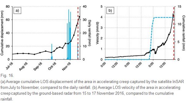
Displacement data for ground-based radar and INSAR measurements, from Carla et al. (2018)
.
The authors suggest that monitoring using INSAR would have allowed the landslide to be detected, and in turn this would have allowed the ground-based radar to be used to detect the deformation in the benches within line of sight as the landslide accelerated to failure on the day of the collapse (the graph on the right). Note that the period of accelerating creep started about two months before the collapse, so plenty of warning of impending problems would have been available. The authors then used the inverse velocity approach (sometimes called the Saito technique) to determine whether the time of failure could have been predicted. The data below speaks for itself:-
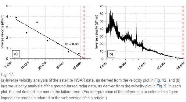
Inverse velocity data for the collapse of the slope in the unspecified copper mine from Carla et al. (2018)
.
The paper demonstrates beautifully both the incredible opportunities that INSAR derived from Sentinel provides for the monitoring of slope deformation, and the ways in which this data can be combined with ground-based radar to provide high quality warning systems. It is an excellent piece of work.
Reference
Tommaso Carlà, Paolo Farina, Emanuele Intrieri, Hakki Ketizmen and Nicola Casagli 2018. Integration of ground-based radar and satellite InSAR data for the analysis of an unexpected slope failure in an open-pit mine, Engineering Geology, 235, 39-52. https://doi.org/10.1016/j.enggeo.2018.01.02
 Dave Petley is the Vice-Chancellor of the University of Hull in the United Kingdom. His blog provides commentary and analysis of landslide events occurring worldwide, including the landslides themselves, latest research, and conferences and meetings.
A very nice effort —
#rattlesnakeridge, #glacierbay, #Mudcreek, #PaulsSlide (#OSOslide) etc ….
In the Civil Works sector … CAN we deliver safety awareness, opportunity for better decisions, and supporting data where it is not WANTED, perhaps even FEARED……