
26 June 2017
Xinmo landslide: an update
Posted by Dave Petley
Xinmo landslide: an update
Whilst the search for survivors from the Xinmo landslide in Sichuan Province, China continues, the reality is that there can now be almost no prospect of anyone else being found alive. This image, from Xinhua, provides an indication of the scale of the problem facing the recovery teams:
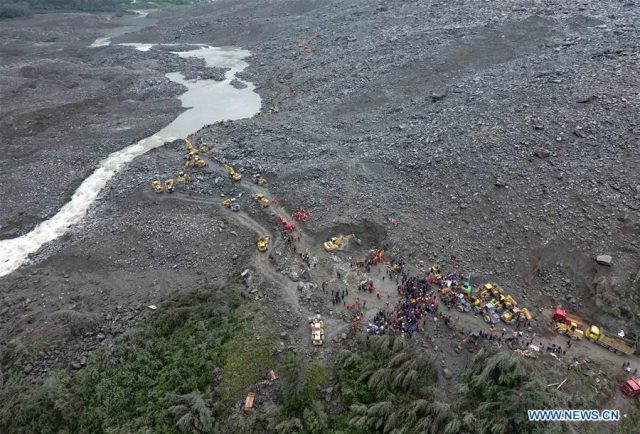
Recovery operations from the Xinmo landslide in China, showing the scale of the challenge. Image via Xinhua
.
Meanwhile, the Herald has published this image (via AP Photo/Ng Han Guan) that provides a sense of the likely mechanism of this 8 million cubic metre landslide:-
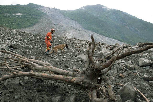
The Xinmo landslide in China, showing the slip surface. Image via Herald Net (AP / Ng Han Guan )
.
Above and behind the rescuer the slide plane is clearly visible – it appears to be an approximately planar rock surface, suggesting that this landslide was a translational slide on an existing defect. In the lower part of the hillside it has incorporated a large volume of weathered rick and colluvium.
Meanwhile a kind reader has pointed out that the the history of large landslides, and of landslide dams, is described in a good Masters thesis – Song (2015) – available on the University of Waterloo website. This gives an estimated location for the 1933 Diexi earthquake, which is within a few kilometres of the Xinmo landslide, as the Google Earth image below shows:-
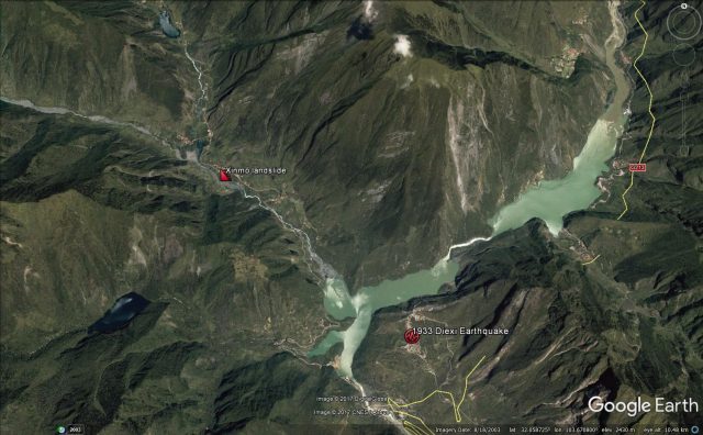
Google Earth image showing the location of the Xinmo landslide in relation to the 1933 Diexi Earthquake
.
The lakes visible on this image were formed by landslides that blocked the valley during the Diexi earthquake. As I noted yesterday, the site of the Xinmo landslide appears to be an old landslide scar, one of several on that ridge:-
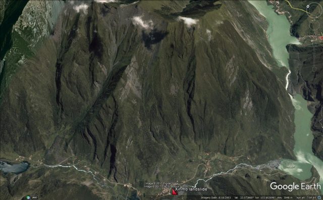
Google Earth image of the Xinmo landslide site. Note the landslide scars extending to the ridge
.
These landslide scars extend right up to the ridge crest, which is a common feature of earthquake-triggered landslides. A good hypothesis therefore might be that the Xinmo landslide was a slide in an unfailed portion of a landslide triggered in the 1933 earthquake. Interesting, Song (2015) reports that in the area around the town of Diexi:
Orientation of these rock layers [is] mainly 170°in dip direction and 30°in dip angle.
If this is true at Xinmo as well, then this would explain the defect seen in the Herald Net image above. I have no doubt that the mechanisms of this landslide will be investigated by our colleagues in China, and will be published in due course.
Reference
Song Ling (2015). Landslide damming in Western Sichuan Province, China, with special reference to the 1786 Dadu River and 1933 Diexi events. UWSpace. http://hdl.handle.net/10012/9496
 Dave Petley is the Vice-Chancellor of the University of Hull in the United Kingdom. His blog provides commentary and analysis of landslide events occurring worldwide, including the landslides themselves, latest research, and conferences and meetings.