
15 February 2016
Sumner rockfalls – videos from the M=5.7 earthquake near Christchurch yesterday
Posted by Dave Petley
Sumner rockfalls
The M=5.7 earthquake in Christchurch, New Zealand yesterday triggered a new set of rockfalls in the Sumner area to the south of the city. These Sumner rockfalls occurred on the same cliffs that were subjected to repeated collapses in the 2011-12 Christchurch earthquake sequence. I have posted images of these rockfalls previously, and there has always been concern that there would be further collapses on the cliffs to the south of the city as a result of further aftershocks or intense rainfall.
The earthquake is well-described in a press release put out by Geonet:
A magnitude 5.7 earthquake has occurred at 1:13 pm New Zealand time, 15 km east of Christchurch approximately 15 km deep. So far we have received 2974 felt reports from Hawke’s Bay to Invercargill as at 6:30 pm. The highest level of impact from our felt reports so far has been MMI 8 in central and Christchurch. This is also shown in the coloured Shake Map … which models shaking intensity in Modified Mercalli Intensity.
This is the Shake Map that Geonet have posted. Expect this to be updated in the days ahead, but it shows that parts of the Christchurch area were subjected to quite intense shaking:
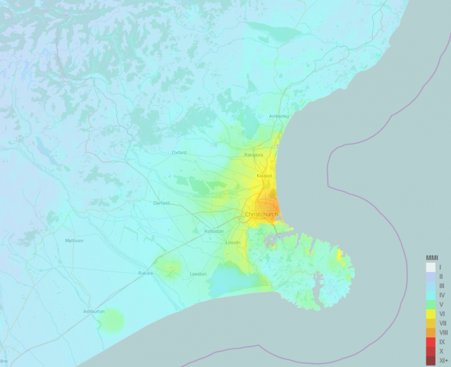
Geonet shakemap from the M=5.7 earthquake off the cost of Christchurch on Sunday
.
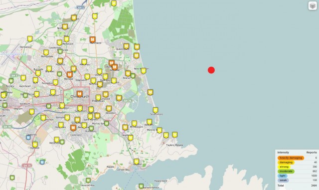
Geonet map showing felt reports in the Christchurch area
.
As usual the felt reports correlate well with the shaking intensity map. The Sumner area was subjected to strong shaking, triggering the Sumner rockfalls. The timing of the earthquake was perfect for the collection of videos – it occurred on a Sunday afternoon in the summer vacation on a sunny day near to the beach. In consequence several people captured videos and photos of the Sumner rockfalls. The best photo is this one I think, taken by RNZ / Sally Murphy, shows the rockfalls in action. Note that the images shows multiple streams of shallow rockslides and rockfalls, all generating large amounts of dust:
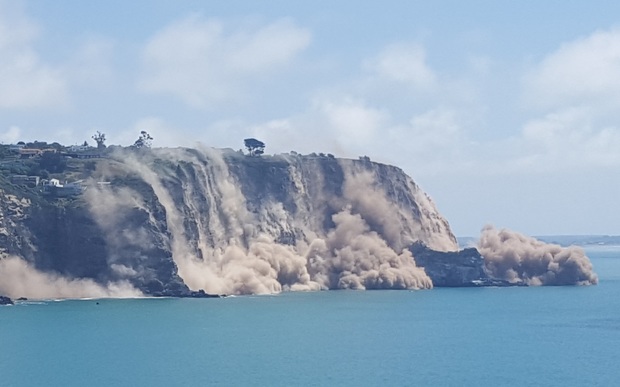
Sumner rockfalls by RNZ/ Sally Murphy
.
There is a host of videos on Youtube showing the immediate aftermath of the rockfalls. Three of the best examples are as follows:
.
.
.
Amazingly there is also drone footage available already showing the sites of these rockfalls:
.
The volume of material released in these Sumner rockfalls is not huge, but there are many sites on the cliffs. In the next few months there will be a new burst of aftershocks, so expect more rockfalls, albeit on a lesser scale.
 Dave Petley is the Vice-Chancellor of the University of Hull in the United Kingdom. His blog provides commentary and analysis of landslide events occurring worldwide, including the landslides themselves, latest research, and conferences and meetings.