
2 February 2016
Landslides in Chile Part 5: Water waves triggered by landslides and the Mentirosa Island Landslide complex
Posted by Dave Petley
Landslide in Chile 5: the Mentirosa Island landslide complex
By Dr Melanie Froude (@Froudo_baggins), University of East Anglia
Cymophobia, the fear of waves and wave-like motions, is capitalised on by the 2015 Norwegian film, The Wave (originally titled Bølgen). Opening sequences of the trailer remind us of the devastating Norwegian Tafjord slide of 1934. Here an estimated 3 million m3 of rock slid into the fjord, generating a <60 m displacement wave of water that travelled 4.5 km up-fjord; inundating shoreline communities with c.15 vertical metres of water (Baathen et al., 2004). Distinction is made between the term displacement wave and tsunami, the former generated by subaerial landslides impacting into water bodies, and the latter caused by the movement of submarine landslides (Hermanns et al., 2014). With all the merits of a blockbuster disaster movie, The Wave presents a worst case scenario, fully CGI-realised, depiction of the catastrophic failure of the Åknes rockslide (also in Norway) and subsequent displacement wave. It is no surprise that this landslide has gained attention from filmmakers, having a colossal estimated volume of 30-40 million m3, and the potential to deliver a 40 m wall of water to the villages of Hellesylt and Geiranger (Oppikofer et al., 2009). The Åknes rockslide is one of the most extensively monitored landslides in the world, and alarm thresholds with public alert levels have been established based on displacement, velocity and acceleration of the slope surface and subsurface (via boreholes).
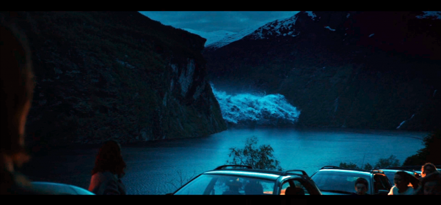
Frame from The Wave. Tsunami rounds the bend of the fjord generating panic for evacuating residents of Geiranger. Film due for US full-release on 4th March 2016, IMDB
.
Water waves triggered by landslides, either originating from an exposed slope (e.g. valley wall) or occurring under water (submarine), pose a danger to communities living around confined water bodies such as fjords, coastal bays, rivers, lakes and reservoirs. Large masses of rock are effective at generating waves when impacting water at high speeds. Waves are then guided by local narrow topography, which may amplify wave height and reflect waves sending them in an alternative direction; leading wave activity to last for hours and extensive damage to shorelines from run-up. Several landslides that triggered waves of different magnitudes have been reported in this blog: (1) Porcupine Bay, Washington State, (2) Nord-Statland, Norway, (3) Vaiont, Italy, (4) Daning River, China, (5) Sokjosen, Norway and (6) Lituya Bay, Alaska. The largest wave occurred in Lituya Bay and had a maximum run-up height (vertically up the valley wall) of 530 metres. Sonny and Howard Ulrich provide an eyewitness account of the event for the BBC Mega Tsunami documentary, available here.
Differences in source landslide trigger, size, material and mechanism, as well as local variations in topography, challenge scientists who use numerical computer models to forecast the formation and propagation of water waves to inform hazard assessment. There is much research published in this field for sites in the fjords of Norway, which is unsurprising as Oppikofer et al. (2009) point out, historical and geological evidence indicates one catastrophic rockslide event has occurred approximately every 100 years in the Storfjord in Western Norway alone. Shifting hemispheres, and focusing on the fjords of Chilean Patagonia, I was surprised that water waves triggered by landslides were not more commonly reported given the extensive network of fjords containing steep slopes of often fractured bedrock and volcanic surficial deposits. Landslides may be occurring out of sight of coastal population centres, historic events may not be documented due to the relatively recent mass settlement of the region (following the 1902 Cordillera of the Andes Boundary Case), or the physical conditions for occurrence of a landslide of sufficient magnitude and mechanism to locally generate a displacement wave or tsunami, may not be often realised. With the exception of the landslides triggered by the Aysén (Aisén) earthquake on 21 April 2007, and a local testimony from Puerto Aysén regarding landslides and waves generated by an earthquake in November 1927 (Naranjo et al., 2009), very little is published on landslide-induced tsunamis/displacement waves in Chilean Patagonia. Of course, there is also the possibility that events and historical studies reported in Spanish have not been identified, and I welcome contributions from readers highlighting these.
The Mentirosa Island Landslide complex, Chilean Patagonia
My last blog post discussed the Punta Cola rock avalanche, providing some detail on Aysén (Aisén) fjord and the 2007 earthquake on the Liquiñe-Ofqui Fault zone (LOFZ). The Mentirosa Island landslide complex is composed of four soil-rock slides from the north-eastern slopes of Aysén fjord, with a total estimated volume of 8 million m3 (Sepúlveda & Serey, 2009). It is located less than 5 km from the earthquake epicentre. Research on this landslide is ongoing by Sergio Sepúlveda and others at the University of Chile; observations here are preliminary from fieldwork in January 2016.
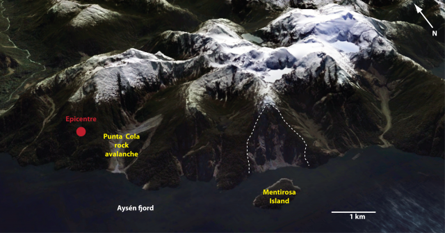
Location of the Mentirosa Island landslide complex, to the north of Mentirosa Island (shown within the dashed white line). The location of the 2007 Aysén earthquake epicentre is shown by the red dot.
.
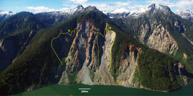
Four soil-rock slides make up the Mentirosa Island landslide complex. The source area for each is shown, and each scar is labelled (A to D). (Note there is a slight reflection in the photograph obscuring the lower section of D).
.
All four soil-rock slides failed from near the top of the hillside, suggesting the topographic amplification of seismic waves. Scar A appears to have derived from two smaller rock wedge failures, which have coalesced to form a debris fan at the slope base. Inspection of scar of B indicates the rock mass failed as a simple joint-controlled wedge, sliding downslope and disintegrating rapidly. The scar contains significant amounts of loose debris, stored on lower gradient rock ledges, showing the persistence of rockfall activity. Scar C has a slightly more complex geometry suggesting failure derived from two main wedges of rock; the translational movement is believed to be similar to B. The steeper geometry of the scar means debris is transported rapidly from rockslope to debris fan downslope. Large masses of highly fractured rock are exposed within the scar, highlighting the potential of future block failure. Landslide D is likely to have failed as a series of blocks; mineral veins are evident within the scar and the rock is highly fractured.
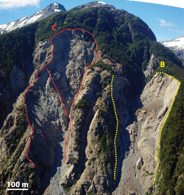
Mentirosa Island landslide scars B and C. Approximate boundaries of rock mass failure shown by dashed line. Red dashed line dividing the total scar area on C shows the possible division of the scar into two rock wedges.
.
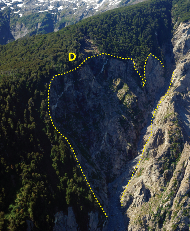
Mentirosa Island landslide scar D.
.
After detachment and disintegration it is possible that material from each soil-rock slide travelled downslope as a rock avalanche/ debris flow (depending on slope saturation) before impacting the fjord water surface. Fan deposits at the base of slide B show some inverse grading and larger boulders (~0.5 m) are located close to the surface. Material is predominantly angular gravels and boulders, and there is evidence for post-2007 rockfall and sediment-water flows (incision and cross-cutting channels) on the surface of the debris fan.
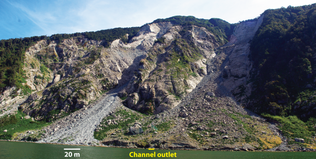
Looking up the debris fans of slide B (right) and slide C (left). Incision of channel into fan exposed vertical profile of landslide deposit (below).
.
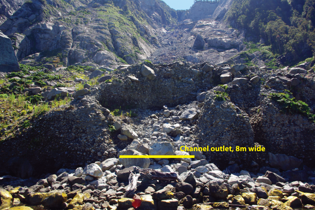
Looking up the debris fan of slide B
.
The impact of two of the landslides into the fjord were photographed by F. Olivera from a research vessel on the water at the time. These excellent photographs are published in Narangio et al.’s (2009) paper, which is free to view. Interpretation of the photographs suggests one of the landslides to the east of the Mentirosa Island complex impacted the water first (likely landslide B). The impact generated a displacement wave, which ran up the eastern coast of the Mentirosa Island. A second displacement wave generated by slide C impacted the island within 20 seconds of the first. The waves removed soil and vegetation from the lower <65 m of the eastern slopes of Mentirosa Island, and propagated into the fjord, increasing in amplitude in shallower waters, resulting in runouts of several hundreds of meters on coastal areas around Puerto Aysén. Landslides which triggered displacement waves and tsunamis were within 5 km of the epicentre of the 2007 Aysén earthquake. Seismic activity associated with the LOFZ poses a significant hazard to coastal communities in the Aysén region of Chilean Patagonia. The landslide and tsunami hazard for other towns such as Hornopirén, is being assessed using landslide inventories from the 2007 event and laboratory testing of slope materials, by members of the Newton Fund/NERC project on earthquake-induced landslides.
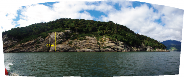
Mentirosa Island. Slope stripped of soil and vegetation from wave impact in 2007 still clearly delineated in 2016.
.
References
Baathan, A., Blikra, L.H., Berg, S.S. & Karlsen, F. (2004) Rock-slope failures in Norway; type, geometry, deformation mechanisms and stability, Norwegian Journal of Geology, 84 (1), pp.67-88
Hermanns, R.L., Oppikofer, T. Roberts, N.J. & Sandøy, G. (2014) Catalogue of Historical Displacement Waves and Landslide-Triggered Tsunamis in Norway (Chapter 13), in: Lollino, G., Manconi, A., Locat, J., Huang, Y., Artigas, M.C. (eds.) Engineering geology for Society and Territory- Volume 4: Marine and Coastal Processes, Springer, 235 pages
Naranjo, J.A., Arenas, M., Clavero, J., Muñoz, O. (2009) Mass movement-induced tsunamis: main effects during the Patagonian Fjordland seismic crisis in Aisén (45°25’S), Chile, Andean Geology, 36 (1), pp. 137-145
Oppikofer, T., Jaboyedoff, M., Blikra, L., Derron, M.-H., Metzger, R. (2009) Characterization and monitoring of the Åknes rockslide using terrestrial laser scanning, Natural Hazards and Earth System Sciences, 9, pp.1003-1019
Sepúlveda, S.A. and Serey, A. (2009) Tsunami-genic, earthquake-triggered rock slope failures during the April 21, 2007, Aisén earthquake, southern Chile (45.5° S). Andean Geology 36: 131-136. Doi: 10.4067/S0718-71062009000100010.
 Dave Petley is the Vice-Chancellor of the University of Hull in the United Kingdom. His blog provides commentary and analysis of landslide events occurring worldwide, including the landslides themselves, latest research, and conferences and meetings.
Mentirosa Island Landslide Complex: Not just waves generated by impact… also tsunamis…
Two papers (links below) make an excellent point about the role of basal-plain deformation on tsunami generation in Aysen fjord. Using bathymetry, seismic-profiles and sediment cores, the papers present analysis on the morphology and sedimentology of structures on the base of the fjord created by the weight and impact of debris originating from on-shore mass movements. Resulting in vertical seafloor offsets of up to 20 m, the authors highlight the importance of this submarine process in generating tsunamis in the fjord. While the photographs from the research vessel near Mentirosa Island at the time of failure (see Naranjo et al., 2009), show the generation of a water wave from the impact of landslide debris on the fjord water surface, surveys analysed within Daele’s papers suggest submarine processes are thought to be also be at play.
Daele et al. 2013
http://www.sciencedirect.com/science/article/pii/S002532271300011X
Daele et al. 2014
http://onlinelibrary.wiley.com/doi/10.1111/sed.12070/abstract