
27 January 2016
Landslides in Chile 4: The Punta Cola rock avalanche in Aysén Fjord
Posted by Dave Petley
The Punta Cola rock avalanche in Aysén Fjord, Chile
By Dr Melanie Froude (@Froudo_baggins), University of East Anglia
Aysén (Aisén) fjord is located at 45.26° latitude in Zona Austral, Chile (Chilean Patagonia). In common with other mountainous regions in Chile, the landscape is tectonically controlled, however in contrast to valleys such as the Maipo valley in the Central Andes, the coastline of south Chile is dominated by fjords. The fjords were formed during deglaciation, when rising sea levels inundated glacier-carved valleys as the continental ice cap retreated towards the end of the Pleistocene (about 15,000 years ago). Erosion by the ice has left deep fjords (Aysén fjord has a depth greater than 350 m), steep bedrock slopes and ice covered mountain peaks, with lower level hummocky terrain attributed to glacial moraines and landslides. Topography is overlain with shallow volcanic soils and temperate dense virgin forest, which thrives in the wet climate; Puerto Aysén has an average annual rainfall of 2,600 mm although this may reach 4,000 mm in the fjord.
Nestled within a steep drainage on the north side of Aysén fjord is the Punta Cola rock avalanche. Triggered by the Mw 6.2 Aysén earthquake on 21 April 2007 on the Liquiñe-Ofqui Fault zone (LOFZ), this was the largest of a total 538 mapped earthquake-triggered landslides ( Sepúlveda and Serey 2009; Sepúlveda et al., 2010), with an estimated total volume of 22.4 M m³ (Oppikofer et al., 2012).
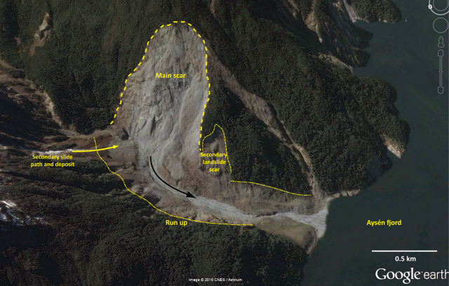
The Punta Cola rock avalanche and avalanche via Google Earth (Image date 10/11/2013)
Without a site visit, the magnitude of this landslide is difficult to comprehend in real terms; the panorama and insert below, illustrate quite how small ‘we’ are and present an intimidating reminder of the extent of damage caused when large landslides occur in densely populated regions.
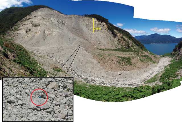
The main scar of the Punta Cola rock avalanche and the valley infill of rock avalanche deposit viewed from the north-west valley slopes, looking north east. Insert: shows a researcher sat on-top of a ~4m boulder for scale
The Punta Cola rock avalanche deposit is composed of a very large event and seven smaller secondary landslides. The main rockslide was composed of a <135 m thick block of North Patagonian Batholith, which broke into small fragments, sliding into the valley and running up the opposite slope by up to 180 m (Hermanns et al., 2014). The slide transformed into a highly mobile rock avalanche travelling down valley for 1.5 km into Aysén fjord, generating a displacement wave (akin to a tsunami). The rock avalanche accelerated as it descended into the fjord causing a large section of the pre-existing shoreline sediment ramp to collapse. Bathymetric data obtained in March 2013 (see Hermanns et al., 2014) show deformation across the full 3.5 km fjord width, interpreted as the impact of the avalanche as it slammed into sediments on the fjord floor, generating up to 10 m of vertical erosion and deformation structures, including concentric compressional ridges and large (< 70 m) sediment fragments.
Oppikofer et al. (2012) used terrestrial LiDAR to create a high resolution topographic model (DEM) of the landslide scar and deposit, from which an estimate of landslide volume was obtained, and geomorphological units were mapped. They hypothesised that failure was initiated at compartment A (see below), triggered by the 2007 earthquake, which led to the sequential failure of compartments B and C shortly after the main event. Material from compartments A and B was thought to have contributed to the rock avalanche, while compartment C was likely to have deposited at the base of the slope, possibly temporarily damming the river valley.
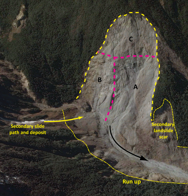
Compartments A, B and C within the Punta Cola rock avalanche scar. Redrawn from Oppikofer et al. (2012) interpretation onto a Google Earth basemap.
The evolution of the Punta Cola landslide scar and deposit are being monitored by a team from NGU, headed by Reginald Hermanns, in collaboration with the University of Chile. The team repeated the terrestrial LiDAR survey earlier this month, and will be comparing the new data with their previous survey (from 2010) to identify recent landslide activity and measure changes in the morphology of the debris fan.
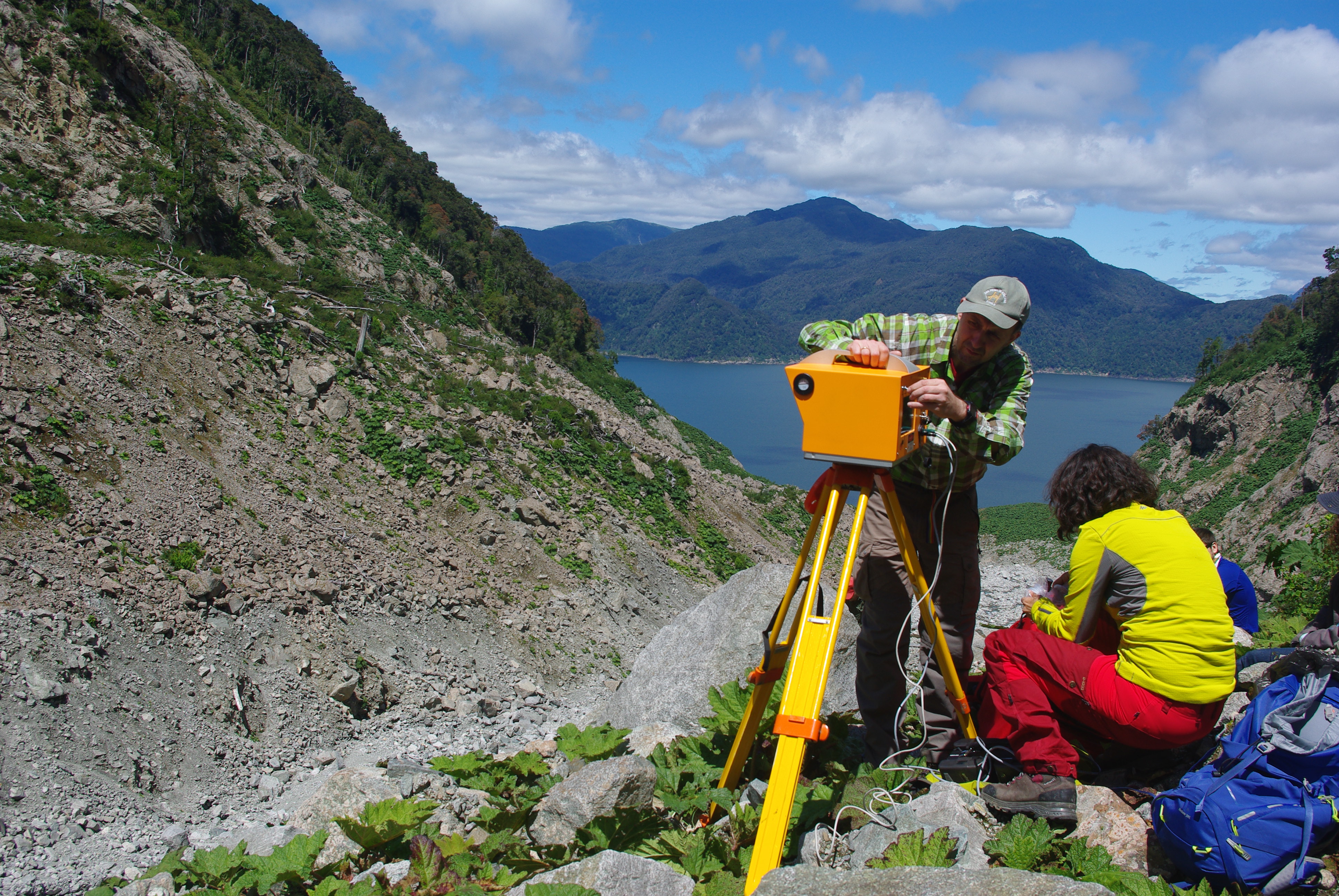
The NGU team setting up the Optech LiDAR from the first scan point
Large sections of slope eroded by the 2007 rock avalanche run-out are now revegetated, primarily by Gunnera Tinctoria (Chilean rhubarb), which seems to be the main colonizing plant on disturbed areas around the fjord. Debris slides and rockfall persist in the valley, primarily from unvegetated sections of loose boulders near the valley floor and from within the main and secondary bedrock scars, which are composed of highly fractured rock. Comparison to photographs in the Oppikofer et al. (2012) paper show that over 10 m of rock avalanche deposit has been remobilised, highlighting the transport capacity of water-sediment flows over just five years, in sediment-charged mountainous environments.
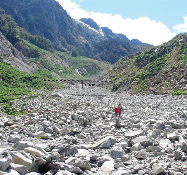
Looking upstream towards the base of the Punta Cola rock avalanche ~1 km from Aysén fjord. Over 10 m of material has been eroded from the 2007 rock avalanche and secondary landslide deposits by sediment-water flows between January 2010- January 2016.
The displacement wave from this landslide and a second wave from the Metirosa landslide (see Sepúlveda et al., 2010), caused significant damage to salmon farms in the fjord and to infrastructure on the shoreline (with run-ups of several tens of metres). Ten people were killed by these waves and debris flows associated with the earthquake. Operations in the fjord including fishing and tourism are of great economic value to the local community. Critically, the April 21 2007 Aysén earthquake is the first seismic event to be directly attributed to the LOFZ. Ongoing research is focused on the seismic and landslide hazard posed by future earthquakes on the LOFZ.
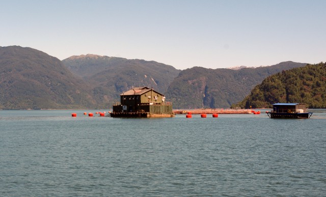
Salmon farming in Aysén fjord
References
Hermmans, R.L., et al., (2014) Ch 14: Earthquake-triggered subaerial landslides that caused large scale fjord sediment deformation: combined subaerial and submarine studies of the 2007 Aysén fjord event, Chile. In: Lollino, G. et al. (eds.) Engineering Geology for Society and Territory – Volume 4. Doi: 10.1007/978-3-310-08660-6_14, Springer International Publishing, Switzerland
Oppikofer, T., Hermanns, R.L., Redfield, T., Sepúlveda, S.A., Duhart, P., Bascuñan, I. (2012) Morphologic description of the Punta Cola rock avalanche and associated minor rockslides caused by the 21 April 2007 Aysén earthquake (Patagonia, southern Chile). Revista Asociación Geológica Argentina 69:339–353.
Sepúlveda, S.A. and Serey, A. (2009) Tsunami-genic, earthquake-triggered rock slope failures during the April 21, 2007, Aisén earthquake, southern Chile (45.5° S). Andean Geology 36: 131-136. Doi: 10.4067/S0718-71062009000100010.
Sepúlveda, S.A., Serey, A., Lara, M., Pavez, A. and Rebolledo, S. (2010) Landslides induced by the April 2007 Aysén fjord earthquake, Chilean Patagonia. Landslides 7: 483-492. Doi: 10.1007/s10346-010-0203-2.
 Dave Petley is the Vice-Chancellor of the University of Hull in the United Kingdom. His blog provides commentary and analysis of landslide events occurring worldwide, including the landslides themselves, latest research, and conferences and meetings.