
9 September 2015
West Salt Creek Landslide: Colorado Geological Survey report
Posted by Dave Petley
West Salt Creek Landslide report
The Colorado Geological Survey has produced a report on the catastrophic West Salt Creek landslide, which killed three men on 25th May 2014. The report (White et al. 2015), which is available for download from the Colorado Geological Survey website, is an excellent piece of work. It provides a high level of insight into the conditions that led to the landslide, its behaviour during movement (which was very complex) and the long term hazards that the site now presents. It also provides some beautiful and enlightening images of the landslide, such as this one:
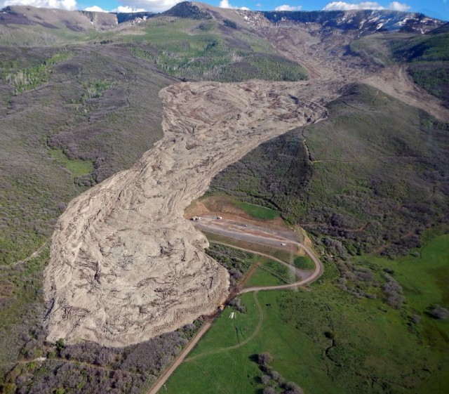
West Salt Creek landslide from White et al. (2015)
.
There is so much in this report that I cannot do it justice here. I particularly like the forensic approach that has been taken to understanding the morphology and to draw inferences into the mechanisms of motion.
The landslide was initiated by a rotational failure in a large block, as seen in this image from the report:
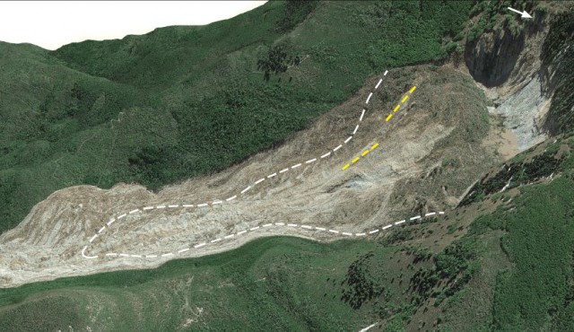
West Salt Creek landslide from White et al. (2015)
.
The white dashed line in the image above shows the location of a prehistoric landslide identified in the imagery. A small part of the rotational block detached and fragmented, turning into a high energy debris/rock avalanche event. The yellow dashed lines show the points of detachment. This high energy flow is interesting and intriguing, extending the landslide to a total crown to toe distance of about 4.5 km. The maximum velocity of this component of the landslide is estimated to have been between 18 m/sec and a peak at about 40 m/sec. This is perhaps surprisingly high, but the methods used are credible. The outcome is that the landslide showed a high level of mobility in terms of runout distance given its volume and elevation change, as shown in this plot:-
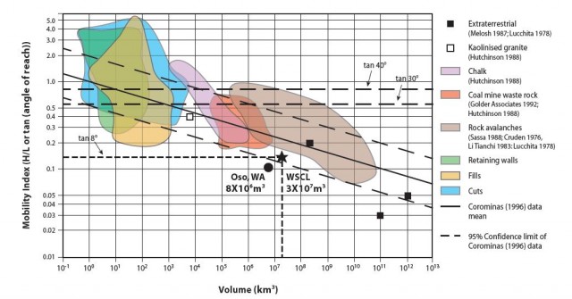
West Salt Creek landslide mobility from White et al. (2015)
.
But perhaps the most surprising aspect of this behaviour is that the landslide appears to have been a comparatively dry flow event. White et al. (2015) note that:
Overall the rock avalanche was a markedly dry deposit; during the field investigation, no water or mud was seen seeping or fanning out from the steeply sided edge of the avalanche toe.
White et al. (2015) identify three phases of movement of the West Salt Creek landslide, creating a very complex and in some ways very beautiful deposit, as this image shows:
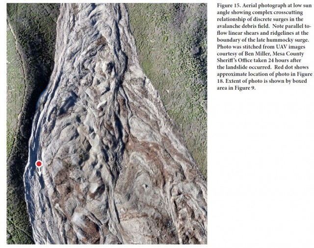
West Salt Creek landslide deposit, from White et al. (2015)
.
Note the evidence for the late stage surge movement of the landslide on the left (as shown above) side of the deposit. The red dot is on the margin of this flow. So, White et al. (2015)) conclude that after the initial rotational failure, the West Salt Creek consisted of a series of dry rock avalanche surges that achieved high velocity and a long runout. This will have implications for landslide hazard management in this landscape.
Reference
White, J.L., Morgan, M.L. and Berry, K.A. 2015. The West Salt Creek Landslide: A Catastrophic Rockslide and Rock/Debris Avalanche in Mesa County. Colorado Colorado Geological Survey, 45 pp.
 Dave Petley is the Vice-Chancellor of the University of Hull in the United Kingdom. His blog provides commentary and analysis of landslide events occurring worldwide, including the landslides themselves, latest research, and conferences and meetings.
I wondered about the apparent dryness of the deposit and such a long runout. I have ordered the CGS report and await its arrival!
PS: The amount of slide-related topo in this part of Colorado is astounding. On a different note, there is a long, broad valley 2-1/2 miles east of this slide that has a smooth convex floor – creeks running down either side. Any thoughts out there on its cause?
Surveys are very important, whether it is about water surveys or geological surveys. They give us information about the situation nicely and we can be ready for the consequences that might happen. Thanks for providing this information here. The graphs and pictures helped a lot to understand.