
30 April 2014
The Seti River landslide disaster in Nepal: two years on
Posted by Dave Petley
The Seti River landslide
Almost two years ago, on 5th May 2012, a catastrophic debris flow swept down the Seti River in Nepal, killing over 70 people. Working with various colleagues and friends through this blog, we quickly reconstructed the events that caused the debris flow; the key aspect being that the initiation was a large rock avalanche on the flank of the huge Annapurna IV mountain.
Since the landslide the reconstruction of events that we compiled has proven to be largely correct. It is clear that the starting point of the sequence of events was a massive rock slope failure; that this turned into a rock avalanche that swept across the high altitude plateau; that the debris avalanche entered the gorge system in the Upper reaches of the Seti River; and that this turned into a debris flow that swept down the river, causing the massive destruction and loss of life.
One event or two?
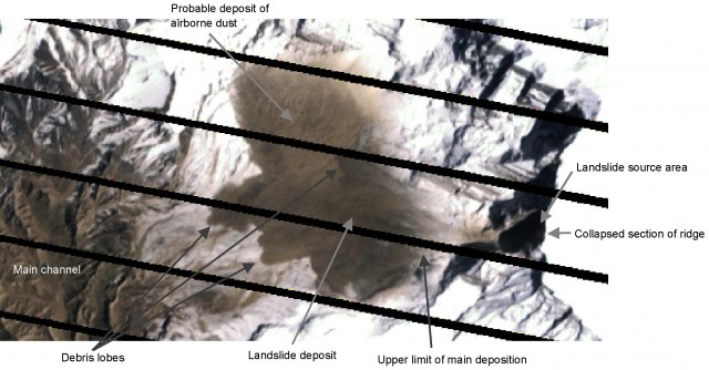
There is one aspect of the Seti River event that I do not believe we got right at the time. The great controversy about this event has always been the transition from rock avalanche to debris flow, and in particular source of the water. The confusion has been the NASA satellite image, which appears to suggest that most of the landslide was deposited on the plateau, with almost none reaching the gully system. This is the annotated Landsat 7 image that Colin Stark and I posted on this site two years ago:
..
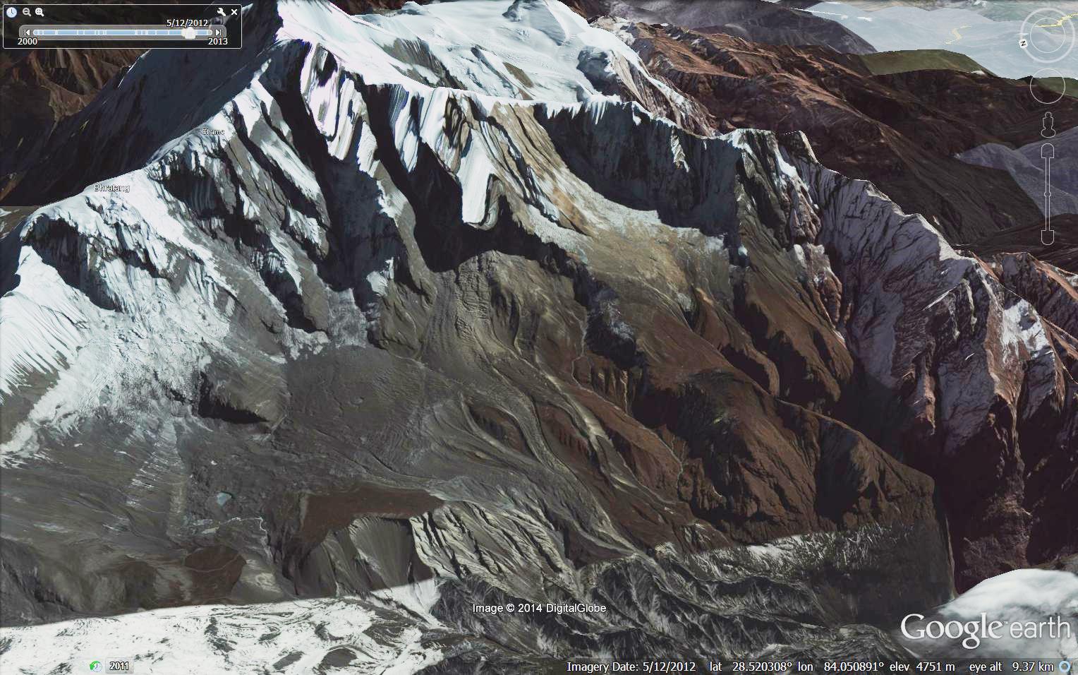
A different, and I think correct, interpretation was proposed in a paper by Jorg Hanisch and colleagues in the Journal of the Nepal Geological Society (Hanisch et al. 2013). They point out that the evidence on the ground suggests that the deposit shown in the satellite image above is actually the remains of a smaller secondary landslide. The main event flowed across the plateau and entered the main channel, leaving almost nothing behind. In fact, the Google Earth imagery that is now available of the site of the rock avalanche strongly supports this interpretation. This is a perspective image of the site of the landslide from before the collapse, collected on 24th December 2011:
..
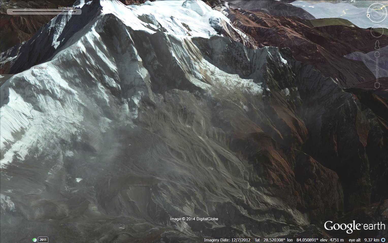
And this is the image after the landslide, collected on 12th July 2012:
 …
…
The modification to the land surface caused by the landslide is very clear, The landslide has removed almost all of the smaller topographic features, sch as crevasses and gullys. In doing so it would have entrained large amounts of ice and snow, which of course would have melted to provide large volumes of water. What is also clear from this image, as Hanisch et al. (2013) suggest, is that a large proportion of the landslide entered the main gully system, and thus formed the catastrophic debris flow that caused such devastation downstream. Thus, there is no need to invoke a more exotic mechanism for generating the mass that formed the Seti River debris flow, such as a downstream valley-blocking landslide or drainage of cave systems.
Reference
Hanisch, J., Koirala, A. and Bhandary, N.P 2013. The Pokhara May 5th flood disaster: A last warning sign sent by nature? Journal of Nepal Geological Society, 46, 1-10.
 Dave Petley is the Vice-Chancellor of the University of Hull in the United Kingdom. His blog provides commentary and analysis of landslide events occurring worldwide, including the landslides themselves, latest research, and conferences and meetings.
Very informative post with so useful research.
We are very sad to loose our 26 villagers and other native people on the accident.
Kalyan Bastola
http://www.easynepal.com