
13 July 2013
An interesting valley-blocking landslide (not a glacial lake problem) above Badrinath temple in Uttarakhand, India
Posted by Dave Petley
The debris flow disaster at Kedarnath, which is thought to have killed thousands, occurred at a sacred Hindu shrine, a site of pilgrimage that meant that there was a high concentration of very vulnerable people when the disaster occurred. Another important Hindu shrine is located in another high mountain valley at Badrinath. Floods also affected this area, and the evacuation of pilgrims has been a slow and difficult operation. In the last two days another problem has emerged at Badrinath, identified by the Indian National Remote Sensing Centre from high resolution satellite imagery. The problem is that upstream of Badrinath temple a valley appears to have been blocked by a landslide, allowing a lake to form. Now, first off it should be said that this is no Attabad – the landslide and associated lake are both much smaller than that problem. However, it is sufficiently serious to merit urgent attention. Strangely though this is being reported by NRSC as a glacial lake problem – it is not – the issue is a valley-blocking landslide as far as I can see.
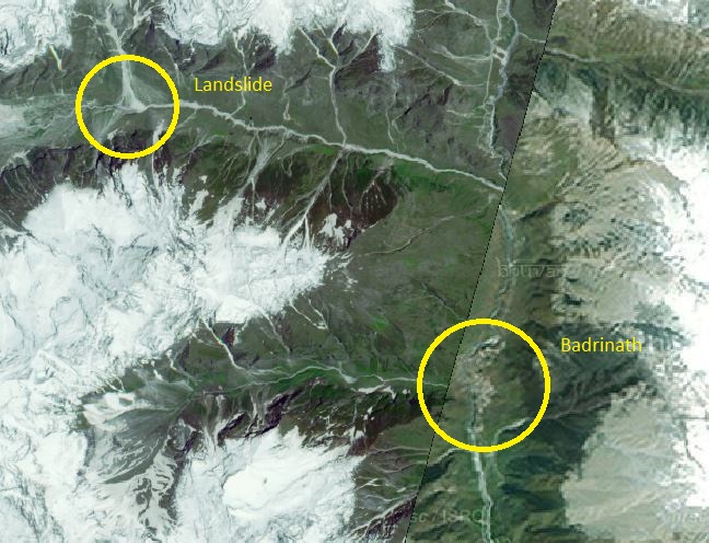
This is the setting – I have marked the location of the valley-blocking landslide and the Badrinath temple. Note that the image consists of two satellite images joined together in Bhuvan (the NRSC image viewing tool), and hence the seam across the image:
..
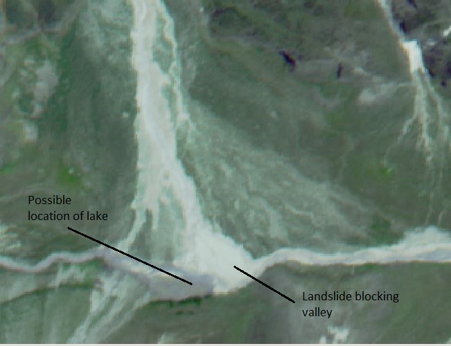
The NRSC has a report on the problem online here. The major issue is a landslide that appears to have blocked the valley – this is the site from the 21st June 2013 image on Bhuvan:
..
At the time that this image was taken, on 21st June, the problem appears to be minor. There is little evidence of a substantial amount of water being impounded, and there is some possibility that there is flow through the river downstream, suggesting that the blockage may not be complete. However, the NRSC report includes a radar image of the same site, taken on 7th July 2013:
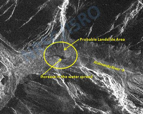
http://www.nrsc.gov.in/#
..
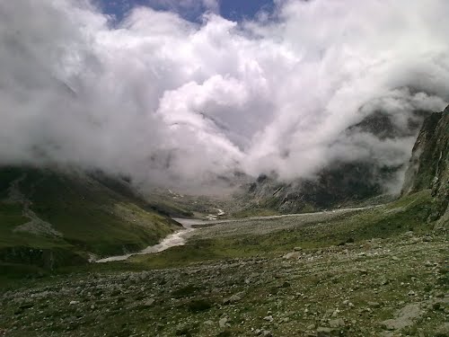
The concern here is the very dark area just upstream of the landslide. On radar images standing water appears as a very dark mass – so this is likely to be water impounded by the landslide. The volume does not appear to be large, although the lake is reportedly 450 m long, and again there is at least a suggestion in the above image that some water is flowing through the blockage. This archive Panoramio image, taken by Hitesh Bahshi, seems to show the location from downstream before the recent events. The topography suggests that a very large lake is unlikely to develop:
http://mw2.google.com/mw-panoramio/photos/medium/77811464.jpg
..
So how dangerous is this? Well, it is certainly not as dangerous as was Attabad as a breach would involve far less water. However, the potential danger might be that the flow might entrain large amounts of water and debris downslope, allowing a larger volume to strike Badrinath temple and town. This is probably not very likely in my view, but it does need further investigation. The greatest danger would be in heavy rain, as before. At this stage there is absolutely no reason to worry unduly, but someone does need to take a look at it on the ground or by helicopter, and if necessary the water may need to be released by creating a spillway. This should not be too difficult to achieve. The response to date appears to be appropriately measured, which is good to see.
NRSC desrerve great credit for identfying this hazard.
 Dave Petley is the Vice-Chancellor of the University of Hull in the United Kingdom. His blog provides commentary and analysis of landslide events occurring worldwide, including the landslides themselves, latest research, and conferences and meetings.