28 September 2012
An update on the catastrophic foundation erosion at Newburn, NE England
Posted by Dave Petley
Thanks to Chris Atkins for a very detailed email, which has greatly helped in putting this together.
BBC News is reporting the inevitable about the flats at Spencer Court, Newburn, which suffered catastrophic erosion of its foundations early this week. To the dismay of the residents the block is likely to be demolished.
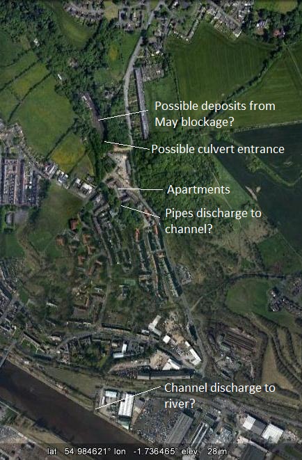
It is apparent that the underlying cause of this incident was a collapsed culvert running close to the apartments. It seems likely that this provided drainage from the stream that can be seen as the wooded area to the north of the apartment. The following shows the layout of the area, and I have speculated (based upon the Google Earth imagery) on where the various key components of the system are located:
It is clear that the initial main event at this site occurred in the very heavy rainfall in the early summer, which led to the collapse of the culvert. A quick Google Image search for Newburn culvert brings up this Flickr gallery, which appears to show the inside if the culvert before the collapse (the image is all rights reserved, so I cannot show it here). The below Youtube video reports the formation of a sinkhole in the area of Spencer Court on 17th May this year:
http://www.youtube.com/watch?v=BTyOGIF9BBc
Interestingly, the text commentary on Youtube has a quote from a local resident:
Robert Lowes, 41, who lives on the nearby Manor Grove estate said the area had been blighted by sink holes for years. Just a few months ago a post box collapsed into a hole that appeared overnight. He said: “There is subsidence all around here. “We have had other big dips in the tarmac all over the place. “I know someone who has had a huge crack in their house.”
This might suggest that the problem had been developing for some months. The heavy rainfall in June was then unable to drain through the culvert, and flooding developed upstream. This piece in the Evening Chronicle describes the development of the lake:
A half mile stretch of contaminated water has swamped Newburn Dene in Newcastle. At places the water is up to 30ft deep and covers some buildings including a stable block. Metres of pipes and 11 pumps are channeling water away from the spot where horses grazed until the water swamped the area when a culvert or underground tunnel burst in the early hours of Sunday.
I have marked the area of the lake on the Google Earth image above. It appears that the heavy rainfall of earlier this week came before the culvert could be repaired. The lake quickly reformed, and then spilled over to flow through the apartments, undermining the foundations.
Now there is going to be a key challenge to deal with this site. We are just moving into the autumn, which is often characterised by heavy rainfall associated with low pressure systems coming off the Atlantic. Thus, there is going to be an urgent need to establish drainage to prevent further damage from a recurrence of the overflow event. In addition, some work will be needed to establish how much material has been lost from the fill around the culvert in order to determine the stability of the other buildings (which may be why further evacuations have been needed this morning). Finally, of course, the culvert will need to be repaired. Northumberland Estates, who own the culvert, have issued an apology to the residents.
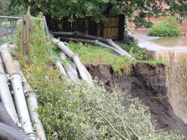
In my earlier post I mused on whether this is likely to be a failure in fill. A close look at the images of the area suggest that this is the case. This image in particular appears to show made ground:

http://www.chroniclelive.co.uk/multimedia/news/local-news/2012/09/25/floodwaters-at-spencer-court-in-newburn-72703-31904982/#2
As an interesting aside, on this forum an anonymous individual made this comment in 2008 about Newburn:
“As the dene nears Newburn the stream enters an underground culvert which originally carried it beneath a steel works. Sadly though this has now been flattened to make way for affordable housing. I wonder if the people above know what lies beneath their houses?”
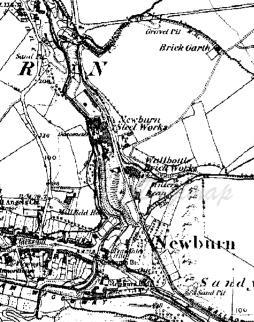
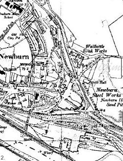
The former locations locations of the steelworks and the brickworks are clearly evident from these historic maps from the 1860s and 1930s (courtesy of Edina Digimap):

 Of course we should never forget the human cost of such an event. It is likely to have an impact on the residents of these apartments for a long time.


 Dave Petley is the Vice-Chancellor of the University of Hull in the United Kingdom. His blog provides commentary and analysis of landslide events occurring worldwide, including the landslides themselves, latest research, and conferences and meetings.