
6 June 2011
Forecasts for the 2011 global landslide season
Posted by Dave Petley
The graph below shows the average monthly occurrence of non-seismic, fatality-inducing landslides worldwide for the last eight years or so, based upon the database that I collate of mass movements that kill people (maps of the data can be found here):
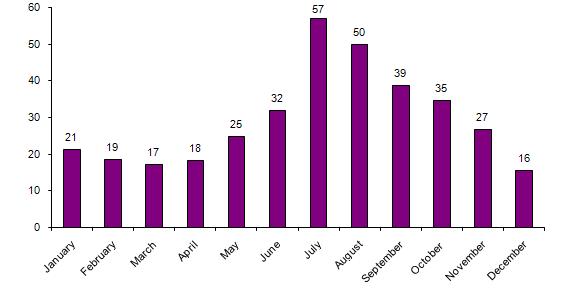 The data need to be interpreted a little carefully because of the uneven length of each month, but the seasonality of the occurrence worldwide is really striking. This peak is of course dominated by the weather conditions associated with the northern hemisphere summer – and in particular the combination of the summer monsoon in South and East Asia, the typhoon season in the NW Pacific and the Hurricane season in the Caribbean. So, at this point it is interesting to look at the long-range forecasts for each of these phenomena to see what might be in store.
So first, the monsoon in South Asia. This was of course continually in the news last summer due to the floods in Pakistan. Forecasts for the South Asia monsoon are issues by the Indian Meteorology Department. Their 2011 monsoon page provides an update on progress of the monsoon as it develops. Their long-range forecast (NB – pdf) is for an average monsoon for India:
IMD’s long range forecast for the 2011 south-west monsoon season (June to September) is that the rainfall for the country as a whole is most likely to be Normal (96-104% of Long Period Average (LPA)). There is very low probability for season rainfall to be deficient (below 90% of LPA) or excess (above 110% of LPA).
However, note that landslides are mostly triggered by short duration, intense rainfall (which this forecast does not really address) and that there is huge spatial variability in rainfall patterns. In other words, we will see hotspots of landslides occurring across South Asia, and there is no excuse for complacency. This monsoon forecast will be updated by IMD later this month.
At the moment I cannot find a long-range forecast for the monsoon in East Asia (anyone?), but much of this area has been in a state of drought. Heavy rainfall, and possible landslides, are being forecast for this week.
For the NW Pacific typhoon season, Tropical Storm Risk are forecasting a season that is also close to average. The City University of Hong Kong forecast is also for an average typhoon season, but with the caveat that landfalling events in both Southern China and Japan may be above average. The latter may be important in view of the vulnerability of the earthquake-affected areas of Japan to the impacts of intense rainfall.
For the Atlantic Hurricane season, Tropical Storm Risk are forecasting a season that is substantially above average, whilst the Colorado State University (Bill Gray) forecast is even more pessimistic, with indications that activity will be substantially above average in this basin.
As an aside, Ryan Maue at Florida State University maintains a wonderful web page monitoring global tropical cyclone activity. It is fascinating to see that worldwide the level of activity remains at historically low levels, for reasons that are far from clear. For updates on severe weather events around the world I recommend Jeff Masters’ Wunder blog in addition to Dan Sattersfield’s blog on this site.
 Dave Petley is the Vice-Chancellor of the University of Hull in the United Kingdom. His blog provides commentary and analysis of landslide events occurring worldwide, including the landslides themselves, latest research, and conferences and meetings.
Landslide report from New York State, the Adirondack Mountains:
http://tinyurl.com/6g5cu9x
The headline reads:
“Slow-motion landslide takes Adirondack dreams: Couple scramble to save their dream home from Adirondacks landslide”
Additional evacuations in Chile due to concern for avalanche/lahar: http://www.terra.cl/actualidad/index.cfm?id_cat=302&id_reg=1665193&titulo_url=Amplian_zona_de_evacuacion_a_Ri%C3%B1inahue_Bajo_por_riesgo_de_aluvion
I have heard an unconfirmed report of river blockage. I’ll let you know if I find conformation.
M.
Info on lahars:
http://www2.sernageomin.cl/ovdas/ovdas7/informativos2/Informes/Reportes/RegionXIV/REAV_N31_Los-Rios_06062011.pdf
[…] I noted in my previous post, we are now just entering the global landslide season. In the last week there has been a marked […]
From Nepal
Unlike the monsoon rainfall of the last two years, the season this year will see plenty of showers, the Meteorological Forecasting Division (MFD) has said……
The Kathmandu Post, Kathmandu, 19 June 2011, web edn., http://www.ekantipur.com/the-kathmandu-post/2011/06/18/nation/weathermen-forecast-good-rains-this-season/223026.html