
10 August 2010
Updates for Pakistan, China and India flood and landslide crises, 10th August
Posted by Dave Petley
As yesterday, this is a brief review of the state of play with the three substantial landslide and flood crises in Asia.
1. Pakistan
The flood wave continues to work its way down the Indus, and is now in the Province of Sindh. As forecast, heavy rainfall exacerbated the situation yesterday, with totals of over 100 mm in some areas of the province. Kyber-Pakhtunkhwa also saw falls of 30 mm or more in some areas. Whilst not enough to cause the sort of devastation that we have seen of late, this is sufficient to keep river levels topped up.
Working our way down the Indus, the second flood at Besham has now peaked and the hydrograph is showing a rapid decline.
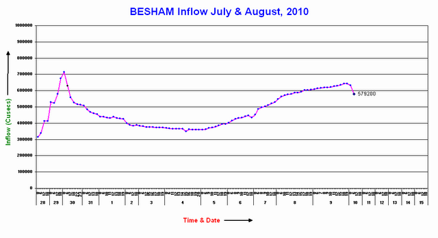
The peak flow in this econd flood was lower than in the first , but was still substantial. This water will of course have to work its way down the Indus over the next ten days. It will be interesting to see how this flood looks when it reaches Taunsa.
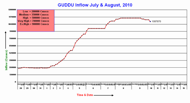
Moving down to Guddu, the peak discharge appears finally to have passed, meaning that water levels will be slowly falling. Note however that if the flow behaviour at Taunsa is a guide, the rate at which the water levels fall will be quite slow, meaning that the people have several more days before they will be able to start rebuilding their lives. Note also that the flood level is still above the exceptionally high level. The flat peak component of the flood record causes me to reiterate my suggestion yesterday that the hydrograph shown below has not accurately captured the peak flow:
Going south again, and the main concern is now at Sukkur, where the hydrograph appears to be suffering the same problems of saturation at the peak:

Some media reports have suggested that the peak flow here is actually 1.2 million cubic feet per second. The media are also reporting concerns about the safety of the Sukkur barrage, with several reports suggesting that deliberate breaches of levees are being considered to try to reduce the peak flow. It seems that a similar exercise was undertaken upstream at Ghouspur, with the inevitable destruction that followed. However, it is important to understand that these barrages provide irrigation for vast areas of productive agricultural land that is vital for the sustenance of the population of Pakistan. Deciding on how to protect them is not an easy task.
However, as at Attabad the apparently poor communications strategy of the authorities is unfortunate. Whilst putting the hydrographs online is a good step, it would be sensible to accompany this with a decent explanation of what is happening, where the threats lie, and the action that might be needed to mitigate them. Whilst this would not prevent the destruction, at least people might understand why particular courses of action are being followed.
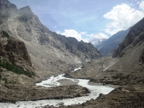
Finally, for northern Pakistan the Pamir Times has provided two updates in the last 24 hours on the Attabad situation. Most importantly, the water level is now falling, having apparently risen by 6 feet (about 1.8 metres) at the peak of the floods, which caused further widespread destruction. Meanwhile, they continue to note that other landslides have caused severe hardship, and that the Hunza was blocked at Rahimabad to the north of Gilgit. As far as I can tell Rahimabad is in the valley shown in the Google Earth image below:

Meanwhile, the Pamir Times has also provided some new images of the state of the Attabad barrier itself:
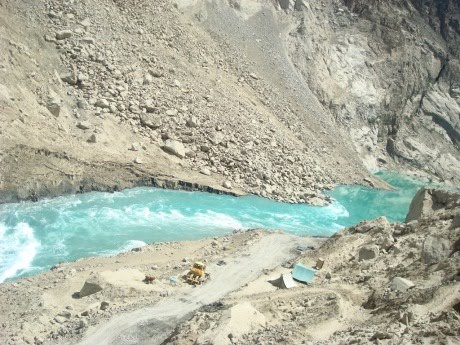
These appear to indicate little change in the state of the dam over the last couple of weeks. Operations to lower the spillway level have yet to start, but it is heartening to see in some of the images that a monitoring team appears to still be on the site.
2. China
Rescue operations continue at the Zhouqu landslide site, where the number of known fatalities is now 337. The reported number of missing people is 1,148. There can be little chance of recovering many further survivors, although one victim was recovered alive today. The state media are reporting some tales of real anguish in the aftermath of the disaster, exacerbated of course by the “one child” policy in China. The government is attributing the disaster to the normal villains – poor geological conditions, the recent drought, the heavy rainfall, and the aftermath of the 2008 earthquake. This is all likely to be true to at least some degree, but there may be other factors as well, most notably deforestation and the legacy of mining activities. The internet age has spawned a wave of amateur investigative journalism in China. This All Voices page reviews recent postings of Chinese documents about the landslide hazard in Zhouqu. Whilst I am naturally sceptical of some of this material, it does appear that the risks to communities posed by landslides in these mountains is well-documented. In particular, this newspaper article, from 2008, identifies that the slope problems at Zhouqu are sufficiently serious that they have been the location of various studies by Japanese landslide scientists. However, to be fair to the government, the range of landslide problems in the aftermath of the 2008 earthquake is so serious that prioritising and finding resource to mitigate appropriately is impossible. Expect more landslide disasters in central China in the coming years.
Two images have appeared in the last 24 hours that demonstrate the magnitude of this slide. This AP image shows the landslide from the opposite bank:

I would really like to see the source of this huge debris flow – has anyone seen an aerial image of the upper reaches of the track as yet?
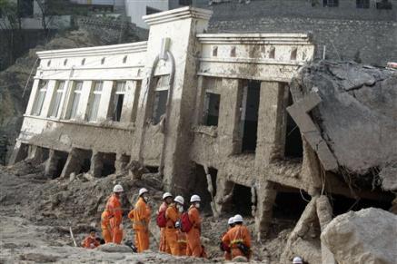
And this AP image illustrates the likely velocity of the movement, given away by the mud deposit on, and indeed in, the upper part of the building:
Finally, unfortunately tropical storm Dianmu is moving northwards off the east coast of China. Although it is unlikely to landfall in China itself, expect heavy rainfall across eastern and central China. Given the intensity and magnitude of the recent rainfall, this is potentially deeply problematic.
3. The Ladakh debris flows in India
The forgotten disaster amongst everything else that is going on is the Ladakh debris flows that occurred on Friday. To date the number of known victims is reported to be 165 people, with a further 500 thought to be missing (with very little chance of survival now). However, Save the Children is reported to believe that the true toll is likely to be in excess of 1,000 because several affected villages have yet to be accessed. Localised heavy rainfall continues in the area, disrupting relief operations and causing further damage.
One of the most seriously affected towns was Choglamsar. This is the settlement in the foreground of the perspective Google Earth image below – the presence of the huge debris fan in the background is a clear sign of the processes that have allows the formation of the comparatively flat areas upon which the town is built:
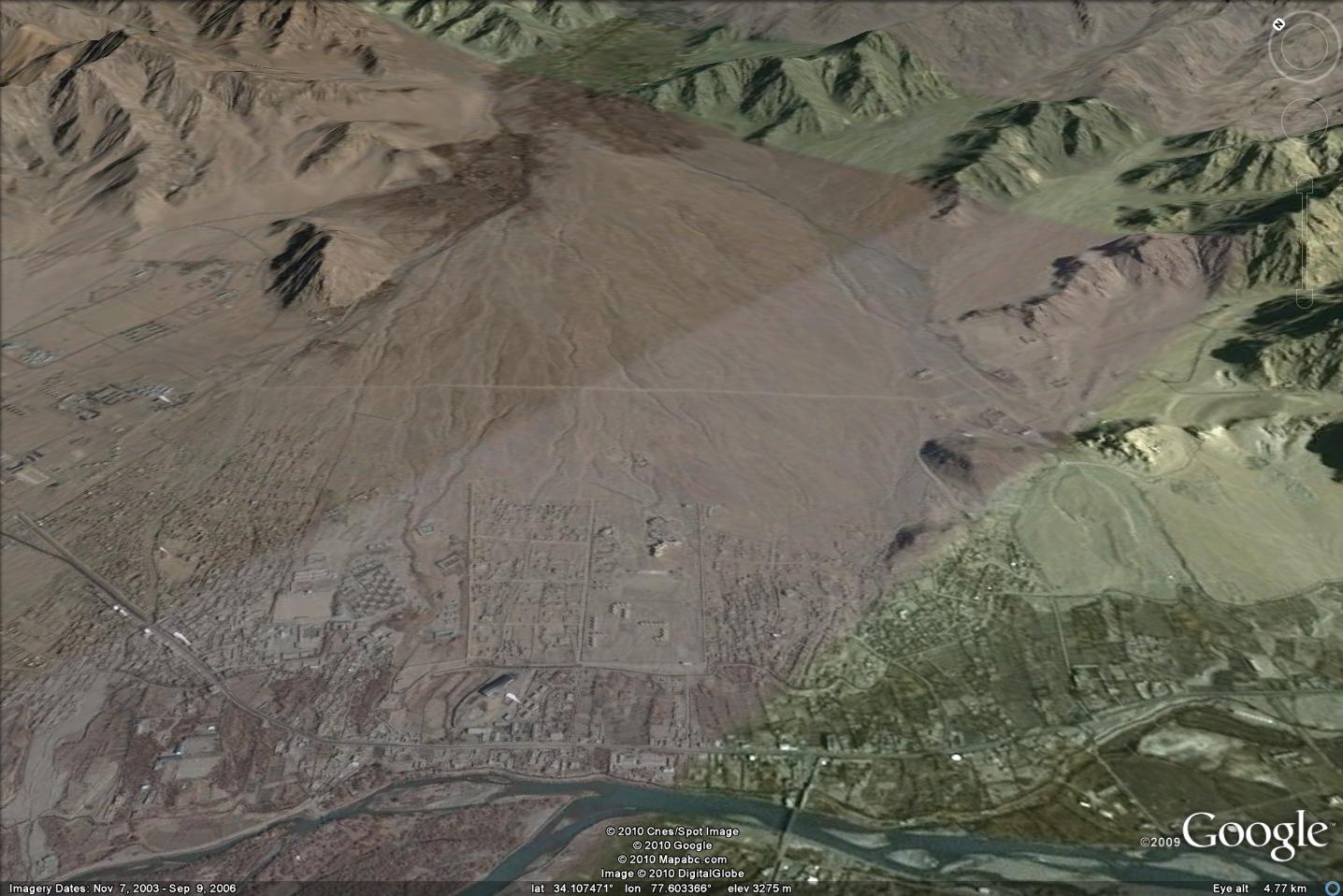
Protecting the town against repeats of this event is not going to be an easy task, but debris flows must be expected on a fan such as this.
I will try to provide further updates tomorrow morning, or sooner if events require.
 Dave Petley is the Vice-Chancellor of the University of Hull in the United Kingdom. His blog provides commentary and analysis of landslide events occurring worldwide, including the landslides themselves, latest research, and conferences and meetings.
Excellent report.In Pakistan,the situation is very bad. There is shortage of supplies in places, access is difficult due to weather and breakdown of bridges ,roads etc.Unfortunate as it may sound, the world civil society seems not to be coming forward with aid/assistance at the scale it should. The number and scale of the present floods is larger than 2004 Tsunami,Haiti EQ or 2005 Kashmir Earthquake. Even the philanthropist in Pakistan are not donating to the Government in large numbers and with large donations.
Hello Dave,here a video related to the Zhouqu disaster, showing the 3d map of the area and where the land slides came from resp. where they blocked the river.http://english.cntv.cn/program/newsupdate/20100811/100899.shtml
Aerial photos of the Zhouqu slides before and after at http://www.bbc.co.uk/news/world-asia-pacific-10925531
hi, Is there any chances that Pakistan Flood water enter India. As now it is very close to indian border
India is filling up its dams and will soon unleash water which will head to Pakistan and wreak more havoc. Anyone for Kalabagh Dam
@anonymous Is there any other option for India after filling the Dam, He will let the water to follow natural Way. This big Flood is a lesson Not only for the Pakistan but whole of World, We should take suitable action to stop climate change & keep the Path of River Clean & every year, Dig the sand from rivers. Blamig India any Other Nation is worth meaningless & just diverting public mindset from the actual issue.