
7 July 2010
New EO-1 ALI satellite image of Attabad
Posted by Dave Petley
NASA have released a new satellite image of the Attabad landslide and lake, collected by the Advanced Land Imager (ALI) instrument on the EO-1 satellite on Saturday 2nd July. The images are excellent, showing both the lake and the dam and spillway with only limited cloud cover (note that north is to the right on these images):
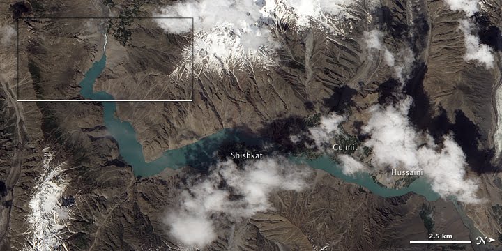
The box indicates the following close-up image:

They also link to this site, which is appreciated. Meanwhile, the NDMA site suggests that the lake level has dropped by about 3.5 inches (about 9 cm).
 Dave Petley is the Vice-Chancellor of the University of Hull in the United Kingdom. His blog provides commentary and analysis of landslide events occurring worldwide, including the landslides themselves, latest research, and conferences and meetings.
The length of the spillway slope appears to be around 800m from this image, which suggests an overall gradient of no more than 15%. This relatively shallow slope ought to be a significant factor when considering possible failure mechanisms. The matrix appears heavily boulderised (NDMA should confirm by resistivity measurement). The white colour of the spillway (almost along its entire length) clearly indicates that the channel bed is now being armoured by boulders. As further fine materials are washed through, the interlock forces between remaining boulders will increase and, considering the relatively shallow slope, should provide more than enough resistance to shear (for that type of failure mechanism). I can not see how a shear surface (of any significant length) could possibly develop in this material.
makes sense..
Dr. Dave- How many, in percentage terms, major landslides blocking rivers survive?You made it clear that your expectation was for this dam to washout, and that may still happen, but it's survived far longer than many others.What I find very interesting is that we have been able to witness the formation of a relatively large lake. Normally geological time is stretched out beyond one's life.Once again, thanks for providing the forum for open discussion.
Gah! My survive question is not well-formed, but I hope given the context, it's not that unclear. That said, I'll go further on the issue of "survive."When I say survive, I guess it needs a time frame, so I will put a 14 month time frame after over-topping (14 months after over-topping should be enough so that the year's peak flow is included). In other words, if the dam lasts the over-topping plus 14 months, I will consider it to have survived. We all know that it will eventually fail, given enough geological time.Moving forward, I suppose one could develop a distribution of failure times, with the initial landslide being time zero. Some dams fail before over-topping, others fail within a week of over-topping, others last much longer.Based on your previous posts, my guess is that most dams fail prior to two weeks after over-topping, regardless of failure mechanism.I'd like to add, however, that the Naches landslide (Washington state, previously covered here) did not span the entire Nile Valley. It did, however, dam the Naches river, but the flow was quickly restored around the dam. The dam, itself, would hold for many years, since the water took a different path.
Consider the landscape and ask yourself, how many previous landslides have blocked the Hunza, forming a large lake? I don't see any. Probably lakes don't last long enough to leave even a record of their wave action.On the other hand, we know that the impounded water only amounts to about six months of mostly low river flow. So perhaps this dam can stay in place longer than most. Google earth's view suggests that much of the largest rock material ended up on top of the highway. The material that we regard along the spillway is not that big.My guess is that the real destruction of this dam will occur in next spring's thaw. 25KM of ice on the lake will make for an interesting time. Will there be an ice dam?By the way, if you paste the EOS kmz file link into Google maps' dialog bar, you can see the spillway as of July 7th. The image is very low resolution compared to the default in Google Earth view.(spillway site is here)
BeforeGoreKneel- I've done a bit of hiking. The Rockies and Cascades (part of the Ring of Fire) both are geologically relatively new ranges. The Cascades have plenty of active volcanoes.That said, I have observed a good number of landslide lakes that exists. I have not hiked up the Hunza, so I have not taken a complete survey. I also never see the ones that failed and washed away.My personal observations regarding the rocks in the dam is what lead me to believe that the dam would survive. A couple of months ago it was suggested that the river could move all the boulders, no matter how large. I brought up the issue of entrainment velocity.In summary, I am considering far more than just one river. In fact, I've seen the dams in higher elevations (higher as contrasted to the general elevations for the area. The North American ranges are nothing compared to Himalayas.).
Thanks as always Dave for tracking this and other slides. I routinely look at the NASA Image of the Day and they as you noted have the Hunza River image. However, I found the image slightly different than the one you posted (less clouds). But the main difference I noted and this might be an artifact of clipping images, but it appears that the image of the day close up caught a slide taking place as the image is obscured by dust. Perhaps it could have been wind but I saw no other dusty areas.In regard to Tropical’s comment, a chart might be interesting. I will note that the Columbia River was entirely blocked in the early 1700s east of Portland. That blockage appears to have slowly eroded and there is evidence of other past blockages that lasted several years at least.BeforeGoreKneel – A carful look at higher resolution satellite images indicates several past probable lakes in the valley as there are a number of terraces and filled in side stream channels. In addition, there is downstream evidence of very large scale floods that may be associated with catastrophic dam failures. Alternatives could be glacial damming and/or glacial outburst floods.
In the cold hard light of day, I can see I should have written this:"Consider the landscape and ask yourself, how many previous landslides have blocked the Hunza, forming a [INSERT HERE, permanent or long lasting] large lake."I'd like to see a profile of the river under the lake and spillway and an estimate of the landslide dam. And while I'm asking, how about some guesses at how long the Hunza would take to fill up a lake with sendiment.
In geology, there is no such thing as permanent, and long-lasting is a question of magnitude. There are plenty of people who might suggest this dam is already long-lasting.
Another example of the impact of a landslide:http://www.oregonlive.com/lake-oswego/index.ssf/2010/07/lake_oswego_man_cleared_in_landslide_that_destroyed_downhill_neighbors_home.htmlIn summary, a landslide destroys a 5,000 square foot home, and the owners blame the property owner. After trail, the landowner is not responsible for the damage.Given the status of the housing market, it's tough to determine value. Just for the sake of convenience, I am going to provide a round number. The margin of error is probably 20%.Located in the Portland, Oregon area, this home was probably worth $1M USD.The way the article is written suggests that the victim of the landslide didn't have landslide insurance.
You know, you just look at the impressive topography there in the photographs and videos, the steep slopes of bare rock angling down into narrow river channels from towering mountains, and it is hard to imagine that this sort of landslide and blockage has not been going on episodically for millions of years (interrupted only by being covered by glaciers). Many cubic kilometers of rock have already been removed from that area, and those mountains are still rising. You see the other villages precariously situated at the base of these steep slopes, like Attabad was, and it hard not to get the sense that what happened to Attabad is ultimately going to be the fate of all of them, sometime in the future. Like the threat of tsunamis for people who inhabit low lying coastal areas, it has be considered an ever present risk; not a matter of “if”, only a matter of “when”.Dave mentioned that the remnants of a recent prior landslide/blockage reside just downstream of the current one. I would think that if these sorts of natural dams had any sort of longevity, the region would be populated with lakes. It is not.
The presence of shelves can be indicative of fossil shorelines; i.e. these lakes come and go. The slabs we see in this landslide may contribute to the duration of these lakes as they may be resistant to erosion but not earthquakes.George
In human time, a year is a decent amount of time. In geological time, it's essentially nothing.My original idea was to look at the number of dams that made it 14 months beyond the over-topping.There could have been hundreds of these dams that made it 14 months, but fell apart after within 20 years, more or less; 20 years is so close to zero time in geological terms.The idea that an earthquake could cause liquefaction is right on point. This dam may hold until a significant quake hits, and there is no way to know how soon that might happen. To the best of my knowledge there is no model that successfully predicts when earthquakes will happen. We know that there are high activity zones, but a given zone might remain quite for an extended period of time, or it might be very active. Southern California is a good example–when will "the big one" hit? No one knows for sure.Without proof or support, it seems plausible that if liquefaction were to occur, there could be sufficient water velocity and volume to entrain much of the debris. In this specific example, we know that some of the debris is the size of boxcars, so not all of it would be moved, but maybe enough to significantly reduce the high of the dam.Finally, I hope this goes without saying, but it seems necessary given the mixing of geological time and human time. This dam could make it 100 years–a human lifetime. The dam could outlast someone born today, yet 100 years in terms of geological time, and the observation that other lakes are not present, 100 years is very, very close to zero–close enough to call nothing?Let's go back 2,000 years (still a very short time in terms of geological time), over the past 2,000 years, how many lakes lasted 100 years?A few years ago I was out on Mt. Mazama. Mazama started its formation about 400,000 years ago. A significant event happened about 8,000 years ago. Who knows what it looked liked for the 400,000 years until 8,000 years ago. (There is more than 8,000 years worth of error in the 400,000 year estimate, so 400,000-8,000=400,000.)How often do 400k+ year volcanoes blow? St. Helens blew in 1980, but there are plenty of other active volcanoes in the Cascade range.Rainier has Little Tahoma Peak, the remnant of Rainier being much larger, and Little Tahoma Peak is less than 500,000 years old.In any event, if we were to look back over the last 500,000 years, which is difficult to do, I wonder how many lakes have formed and washed away on the Hunza, and how long did the lakes last?
In human time, a year is a decent amount of time. In geological time, it's essentially nothing.My original idea was to look at the number of dams that made it 14 months beyond the over-topping.There could have been hundreds of these dams that made it 14 months, but fell apart after within 20 years, more or less; 20 years is so close to zero time in geological terms.The idea that an earthquake could cause liquefaction is right on point. This dam may hold until a significant quake hits, and there is no way to know how soon that might happen. To the best of my knowledge there is no model that successfully predicts when earthquakes will happen. We know that there are high activity zones, but a given zone might remain quite for an extended period of time, or it might be very active. Southern California is a good example–when will "the big one" hit? No one knows for sure.Without proof or support, it seems plausible that if liquefaction were to occur, there could be sufficient water velocity and volume to entrain much of the debris. In this specific example, we know that some of the debris is the size of boxcars, so not all of it would be moved, but maybe enough to significantly reduce the high of the dam.Finally, I hope this goes without saying, but it seems necessary given the mixing of geological time and human time. This dam could make it 100 years–a human lifetime. The dam could outlast someone born today, yet 100 years in terms of geological time, and the observation that other lakes are not present, 100 years is very, very close to zero–close enough to call nothing?Let's go back 2,000 years (still a very short time in terms of geological time), over the past 2,000 years, how many lakes lasted 100 years?A few years ago I was out on Mt. Mazama. Mazama started its formation about 400,000 years ago. A significant event happened about 8,000 years ago. Who knows what it looked liked for the 400,000 years until 8,000 years ago. (There is more than 8,000 years worth of error in the 400,000 year estimate, so 400,000-8,000=400,000.)How often do 400k+ year volcanoes blow? St. Helens blew in 1980, but there are plenty of other active volcanoes in the Cascade range.Rainier has Little Tahoma Peak, the remnant of Rainier being much larger, and Little Tahoma Peak is less than 500,000 years old.In any event, if we were to look back over the last 500,000 years, which is difficult to do, I wonder how many lakes have formed and washed away on the Hunza, and how long did the lakes last?
In human time, a year is a decent amount of time. In geological time, it's essentially nothing.My original idea was to look at the number of dams that made it 14 months beyond the over-topping.There could have been hundreds of these dams that made it 14 months, but fell apart after within 20 years, more or less; 20 years is so close to zero time in geological terms.The idea that an earthquake could cause liquefaction is right on point. This dam may hold until a significant quake hits, and there is no way to know how soon that might happen. To the best of my knowledge there is no model that successfully predicts when earthquakes will happen. We know that there are high activity zones, but a given zone might remain quite for an extended period of time, or it might be very active. Southern California is a good example–when will "the big one" hit? No one knows for sure.Without proof or support, it seems plausible that if liquefaction were to occur, there could be sufficient water velocity and volume to entrain much of the debris. In this specific example, we know that some of the debris is the size of boxcars, so not all of it would be moved, but maybe enough to significantly reduce the high of the dam.
I hope this goes without saying, but it seems necessary given the mixing of geological time and human time. This dam could make it 100 years–a human lifetime. The dam could outlast someone born today, yet 100 years in terms of geological time, and the observation that other lakes are not present, 100 years is very, very close to zero–close enough to call nothing?Let's go back 2,000 years (still a very short time in terms of geological time), over the past 2,000 years, how many lakes lasted 100 years?A few years ago I was out on Mt. Mazama. Mazama started its formation about 400,000 years ago. A significant event happened about 8,000 years ago. Who knows what it looked liked for the 400,000 years until 8,000 years ago. (There is more than 8,000 years worth of error in the 400,000 year estimate, so 400,000-8,000=400,000.)How often do 400k+ year volcanoes blow? St. Helens blew in 1980, but there are plenty of other active volcanoes in the Cascade range.Rainier has Little Tahoma Peak, the remnant of Rainier being much larger, and Little Tahoma Peak is less than 500,000 years old.In any event, if we were to look back over the last 500,000 years, which is difficult to do, I wonder how many lakes have formed and washed away on the Hunza, and how long did the lakes last?
Dr Dave,Please look at the pre-landslide satellite imagery of the exact place and you will realize that it is extremely difficult for the dam to fail on its own.It will be impossible to deepen the spillway anymore untill the water level reduces below the lowest point of the spillway.That will happen only in winters, which are harsh and severe in this part. Work may not progress during such adverse weather conditions and in a landslide prone area.After reduction in water level if and when it happens, the Karakoram Highway may be reconstructed. This seems to be a very remote possibility.The IDPs of last earthquake in Muzaffarabad are yet to return home.I sincerely pray to Allah The Merciful that the situation for Gojal improves at the earliest.
For Longevity of dams look at this PPT by Dr David Petley relating to Attabad (slide 8)http://www.authorstream.com/Presentation/Dr_Dave-393289-10-03-attabad-pakistan-landslide-disaster-hazard-science-technology-ppt-powerpoint/
In 2004 there was a road sign just north of Zost on the KKH into China and only about 2 hours from Hunza Attabad lake. The sign read "Landsliding". At first I thought it was poor use of English. However the debris on the road and the periodic but continuous bouncing of stones and pebbles across the road, both when I traveled up and still when I traveled down again about 3 hours later, attests to Geology being well and truly in action in this area ….and visibly in action at that.
In 2004 there was a road sign just north of Zost on the KKH into China and only about 2 hours from Hunza Attabad lake. The sign read "Landsliding". At first I thought it was poor use of English. However the debris on the road and the periodic but continuous bouncing of stones and pebbles across the road, both when I traveled up and still when I traveled down again about 3 hours later, attests to Geology being well and truly in action in this area ….and visibly in action at that.