
9 November 2009
El Salvador landslide disaster
Posted by Dave Petley
The nature of the landslide disaster in El Salvador caused by Hurricane Ida is now becoming a little clearer. The largest event appears to have happened in the town of Verapaz, where it appears that a debris flow hit and destroyed part of the town. The reported death toll is 16 people, with a further 47 thought to be missing.
There are two intriguing aspects to this landslide. The first is that the maps seem to show that Verapaz is some distance from the San Vicente volcano (also known as Chichontepec volcano) from which the landslide (probably actually technically a lahar) came, as the Google Earth image below shows:
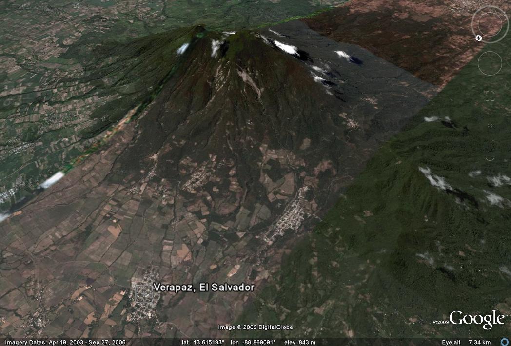 So, I wonder whether the landslide actually affected this town – in which case it is very large indeed- or whether it was one of the smaller communities nearer to the volcano.
Second, this area was affected by an earthquake on 13 February 2001, which killed over 300 people. www.elsalvador.com has an interesting comparison image:
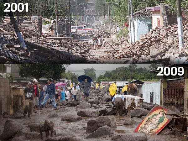 This is clearly not the same street.
Acciording to this abstract, In that earthquake two landslides were triggered on San Vicente volcano (the volcano shown above). Part of the abstract states (note my emphasis):
“Large landslides dammed two major rivers, the Río El Desagüe and Río Jiboa, and two large slides occurred on Volcán San Vicente. The ±1.5-million-m3 Río El Desagüe landslide temporarily dammed the river and formed a shallow, 1.5-km-long lake, but the dam has been overtopped and is stable. The ±12-million-m3 Río Jiboa landslide blocked about 700 m of the valley with debris composed of poorly consolidated tephra, and the upstream lake could potentially have been as deep as 60 m and about 2 km long. A 20-m-deep spillway was excavated to decrease the maximum lake volume and reduce the possible catastrophic failure of the unstable landslide dam. On the northern flank of Volcán San Vicente, ±250,000 m3 of loose landslide debris filled the upper part of Quebrada El Blanco; remobilization of this material in debris flows could inundate part of a downstream village. On the volcano’s northwest flank, ±200,000 m3 of lithified andesite blocks slid in the upper part of Quebrada Del Muerto, but this material will not likely remobilize and threaten downstream settlements..”
Verapaz is to the north of the volcano.
The presence of potentially dangerous landslides on the northern flank of the volcano is fairly clear:

 Dave Petley is the Vice-Chancellor of the University of Hull in the United Kingdom. His blog provides commentary and analysis of landslide events occurring worldwide, including the landslides themselves, latest research, and conferences and meetings.
TRABAJO MUY INTERESANTEJaime Suarez