
20 October 2009
Typhoon Lupit (Typhoon Ramil) continues to threaten Luzon
Posted by Dave Petley
Latest update here
Typhoon Lupit (Ramil) has now resumed its westward progress and remains on track to cross the northern part of Luzon in the Philippines: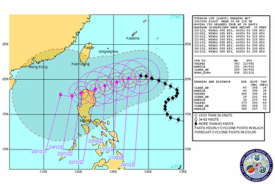 The typhoon has weakened somewhat over the last few hours, with maximum sustained wind speeds now in the order of 85 knots. This weakening appears to be associated with some drier air that surrounded the typhoon, disrupting its organised circulation. However, there is now some evidence that it is stabilising and the eye is reforming. The typhoon is likely to cross an area of warmer water as it approaches Luzon, meaning that it may re-intensify somewhat:
 NOAA eTRaP data provides an estimate of the likely precipitation associated with the storm over the next 24 hours. This is useful as the typhoon approaches land, but for now it provides a helpful indication of the levels of rainfall associated with the storm:
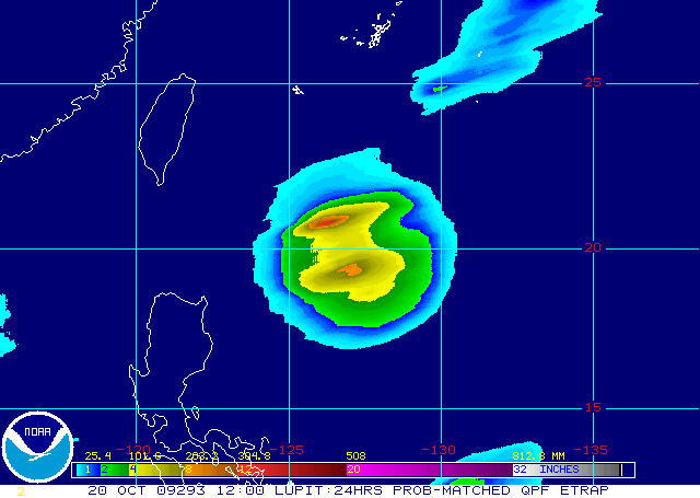 This storm continues to be the source of very serious concern. Based on its current quite low rate of movement (8 knots) the eye is likely to make landfall on Friday, although of course the outer rain bands will start to affect the area some time before that.
 Dave Petley is the Vice-Chancellor of the University of Hull in the United Kingdom. His blog provides commentary and analysis of landslide events occurring worldwide, including the landslides themselves, latest research, and conferences and meetings.