
15 September 2009
Fatal landslides in S. Asia in 2009
Posted by Dave Petley
The key driver of landslides in S. Asia is the SW (summer) monsoon, which brings prolonged and sometimes heavy rainfall across much of the Indian subcontinent. This year the monsoon has been comparatively weak so far, with only a month or so to go. Indeed, the Indian Institute of Tropical Meteorology maps of the total monsoon rainfall give a picture of considerable rainfall deficit, although it should be noted that heavy rainfall in the last few days may have started to reduce this: So I wondered to what degree this is being reflected in the landslide pattern for S. Asia. The graph below shows the monthly occurrence of rainfall-induced fatal landslides for S. Asia for the period 2002 to 2008, with the 2009 figures up to the end of August included (click on the graph to view a bigger version in a new window):
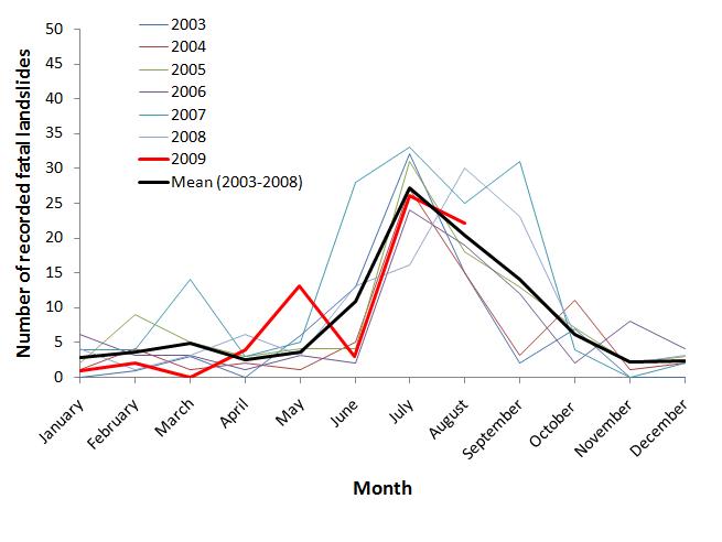 The black line is the long term average, and red line is 2009. I have used a lighter line for previous years to make the graph clearer. As I have pointed out previously for similar graphs, this graph shows clearly the impact of the monsoon, with a clear, asymmetric summer peak and low levels the rest of the year. Note that there is some inter-annual variation, with 2007 and 2008 varying somewhat from the patterns seen in other years for reasons that are not at all clear.
So what of 2009? Well, perhaps surprisingly 2009 shows a very unexceptional picture. May was somewhat above average, and June below, whilst July and August are almost exactly as per the long term mean. There is some evidence that in previous El Nino years September has been the month with the most intense rainfall in S. Asia, so it will be interesting to see what is to come.
 Dave Petley is the Vice-Chancellor of the University of Hull in the United Kingdom. His blog provides commentary and analysis of landslide events occurring worldwide, including the landslides themselves, latest research, and conferences and meetings.