
15 July 2009
June 2009 fatal landslide map
Posted by Dave Petley
A little late, but here is the map of fatal landslides for June 2009. Regular readers will note a change in the quality of the map (for the better I hope). My achievement of the week is to teach myself GIS from scratch, so that now I can plot the data on decent quality maps. So here it is, plotted on the SRTM digital terrain model (Click on the map for a better view in a new window):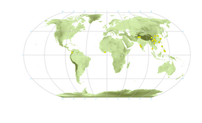 In total I recorded 22 landslides killing 155 people worldwide. Each dot above represents a single landslide. Sharp eyed readers will note that there is one missing from the above – there is a landslide in China that I have not yet located. The number killed is well below average (255 fatalities) for June, primarily because there are far fewer landslides in S. Asia than is normal for this time of year.
 Dave Petley is the Vice-Chancellor of the University of Hull in the United Kingdom. His blog provides commentary and analysis of landslide events occurring worldwide, including the landslides themselves, latest research, and conferences and meetings.
Hai sir, 15 landslides in Kerala in Wayanad, Kozhikod and Malappuram districts yesterday (15 July). Total from the beginning of the monsoon in June is 16.1 person (55 year old woman) died in Pulingal Peringulam mala Vellamunda panchayath in a debris flow. (Malayalamanoramaonline.com)with regardsSekhar
Dear Sir,Update.16 July – 1 more death due to landslides at Neelimala, Wayanad district, Northern Kerala.This makes it 3 in total since the beginning of this year's monsoon in Kerala.with regardsSekhar