
13 May 2009
So what have we learnt from the Wenchuan (Sichuan) Earthquake?
Posted by Dave Petley
Driving home from work last night, and bored with listening to endless discussions on the radio about the ways in which politicians use the system to personal gain, I started pondering what we have learnt from the Wenchuan Earthquake a year ago. The media yesterday understandably focused on collapsed schools. We have known for years that critical buildings in earthquake zones need seismic reinforcement, so this is hardly new. These are the key things that I think we have learnt (you may have more, so I welcome comments):
1. Our current rapidly-generated maps of the distribution of earthquake shaking are not good enough.
In China it is clear that the area of maximum damage occurred on the hanging wall (NW side) of the fault, with the peak being very close to the surface trace of the fault. Many of the early maps suggested that maxim,um damage would be in a zone centred around the epicentre. Unfortunately this meant that at least a part of the rescue effort was misdirected. The need for strong motion instruments across an earthquake-vulnerable area that can telemeter (send) the data back to a central station is clear. This is what happened in 1999 in Taiwan. Additionally, further work is clearly needed to allow the rapid generation of reliable shake maps.
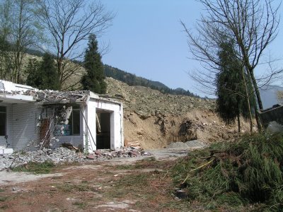
2. Communications are critical.

In China there was a major problem with communications from the most seriously-affected areas. With no telephones or power, and with all of the roads blocked by literally hundreds of landslides, getting information out about the impact proved impossible. This was compounded by a lack of understanding from the Chinese government about the likely level of damage. On the afternoon of the earthquake the Chinese Premier Wen Jiabao ordered that the roads to the epicentral areas should be reopened by before 12 p.m the day after the earthquake. Clearly there was no comprehension of what things were like in the mountain regions – and Wen is a geologist! This is not a criticism of Wen or the Chinese government – how could they possibly have known that things were so bad – but rather of the landslide community – of which I am a part – for failing to make governments aware of the implications of landslides in mountainous earthquake zones (see below).
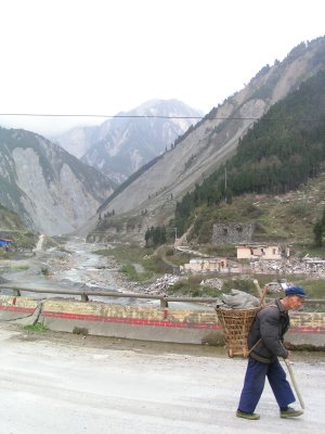
3. Landslides play a major role in mountain area earthquakes.
Until now the earthquake community has failed to appreciate the major role that landslides cause in earthquakes in upland areas. About a third of the fatalities occurred as a result of landslides; landslides also to a large degree prevented the delivery of aid; landslides blocked valleys causing a major secondary hazard (see below); and landslides now generate much of the long term hazard in the affected areas.
4. Valley blocking landslides can be mitigated.
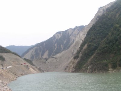
This is the first large earthquake in modern times that has created very large numbers of valley-blocking landslides. The Chinese demonstrated that these hazards can be successfully mitigated, but that it requires the availability of the right tools, experience and resources. The Chinese achievement is extraordinary – I wonder if the rest of the world could cope so well?
5. Satellite tools are still not up to the job.

For years we have been hearing that satellites provide the capability to get an almost instant view of what has happened in disaster zones. There are more satellites available than ever, but imagery proved to be of almost no use at all in the recovery phase. The problems remain that the instruments with the highest resolutions cannot see through clouds and it is very difficult to get the data into a format that is usable on the ground.
 Dave Petley is the Vice-Chancellor of the University of Hull in the United Kingdom. His blog provides commentary and analysis of landslide events occurring worldwide, including the landslides themselves, latest research, and conferences and meetings.