
12 November 2008
Conference report: Sendai
Posted by Dave Petley
Here are my views of the Sendai landslide conference. The meeting was entitled “The First World Landslide Forum Satellite Conference”, with the theme of “Management of Landslide Hazard in the Asia-Pacific Region”. There were over 200 delegates from more than 30 countries, with many (but not all) Asia Pacific countries represented.
The first memorable contribution was the short but sweet keynote by Alexander Strom. It is being argued by some, including my own research group, that rock avalanches could be used to date very large earthquakes. Prof. Strom showed, using two case studies, that great care is needed in assigning rock avalanches to a seismic trigger when other factors, such as glacial debuttressing, could be the real cause. In one case he was able to show with some certainty that the trigger was a large earthquake, although it should be noted that the evidence remains circumstantial rather than real, whilst the other is likely to have been caused by toe erosion (but note that although this was undoubtedly the cause, the actual trigger could still have been an earthquake). I take his general point, which leaves me to conclude that the holy grail must be a morphological indicator (i.e. some facet of the shape of a rock avalanche scar) that proves (or disproves) a seismic origin. Sadly, such an indicator may not exist.
This was followed by a number of papers that sought to look at rock avalanches as indicators of great earthquakes. Roman Nepop and his colleague Anna Agatova presented a pair of papers that sought to look at the use of rock avalanches in this context, and then also to look at the role of earthquake-induced landslides in sediment delivery. The Wenchuan earthquake has brought this issue into sharp focus. I thought that these were two excellent presentations and I look forward to seeing more from this emerging research group. Masahiro Chigira has been active in visiting sites in which large earthquakes have triggered landslides around the world, including Taiwan and Pakistan. He gave a presentation of the results of a three week field visit to Sichuan in the aftermath of the Wenchuan earthquake this year. He provided a nice spatial analysis of the landslides, showing that the areas of high landslide concentration that they observed were associated with: 1. areas close to the fault rupture and/or 2. areas in which the river valley has become over-steepened. This is very interesting indeed. They also noted a very strong directional anisotropy in the orientation of the landslides, which they ascribed to directionality of shaking. Maybe a little more work is needed on this – for example, to what degree is the orientation of the landslides controlled by the orientation of the valley slopes? However, this is very interesting work. This was supplemented by a very nice presentation by Prof. Zuyu Chen from China, who gave the country report for landsliding for that country. Again, this was a great presentation that inevitably focused on the Wenchuan event. Particularly notable were some videos of the draining of the Tangjiashan barrier lake. During the discussion Prof. Chen was asked what lessons he would pass on to other countries that are prone to earthquakes – he said that one of the keys is to get the seismologists to determine quickly what type of earthquake has occurred as this indicates the type of destruction that can be expected. He also noted that they have collected scientific data on the barrier lakes that is now being written up for publication, so we should all learn a great deal from their experiences.
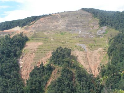
Suhaimi Jamaludin from CKC/JKR Malaysia presented a very interesting paper on the monitoring system that they have installed on the Pos Selim rock slide in the Cameron Highlands. The quality of the real time monitoring system is very high, but what was particularly interesting was the sequence of images showing the development of the slope (which is this one below).
On a different theme, Senro Kuraoka presented a very elegant analysis using computer modelling of the reasons why large particles migrate to the front of large debris flows. This is significant because this boulder arc causes huge amounts of damage when a flow hits a structure. The analysis suggested that two factors were important. First, the basal friction of the flow and second the ways in which the particles rotate. The author admitted that the results are not definitive, but they are certainly very helpful. The final paper that I saw on the first day was given by Dhakal and his colleagues from Nepal, who gave an overview of the use of bioengineering on road alignments based on their experience in the Himalayan mountain road sector. They presented some very interesting statistics on the occurrence of landslides on valley bottom vs ridge alignments, showing the incidence of failures on ridge alignments is far lower than at the bottom of the slope. I am unsurprised, but hope that this message is finally getting through.
An interesting element of the conference was that two sessions were dedicated to “country reports” in which key landslide people from a number of Asian countries presented their national state of play. I have mentioned already the presentation by Prof. Chen regarding China, but there was also a very nice presentation by Vishnu Dangol on Nepal, focusing very much on national frameworks for management, by Professor Marui on Japan and by colleagues from Thailand, Indonesia and Vietnam. Two key issues emerged for me:
- Many of the speakers in this session mentioned that empowerment at the local level is the way to deal with landslides in less developed countries. This may well be the case, but where is the evidence to support it? I have not seen a single scientifically-driven study that actually establishes the efficacy of this approach, even though it is taken as gospel by almost everyone. There is an urgent need to establish some research to investigate this. Prof. Strom made the point in discussion that maybe it is not helpful to continually remind people of the dangers associated with slopes, given that in most cases the risk is low compared with many other parts of their lives (e.g. food security, health, road safety). Perhaps actually in some cases it would be better to work structurally at a government level – after all, we know this works if implemented properly.
- There is an urgent need to undertake proper hazard mapping in many countries. It is a great shame that this is still not being done. It is also a tragedy that very skilled engineering geologists, with massive experience, are not being used by external agencies any more because of the low cost road ethos. This is a big mistake.
Finally, I do want to mention a presentation by one of my own PhD students, Katie Oven, who showed us how to give a clear and concise presentation on a very complex topic at an international meeting. She was in a class of her own.
So overall it was a great meeting with a terrific mix of people. I salute the organisers from the
Japan Landslide Society. I won’t be at the World Landslide Forum, but if it is as good as this meeting then it will be one to remember.
Comments welcome!
 Dave Petley is the Vice-Chancellor of the University of Hull in the United Kingdom. His blog provides commentary and analysis of landslide events occurring worldwide, including the landslides themselves, latest research, and conferences and meetings.