
22 May 2008
Beichuan landslide-dammed lake – new imagery
Posted by Dave Petley
NASA has now released new images collected by the FORMOSAT-2 satellite of one of the lakes forming near to Beichuan in Sichuan behind the landslide dam shown in this post (click on the image for a better view).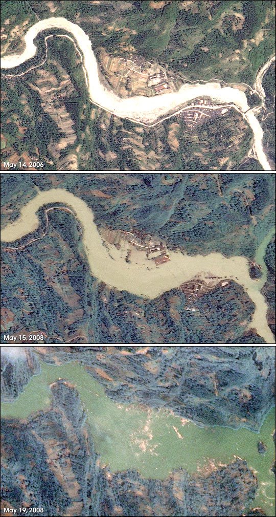
The first image shows a reach of the river upstream of the dam after the earthquake (on May 14th) but before the lake really started to form. The second image shows the lake a day later. Note that now the lake has started to fill, threatening the two villages built on the river banks. The river has overtopped its banks and is starting to inundate the farm land. In the third image, collected on 19th May, the lake is well formed. River flow has more or less stopped and a large pool has formed. Both villages and the farmland have been inundated. The only sign of them is a large amount of debris floating on the surface. This may well be all that is left of people’s houses.
Note that the volume of water behind the dam is large and that the lake is filling quickly. Although the authorities appear to be responding quickly and appropriately, this situation remains abolsutely critical. One can only hope that the reports in the Times yesterday, which said the following, are incorrect:
One plan is to build up earth barriers halfway across the Beichuan river, at several points downstream from the reservoir. These barriers would divert the water, slowing its flow and reducing the danger to communities in its path. Once these were ready, some or all of the water could be released over the next day or two, possibly by blasting away part of the landslide.
Such an approach would be unconventional at the very least. Blasting the landslides, rather than building a spillway, is not an experiment that I would recommend. The idea of controlling the resultant flow with barriers is at best optimistic.
 Dave Petley is the Vice-Chancellor of the University of Hull in the United Kingdom. His blog provides commentary and analysis of landslide events occurring worldwide, including the landslides themselves, latest research, and conferences and meetings.