
2 May 2008
April 2008 landslide map
Posted by Dave Petley
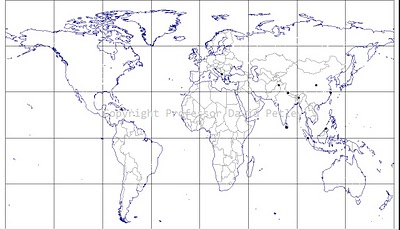
The map below shows the distribution of fatal landslides for April 2008.
The statistics are:
Number of fatal landslides: 12
Number of fatalities: 33
As I predicted in March, April was once again very substantially below the average for 2003-2007, which is 96 fatalities per year. The distribution is very random, with absolutely no clear pattern. Two fatal landslides occurred in the Himalayan Arc, which is a sign of things to come over the next few months. La Nina conditions do still prevail, but the event continues to weaken. Typically the number of landslides starts to increase around early May. This is shown by the cumulative totals – for example, at the end of April 2004 I had recorded just 339 fatalities for the year to date (this years total is even lower – 301), but by the end of May 2004 this had jumped to 1136. It could be an interesting month!
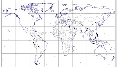
 April 2008 fatal landslide locations (click for a larger version)
Some patterns are starting to emerge in the annual map. Note in particular the emerging clusters in the Himalayas, western Central America, the Philippines and Indonesia. These are the normal locations for fatal landslide clusters. The cluster in the Himalayas is focused on the west side at the moment as this area gets heavy rain in the early part of the year. It will spread eastwards over the next three months.
 Dave Petley is the Vice-Chancellor of the University of Hull in the United Kingdom. His blog provides commentary and analysis of landslide events occurring worldwide, including the landslides themselves, latest research, and conferences and meetings.