
29 April 2008
The Frank Landslide, 29th April 1903
Posted by Dave Petley
As today is the 105th anniversary of the Frank Landslide in Canada, it seems appropriate to revisit this most interesting event. The town of Frank is located at about 49 degrees 35 minutes North and 114 degrees 24 minutes West at an elevation of about 1300 m in Alberta, Canada. The town on the back of coal deposits at the foot of Turtle Mountain to the west of the town (Figure 1). These were exploited by coal mines at the foot of the hill.
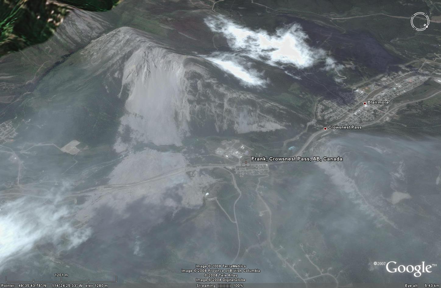 Figure 1: Google Earth image of the Frank landslide, Turtle Mountain, Alberta, Canada.
The landslide is fairly easy to see on Figure 1. The first signs of problems came in the weeks leading up to the collapse, when the coal tunnels started to show signs of movement. The final collapse occurred at 4:10 am when a block of about 650 m in height, 900 m in width and with a maximum thickness of about 150 m thick broke off the hillside and thundered into the valley below. The failure, which had an estimated volume of 30 million cubic metres, apparently took about 100 seconds, killing 76 people. Most of the victims were killed in their beds and their bodies could not be recovered as they were buried to a depth of about 30 m. Figure 2, from Natural Resources Canada, captures the scale of the event quite well. The landslide deposit extended over about 3 sq km, blocking the river and flooding about 2 km of the railway line. Seventeen coal miners were buried in the coal mine by the landslide but were able to dig themselves out over a 14 hour period.
 Figure 2: Natural Resources Canada photograph of the Frank landslide, Turtle Mountain, Alberta, Canada.
 The Frank landslide remains of great interest for a number of reasons:
- There has been considerable controversy over the cause of the landslide. Initially the blame was pinned squarely on the mining activities, but more recently it has been increasingly accepted that in fact the geological structure, which was unfavourable for stability, was probably the primary cause. The mining probably did not help, and other factors such as rainfall may have also had a role.
- There has also been a great deal of speculation over the the rate at which the landslide debris spread itself over such a large area. This very rapid runout behaviour is a somewhat enigmatic process in many large rockslides. Theories have abounded over the role of air entrainment, reduced basal friction, etc. The jury is still out – this remains one of the great questions in landslide science.
- Parts of the mountain are probably still potentially unstable. In 1911 part of the town was relocated over fears about the stability of the slope. Today, real time monitoring is undertaken by the Alberta Geological Survey using a wide range of sensors. The aim is not to prevent a failure event but to provide a warning that it might occur. This is fine for a progressive failure or for one triggered by rainfall, but it offers little if there should be a large earthquake. Nonetheless, this is important work that is undertaken to a world leading standard. The work is described exceptionally well here
 Dave Petley is the Vice-Chancellor of the University of Hull in the United Kingdom. His blog provides commentary and analysis of landslide events occurring worldwide, including the landslides themselves, latest research, and conferences and meetings.
At the time I visited the Frank landslide, I had no idea of its existence or of long-run-out landslides. I was traveling home from Watertown-Glacier and came upon it. Even from the road it is very dramatic, as the debris towers on either side and is starkly grey. There is an excellent visitors center. Since that time I have learned of similar landslides elsewhere, and there have been dramatic landslides in the Alps and in Yosemite. Fascinating but deadly.
Mr. PetleyHello my name is Greg Wannamaker I looked through your blog about the Frank slide at Turtle mountain at Crowsnest Pass. I am writing to you to ask if you might have any information about an A.R. Fairfield (Alfred Reginald Fairfield) According to my uncle he was the first engineer to go through the frank slide after the rail lines were cleared. I would like to know more about this subject as to the fact that A.R. Fairfield was my great great grandfather if you can find any information about this I would be pleased to hear of it. I am trying to do some research on the family and I found this story to be very interesting my email is [email protected] you for your time and I hope you can help me.Greg Wannamaker