14 December 2017
The continental U.S. is experiencing more flooding, and earlier in the year
Posted by Joseph Cariz
By Kimberly Hickok

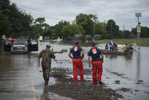
Members of the U.S. Coast Guard assist residents in a flooded Houston neighborhood on August 30, 2017. Scientists predict flooding in the Texas Gulf region to become more variable because of increased urbanization.
Credit: Coast Guard News
The frequency of flooding in the continental U.S. is increasing, and seasonality of floods is shifting, according to new research.
Flooding causes several million dollars’ worth of damage every year in the U.S. Hurricane Harvey alone caused unprecedented flooding for the city of Houston in August of this year, dumping over 50 inches of rain in less than four days. Being able to accurately predict flooding events can help preparation efforts be more effective, but flood models have a lot of uncertainty, according to Xiuyuan Li, a hydrologist and data scientist at Lehigh University in Bethlehem, Pennsylvania who presented the new research this week at the 2017 American Geophysical Union Meeting in New Orleans.
Li and her colleague Tara Troy, an environmental engineer at Lehigh University, wanted to improve flooding predictions by examining trends in historical data. In the new research, they used data collected by 3,250 flood gauges from 1950 to 2010 to analyze and map the annual occurrence of floods across all 18 U.S. Geological Survey water regions of the continental U.S. They looked at how stream flow, precipitation, soil moisture and snow changed during this time period.
The researchers found strong seasonality associated with floods in the western U.S., with the vast majority of floods occurring in December or January. In Utah, Idaho and Western Montana, flood seasonality is strong, with most floods occurring during May and June. The north-central U.S. experiences modest flood seasonality from April to June, while the South and East Coast don’t experience strong seasonality with their floods – they can happen any time of the year.
To see if flood seasonality has shifted in recent years, the researchers further analyzed data collected from the regions that experience strong flood seasonality and gauges that recorded over 40 flood events during the flood season. This analysis revealed that most regions with strong flood seasonality are seeing floods happen one to five days earlier on average. The exception is Southern California and a few spots in the central U.S. where flooding is instead occurring 1 to 5 days later on average.
In regions such as the Great Lakes, the researchers suspect floods are occurring earlier because of earlier snow melt. For some regions, like the Upper Colorado River, they found no clear environmental factor could explain the flood events. “We don’t have a very obvious reason [for floods in this region], so we need further analysis to dig into this,” Li said.

Houston experienced record rainfall last August when Hurricane Harvey stalled over the upper Texas coast for nearly four days. Flooding in the U.S. has been happening with more frequency and less seasonality.
Credit: Tom Fitzpatrick
The researchers also found an increasing trend of out of season floods occurring in the Great Lakes, Tennessee, Upper and Lower Mississippi River and Texas Gulf regions. The team predicts this trend of more frequent non-seasonal floods to continue because of increased urbanization or other human influences, Li said.
Having such a large-scale data set is valuable for understanding factors causing environmental changes, said Dai Yamazaki, a global hydrologist at the University of Tokyo who was not involved in this study.
“We need to analyze as many data as possible to see whether the changes [in flooding trends] are caused by a climate impact or other impact,” he said. Yamazaki said he was excited to see Li and Troy’s first large-scale analysis of flood data.
Li said she plans to further examine how urbanization and other potential human factors affect flooding occurrence. “We really need to look at spots case by case, to see what the [flood] drivers are,” she said.
— Kimberly Hickok is a graduate student in the Science Communication program at UC Santa Cruz. Follow her on Twitter at @kimdhickok.


 GeoSpace is a blog on Earth and space science, managed by AGU’s Public Information staff. The blog features posts by AGU writers and guest contributors on all sorts of relevant science topics, but with a focus on new research and geo and space sciences-related stories that are currently in the news.