3 May 2016
Scientists find likely cause for recent southeast U.S. earthquakes
Posted by Lauren Lipuma
New study shows pieces of the underside of the North American Plate peel off, sink into the mantle
By Lauren Lipuma

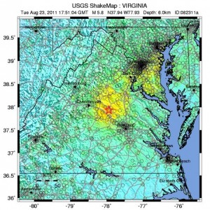
Shaking from the magnitude 5.8 earthquake near Mineral, Virginia on August 23, 2011 was felt by more people than any other earthquake in U.S. history, according to the U.S. Geological Survey.
Credit: USGS.
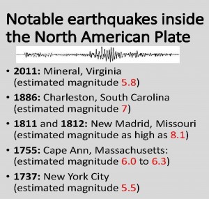
The southeastern United States should, by all means, be relatively quiet in terms of seismic activity. It’s located in the interior of the North American Plate, far away from plate boundaries where earthquakes usually occur. But the area has seen some notable seismic events – most recently, the 2011 magnitude-5.8 earthquake near Mineral, Virginia that shook the nation’s capital.
Now, scientists report in a new study a likely explanation for this unusual activity: pieces of the mantle under this region have been periodically breaking off and sinking down into the Earth. This thins and weakens the remaining plate, making it more prone to slipping that causes earthquakes. The study authors conclude this process is ongoing and likely to produce more earthquakes in the future.
“Our idea supports the view that this seismicity will continue due to unbalanced stresses in the plate,” said Berk Biryol, a seismologist at the University of North Carolina Chapel Hill and lead author of the new study. “The [seismic] zones that are active will continue to be active for some time.”
The study was published today in the Journal of Geophysical Research – Solid Earth, a journal of the American Geophysical Union.
Compared to earthquakes near plate boundaries, earthquakes in the middle of plates are not well understood and the hazards they pose are difficult to quantify. The new findings could help scientists better understand the dangers these earthquakes present, according to the study’s authors.
Old plates and earthquakes
Tectonic plates are composed of Earth’s crust and the uppermost portion of the mantle. Below that is the asthenosphere: the warm, viscous conveyor belt of rock on which tectonic plates ride.

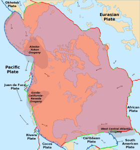
A map of the North American Plate. Arrows show directions of its movement across Earth’s surface.
Credit: Alataristarion via Wikimedia Commons.
Earthquakes typically occur at the boundaries of tectonic plates, where one plate dips below another, thrusts another upward, or where plate edges scrape alongside each other. Earthquakes rarely occur in the middle of plates, but they can happen when ancient faults or rifts far below the surface reactivate. These areas are relatively weak compared to the surrounding plate, and can easily slip and cause an earthquake.
Today, the southeastern U.S. is more than 1,700 kilometers (1,056 miles) from the nearest edge of the North American Plate, which covers all of North America, Greenland and parts of the Atlantic and Arctic oceans. But the region was built over the past billion years by periods of accretion, when new material is added to a plate, and rifting, when plates split apart. The authors of the new study suspected ancient fault lines or pieces of old plates extending deep in the mantle following episodes of accretion and rifting could be responsible for earthquakes in the area.
“This region has not been active for a long time,” Biryol said. “We were intrigued by what was going on and how we can link these activities to structures in deeper parts of the Earth.”
To find out what was happening deep below the surface, the researchers created 3D images of the mantle portion of the North American Plate. Just as doctors image internal organs by tracing the paths of x-rays through human bodies, seismologists image the interior of the Earth by tracing the paths of seismic waves created by earthquakes as they move through the ground. These waves travel faster through colder, stiffer, denser rocks and slower through warmer, more elastic rocks. Rocks cool and harden as they age, so the faster seismic waves travel, the older the rocks.
In the new study, researchers used tremors caused by earthquakes more than 3,500 kilometers (2,200 miles) away to create a 3D map of the mantle underlying the U.S. east of the Mississippi River and south of the Ohio River.
The study’s authors found plate thickness in the southeast U.S. to be fairly uneven – they saw thick areas of dense, older rock stretching downward and thin areas of less dense, younger rock.
“This was an interesting finding because everybody thought that this is a stable region, and we would expect regular plate thickness,” Biryol said.
At first, they thought the thick, old rocks could be remnants of ancient tectonic plates. But the shapes and locations of the thick and thin regions suggested a different explanation: through past rifting and accretion, areas of the North American Plate have become more dense and were pulled downward into the mantle through gravity. At certain times, the densest parts broke off from the plate and sank into the warm asthenosphere below. The asthenosphere, being lighter and more buoyant, surged in to fill the void created by the missing pieces of mantle, eventually cooling to become the thin, young rock in the images.

Volcanoes were once active in the southeastern U.S. Mole Hill, pictured here, is a mound of volcanic rock in the Shenandoah Valley in Virginia that formed from an active volcano 48 million years ago (a relatively recent event, in geological time scales).
Credit: Jstuby via Wikimedia Commons.
The researchers concluded this process is likely what causes earthquakes in this otherwise stable region: when the pieces of the mantle break off, the plate above them becomes thinner and more prone to slip along ancient fault lines. Typically, the thicker the plate, the stronger it is, and the less likely to produce earthquakes.
According to Biryol, pieces of the mantle have most likely been breaking off from underneath the plate since at least 65 million years ago. Because the researchers found fragments of hard rocks at shallow depths, this process is still ongoing and likely to continue into the future, potentially leading to more earthquakes in the region, he said.
—Lauren Lipuma is a public information specialist and writer at AGU. You can follow her on twitter at @lipumal.


 GeoSpace is a blog on Earth and space science, managed by AGU’s Public Information staff. The blog features posts by AGU writers and guest contributors on all sorts of relevant science topics, but with a focus on new research and geo and space sciences-related stories that are currently in the news.
This is the theory is very interesting. Does this also relates to craton in the northern part ??