27 September 2012
Scientists simulate growing role of Arctic climate culprit
Posted by mcadams

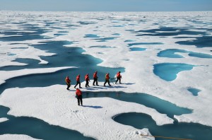
Sea ice researchers, surrounded by Arctic melt ponds, set out to check the thickness of an ice floe. Credit: Don Perovich
Every summer in the Arctic, a vast system of ponds appears on the broad beds of floating sea ice, only to freeze again when the cold season returns. Researchers consider these transient bodies of water – called melt ponds — an important factor in climate change because they absorb sunlight and contribute to sea-ice loss. While warming has increased the fraction of Arctic sea ice where melt ponds form, global climate models have remained incapable of accurately predicting the influence of melt ponds, scientists say. A new model, which incorporates complex physics of the ponds, is generating predictions of sea-ice extent and thickness that match well with observations, the model’s developers report. The researchers are introducing this new capability just weeks after the extent of Arctic sea ice shrank to an unprecedented autumn low that climate models were unable to predict.
Melt ponds accelerate global climate change by reducing the Earth’s albedo – the measure of how much sunlight bounces off the Earth back into space. The bright white surface of the Arctic sea ice has a high albedo. But as more melt ponds cover the ice, more sunlight gets absorbed by them, raising temperatures and causing more ice to melt, driving a cycle that causes yet more warming.
Climatologists had been accounting for melt ponds by directly altering albedos in their computer models rather than calculating the influence of melt ponds using physics. It’s that missing piece of the computational puzzle that Daniela Flocco, Daniel Feltham and David Schroeder of University College London built into their new model. “Climate models currently do a poor job of simulating sea ice cover in the Arctic,” said Feltham, an applied mathematician who specializes in the physics of sea ice. “The data tell a clear story of rapid Arctic ice loss. But the sea ice is definitely melting much more rapidly than the ice models predict.”
The team presents its model’s results in a study published 27 September in the American Geophysical Union’s Journal of Geophysical Research—Oceans.
Pinning down melt pond physics is especially tricky because the melting process itself continually alters the surface of the sea ice. For example, melting makes sea ice not just scarcer, but also flatter, said Feltham. While newly frozen ice is normally flat, much of the sea ice in the Arctic has survived for several years – long enough for ice floes to collide and grind the ice into a rough, lumpy shape. This lumpy ice favors melt ponds that are deep with a small surface area. But that lumpy, old ice is also increasingly melting away, leaving behind flatter ice. So shallow, wide ponds are becoming more prevalent on the ice surface, which is worse for the sea ice’s albedo.
Missing information on sea ice thickness presents another problem. Most information scientists have on the sea ice comes from satellites, which is useful but limited. “We can see, from space, the fraction of the ocean covered in sea ice,” said Feltham. “Those sorts of observations don’t tell us how thick the ice is, although things are improving with the recent launch of ice-observing satellite CryoSat 2.”
Satellites observations show that first-year ice recently began to dominate the sea ice surface, Feltham said.
The complex and constant change and absent thickness data makes sea ice one of the biggest unknowns in climate science, said sea ice geophysicist Don Perovich, who was not involved with the study but called it exciting. “This study makes a significant advance at putting a physical basis for melt ponds in models,” said Perovich. “Melt pond area is a key component and it isn’t something that can be readily extracted from satellites.”
The scientists’ new simulation manages many of the challenging complexities of melt-pond physics: how the water flows over the ice surface to collect in ponds, how some of that water drains through porous summer ice into the ocean, and the diminished albedo of the ice below a pond’s surface. The simulation also calculates the process of ridging, in which multiple ice floes press against each other, causing them to break and pile up to form ridges, during which melt water can drain into the ocean, preventing melt ponds from forming. The researchers have tested their melt pond simulation by adding it to a sea-ice model used by the United Nations Intergovernmental Panel on Climate Change, and comparing the souped-up model’s results to observations of the sea ice from 1990 to 2007.
The results came as close to observations of the ice as the models that had albedos corrected with the benefit of hindsight, the team reports. Feltham said this suggests their calculations of the physics of melt ponds are reliable. “When we compare our model against observation, we get a good match,” said Feltham, “and where we do have notions of sea ice thickness, from space or otherwise, like submarines, we get a reasonable measure of the observations of thickness as well.”
The simulation also reveals how much more prevalent the melt ponds became with time. The researchers report that their model identified 1996 as the year with the most ice surface and the fewest melt ponds, and 2007 as the least ice surface, but the most ponds. The researchers suggest that this means that melt ponds will matter even more as climate change continues, because an environment in which sea ice is scarcer and flatter is one in which melt ponds will flourish. “We have strong reason to believe melt ponds have a big impact,” said Feltham.
– Sean Treacy, AGU science writing intern


 GeoSpace is a blog on Earth and space science, managed by AGU’s Public Information staff. The blog features posts by AGU writers and guest contributors on all sorts of relevant science topics, but with a focus on new research and geo and space sciences-related stories that are currently in the news.