
15 December 2010
3D movies of the Earth as it changes
Posted by mohi
No sooner did I wish for a 3D movie at AGU, than I got one. Late on Tuesday USGS scientist Gerald Bawden presented some of his latest work and upcoming projects in the Bowie Lecture (G24A) Ultra-High Resolution Four Dimension Imaging Across the Earth Sciences – with fabulous 3D movies. Red and blue glasses on, the audience visited such places as the sheer rock walls above Yosemite’s Valley Floor; flew above, around and through Bay Area bridges, and visited the burned hillsides of southern California.
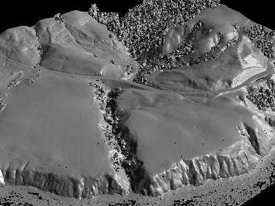
LiDAR image of part of the northern California coast. Image courtesy of the UC Davis Institute for Data Analysis and Visualization
Bawden, from the United States Geological Survey’s California Water Science Center, located on the Sacramento State campus, studies the Earth with LiDAR technology. This sensing technology, standing for Light Detection and Ranging, collects data (atmospheric, elevation, and seafloor data, to name a few kinds) through laser scanning.
LiDAR instruments fire laser pulses which reflect off the target and return to the instrument. The instruments can then calculate the 3D coordinates–latitude, longitude, elevation–of the object they are imaging. LiDAR scanners can be put on stationary tripods on land, or on boats, cars, aircraft, or satellites. The information they retrieve is accurate enough to show changes over time (this provided the fourth dimension referenced in the talk’s title). With this, Bawden can visualize and quantify how land masses, buildings, and bridges have moved after earthquakes.
Bawden believes that the importance of LiDAR technology will increase because knowledge of exact positions on the Earth’s surface has endless applications: modeling and monitoring rock falls, land slides, and snow melts, to name a few. It gives us a powerful tool for watching and understanding natural processes as they occur. Click here for an example of LiDAR imagery.
He highlighted, for example, the Debris-Flow Warning System developed jointly by the National Oceanic and Atmospheric Administration and the U.S. Geological Survey using LiDAR data. Bawden showed a movie, only two-dimensional–alas!–of a major debris flow on Christmas Day in 2003 in Devore, California. In it, heavy rains sweep water, soil, and rocks down from barren burned hill slopes in events that resemble flash floods. The 2003 debris flow was so powerful it carried boulders and ripped huge chunks of concrete off roads, ruining everything in its path. With this LiDAR-based early warning system, the public hopefully can avoid these catastrophic events.
The video literally caused gasps in the audience. See it for yourself, and be grateful that technology like LiDAR, and researchers such as Bawden, are working to warn and protect us from such intense, and frankly frightening, events.
–Danielle Venton is a science communication graduate student at UC Santa Cruz