
May 25, 2022
Lake Fork Knik River Headwater Glaciers, Alaska Retreat, Separation and Lake Expansion
Posted by Mauri Pelto
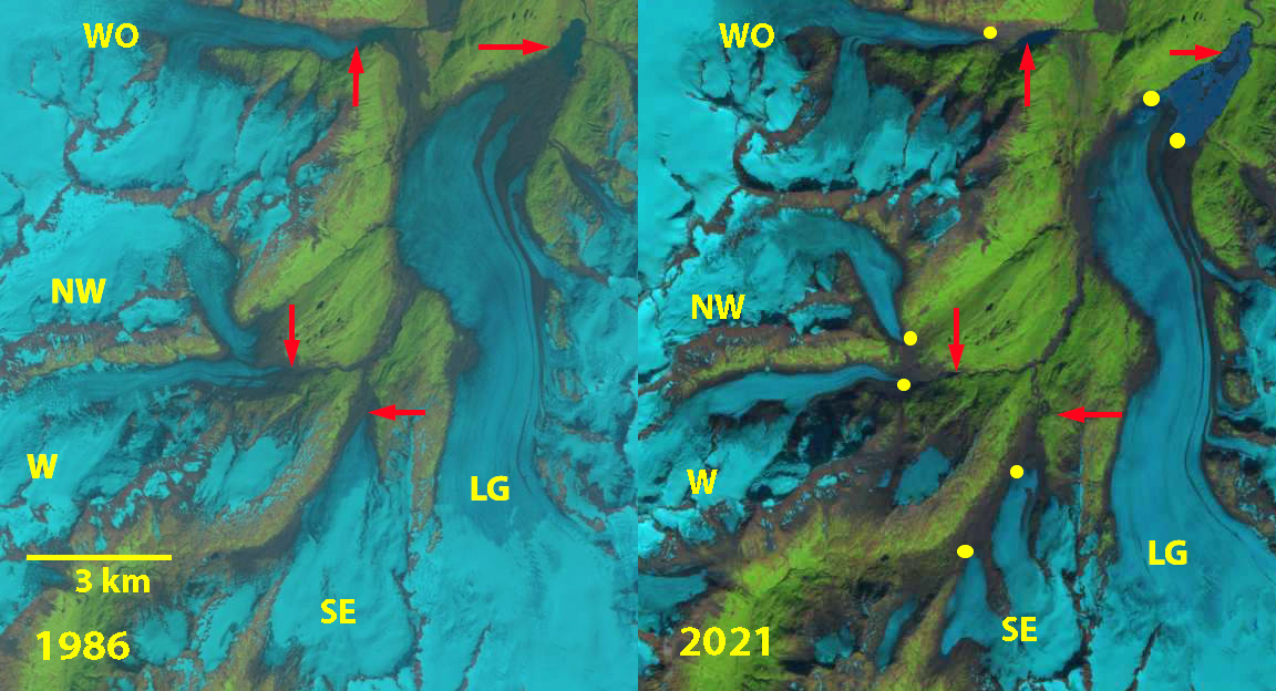
Glaciers in the Lake Fork Knik River watershed in 1986 and 2021 Landsat images. LG=Lake George Glacier and WO=Whiteout Glacier with the remainder unnamed, labelled here as W=West, NW=Northwest and SE=Southeast. Red arrows mark 1986 terminus locations and yellow dots the 2021 terminus locations.
At the headwaters of the Lake Fork of the Knik River are a series of glaciers undergoing retreat and separation. The headwaters is dominated by the Lake George Glacier, which had terminated in the large proglacial Lake George that periodically drained past/beneath Knik Glacier (Stone, 1963), after 1966 the lake no longer filled (Post and Mayo, 1971). A new smaller proglacial lake began to form due to the retreat of Lake George Glacier by. Here we examine the changes in this headwater glacier group from 1986-2021 with Landsat imagery. The proglacial lake at the terminus of Lake George Glacier is moraine dammed and has expanded from 1986-2021, this is representative of the expansion of moraine dammed lakes in Alaska with an 87% areal increase from 1984-2019 noted by Rick et al (2022).
In 1986 Lake George Glacier terminated in a small proglacial lake with an area of 0.3k m2,. Whiteout Glacier terminated at 300 m, within 3 km of LG. West and Northwest Glacier had a joint terminus (Point J) at 600 m, with two outlet streams O1 and O2. Southeast Glacier had a single terminus at 500 m and had an area of 18.4 km2,. In 2002 the main change was the separation of West and Northwest Glacier. The snowline on LG was at 900 m in August 2002. By 2019 Southeast Glacier has two separate termini, with the ridge just north of SE dividing the glacier, with the snowline at 1100 m in August. The proglacial lake at the end of Lake George had an area of 4.0 km2,. By 2021 the proglacial lake had expanded to an area of 4.3 km2,, a 4.0 km2, increase since 1986. Terminus retreat has been 2100 m for Lake George Glacier 1100 m for Whiteout Glacier, 1250 m for West Glacier, 1000 m for Northwest Glacier and 1100 m for Southeast Glacier. Southeast Glacier now has an area of 12 km2, a 33% area loss since 1986, ~1% per year. In 2021 the Outlet Stream from W, NW, and SE glacier parallels the margin of Lake George Glacier, but no longer goes under or is in contact. A notch at Point A has developed, from a meltwater runoff channel. Icebergs occupy much of the lake in 2021 indicating there is still active development of the lake. The lake development and separation of glaciers is similar to that observed at Field Glacier, Sheridan Glacier and Excelsior Glacier.
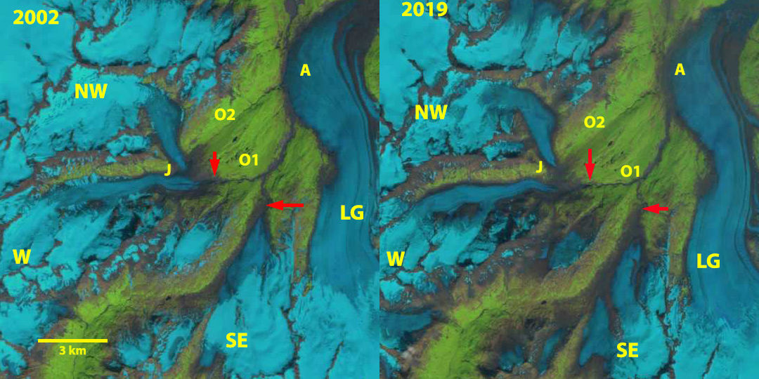
Glaciers in the Lake Fork Knik River watershed in 2002 and 2019 Landsat images. LG=Lake George Glacier with the remainder unnamed, labelled here as W=West, NW=Northwest and SE=Southeast. O1 and O2 are the outlet streams of the W and NW Glacier in 1986, with O2 abandoned by 2002.

Glaciers in the Lake Fork Knik River watershed in August 29, 2021 Landsat image. LG=Lake George Glacier and WO=Whiteout Glacier, with the remainder unnamed, labelled here as W=West, NW=Northwest and SE=Southeast. O1 is the outlet streams of the W and NW Glacier, yellow dots at right indicate the course. Note the notch in Lake George glacier at Point A.
 Dean of Academic Affairs at Nichols College and Professor of Environmental Science at Nichols College in Massachusetts since 1989. Glaciologist directing the North Cascade Glacier Climate Project since 1984. This project monitors the mass balance and behavior of more glaciers than any other in North America.